Ad

Showing posts with label weather. Show all posts

Tuesday, July 16, 2013

Signs of the Times. Wicked Weather.

Reporting the Signs of the Times, here is a bit on how drastically the weather is changing worldwide.  Due to these changes, you and your families need to prepare your home and your family in case of emergency.  Prepare your go-bags, bug-out bags, or 72 hour kits so that you can get out in a hurry, should you need to do so.  Also, prepare your food and water storage in case of contamination or shortage, among other emergencies.


Wednesday, June 5, 2013

Massive flooding through Germany, Poland, Switzerland, the Czech Republic and Austria

Surging rivers threaten cities in Czech Republic, Germany

By Laura Smith-Spark, Ivana Kottasova andBen Brumfield, CNN
updated 9:01 AM EDT, Wed June 5, 2013

A woman cleans mud from the footpath in front of her house following flooding along the Inn River in Schaerding, Austria, on Wednesday, June 5. Rising rivers menaced swaths of Germany, the Czech Republic and Austria on Tuesday, as floodwaters inundated historic cities and forced mass evacuations of low-lying areas.

(CNN) -- Parts of the Czech Republic and Germany braced for flooding Wednesday as surging rivers threatened more cities.

The floods are thought to be the worst since August 2002, when parts of Germany, the Czech Republic, Austria, Slovakia, Russia and Romania were affected.

Eight people have died as a result of this week's flooding in the Czech Republic, fire service spokeswoman Nicole Zaoralova said.

"The situation is still critical in the city of Usti," she said. "We are expecting the situation on the River Labe (Elbe) in the northern Bohemia region of Ustecko to become worse during the day. The river has not peaked yet, and the levels are rising."

"The situation in the next few days will obviously depend on the current weather situation. As of the moment, more heavy rains are forecast for the weekend."

The Elbe crosses the border into the eastern German state of Saxony soon after it passes through Usti nad Labem, so German cities downstream such as Dresden are also expecting the surge to arrive.

The Czech fire service is moving heavy equipment to regions that are still at risk, Zaoralova said.

In other areas in southern Bohemia, the focus is shifting to cleaning up, with equipment deployed to clear mud, she said.

More than 19,000 people have been evacuated from their homes, Zaoralova said.
Close to 23,000 firefighters, including volunteers, have been deployed across the Czech Republic so far, she said.

The Vltava River, which flows through the historic capital, Prague, has peaked there, but the fire service is monitoring for large debris that could damage landmarks such as the centuries-old Charles Bridge.

An excavator has been stationed on the bridge, which is much loved by tourists and locals, to ward off damaging wreckage.

Flood waters are starting to recede in some low-lying parts of the city.

Volunteer efforts

Saxony in eastern Germany is the most vulnerable area Wednesday, after river levels dropped slightly in much of Bavaria, farther south.

Flood warnings are in place for areas around the rivers Elbe, Lausitzer Neisse, Mulde, tributaries of the upper Elbe, Black Elster, Spree and White Elster, according to the German meteorological service.
Danny Arguello, an international business student in Dresden, told CNN iReport that he was impressed by the outpouring of volunteer support as residents try to protect the city.

As the rising Elbe River covers roads and sidewalks, groups of volunteers organized through Facebook are cooking food, moving sandbags and helping with other flood preparations, he said.
"The participation around the whole town is just amazing," he said.

In Bavaria, the Danube River has topped flood defenses downstream from Deggendorf. And in Vilshofen, it is about 125 centimeters (4 feet) above the highest flood stage, it said.

Water levels remain extremely high on the Danube between Regensburg and Passau, in southern Bavaria, the meteorological service said.

In Passau, where the Danube River is joined by two other rivers, water levels topped a 500-year-old record Tuesday.

At least two men are reported to have died in Germany's southwestern state of Baden-Wuerttemberg.
A fireman died Saturday after suffering a heart attack while responding to flooding in Wilhelmsdorf, according to the state's Interior Ministry.

read more at CNN

Germany's Dresden expects peak in flooding

Floods Across Central Europe:
Heavy rains swelled major rivers in Germany, the Czech Republic and Austria causing widespread destruction. 

By MELISSA EDDY

Published: June 5, 2013

PIRNA, Germany — Officials in eastern Germany’s river cities and towns on Wednesday urged citizens in vulnerable areas to evacuate their homes as the Elbe River and its tributaries swelled ever higher, amid some of the worst flooding that some regions have seen in centuries.

As Germany battles severe flooding in parts of the country, the cost of the damage is hitting Europe's biggest economy just as it has barely overcome a harsh winter that has driven it to the brink of recession.

In the first quarter of 2013, German Gross Domestic Product grew by just 0.1 percent. The country just managed to avoid a recession, which is defined as two successive quarters of economic contraction.

Much of the hope for economic recovery lies with key economic indicators which predict accelerating growth in the coming months.

However, economists are becoming more and more skeptical about the country's growth outlook as they fear that the much-vaunted spring upswing might drown in the deluge.

"As the flood levels rose, so did the problems for German businesses," says Alexander Schumann, chief economist at the German chambers for Industry and Commerce (DIHK).

He told DW that it was especially the construction industry which had been unable to boost activity due to the heavy rainfall. The sector was particularly hard hit, as it was already facing a huge backlog of orders stemming from the long and harsh winter in Germany.
As water levels rise in Germany's flood zones, the situation is growing more dramatic. It has been just over a decade since the country's last flood crisis, but little has been learned from that, critics say.

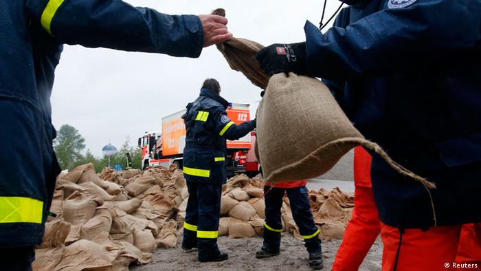
Members of the Federal Agency of Technical Relief (THW) load sandbags in Hirschfeld near Leipzig
REUTERS/Fabrizio Bensch
In 2002, torrential rainfall had led the Elbe River and its tributaries to burst their banks. Unprecedented water levels were recorded particularly in eastern Germany. The first major flood of the new century put the issue of flood prevention at the top of the political and social agenda.

But Andreas Schumann, a water supply expert at Germany's Ruhr University, says the memory of the 2002 catastrophe has already faded, adding, "We have an incredible deficit when it comes to awareness about flooding."

That is a problem in places where people have moved closer to the rivers from generation to generation, which is true in many parts of Germany.

Flooded streets near Chemnitz in the state of Saxony
Photo: Arvid Müller/dpa
"We must keep flooding areas free of development," Schumann stresses, but notes that this principle is often abandoned due to people's tendency to underestimate the risks of severe flooding.

The water expert adds that many feel a false sense of security due to the preventative technical measures undertaken, like higher and more stable dams and levies.
No perfect protection
Flooded streets near Chemnitz in the state of Saxony
Saxony was among the German states especially hard hit by the 2002 flooding. When asked how Saxony responded in the years afterward, state parliamentarian and environmental expert Andreas Heinz first said that much money was invested in technological measures like improved dams or larger reservoirs intended to absorb water in emergency situations.

A dike near the Oder River
Photo: Patrick Pleul dpa/lbnAndreas Schumann confesses that such measures represent a step forward. "There, the weak spots were recognized and improved," he said, but added, "There is no such thing as absolute flood protection and technological flood prevention measures must always include considerations of what happens when they fail."

Winfried Lücking, an expert on flood protection with the German environmental group BUND, sees things differently. He says there has not been enough consideration of how the dangers of flooding could be better controlled. At a national conference on river issues in 2002, the federal government urged people to give the bodies of water more space. The point in doing so is reducing water levels by allowing more room for the water to flow, including into flood plains with dikes positioned somewhat further away from riverbanks than they often are currently.

"Regrettably, little has been done," Lücking says. On the Elbe, just a handful of dikes were put in place - and partly due only to heavy pressure and involvement from environmental groups.

Creating adequate dikes, however, represents a mammoth project that cannot be completed quickly. For generations, people have pushed the dikes closer and closer to the rivers themselves as areas near their banks have been developed more heavily. Lücking notes this process cannot simply be reversed within a decade, particularly in light of the complicated planning involved.

'Each event is different'

Undertaking flood prevention measures collides with a number of other interests. Landowners do not want to give up their fields, homeowners are unwilling to part with their residences and communities fear limitations to their development potential. As such, resistance runs high when it comes to allowing more space for rivers to spill over their banks.

"Everyone says, you're welcome to do that, just not near us," explains Winfried Lücking.
READ MORE AT DW

German city copes after worst flood in 500 years

Prague Zoo evacuated and Charles Bridge closed as river waters rise


The Associated Press>

Posted: Jun 4, 2013 8:30 AM ET 

Last Updated: Jun 4, 2013 10:50 PM ET


Germany dispatched thousands of soldiers Tuesday to help cities and towns cope with flooding from the rain-soaked Danube and other southern rivers — reinforcements that came a day after the Bavarian city of Passau saw its worst flooding since 1501.
The death toll rose to at least 10, including seven in the neighboring Czech Republic, where a man was found dead in the water in eastern Bohemia. Another nine people have been reported missing in the floods that have also swept through Austria and Switzerland.
Chancellor Angela Merkel toured flooded German regions, pledging €100 million ($135 million Cdn) in immediate federal help and holding out the possibility for more. She told reporters in Passau, a city of 50,000 on the Austrian border, that the damage looked even worse than during the massive flooding that hit central Europe in 2002.
Some 5,000 German soldiers were called in as well as more than 2,000 federal disaster workers and 700 federal police to sandbag areas in danger of flooding and provide other assistance. Water levels were still rising in major rivers such as the Danube and Elbe as well as tributaries.
In the Czech Republic, authorities evacuated animals from the Prague zoo and closed a major bridge in the capital on Tuesday.
The rain in Prague has halted but the Vltava River that runs through the city and flows into the Elbe was still raging, with currents and water levels far exceeding the norm. The famous Charles Bridge was closed as a precaution.


Katerina Sulova / Zuma Press
Prague, Czech Republic - A Humboldt penguin watches flood waters rise from inside its enclosure at the Prague Zoo, as the swollen Vltava river continues to rise.
passau, germanyOn the outskirts of Prague, a major Staropramen beer brewery on the river bank was closed as a protective measure — as were several major chemical factories. One of them — Spolana — released dangerous toxic chemicals into the Elbe during the devastating floods of 2002.
Authorities said the level of the Vltava in Prague has now begun to drop but excess water was expected to soon hit the Elba river, into which it flows downstream.
This year's spike in water levels has been far less than in 2002 so far, but still forced the Prague Zoo to evacuate animals after the lower side of the park was submerged and will once again need major reconstruction.

Passau, a city built around the intersection of the Danube, the Inn and the Ilz rivers, has been one of the worst hit by the flooding in central Europe.
After hitting the highest level in more than 500 years in Passau on Monday, the floodwaters there had dropped by an estimated 2.5 metres Tuesday but cities downstream like Regensburg were bracing for the water's arrival.
READ MORE AT CBC.CA


Vit Simanek / AP
The Prague Zoo flooded by the swollen river Vltava photographed in this Tuesday June 4 aerial view.
Heavy rainfalls caused flooding in in Germany, Austria, Switzerland and the Czech Republic
Flooding in Czech Republic, Germany, Austria

03/06 04:26 CET


The month of June normally heralds the official arrival of summer, but parts of central Europe find themselves struggling with floods.
In the historic centre of Prague, the mayor has warned residents may have to be evacuated from their homes if the River Vitava gets any higher. 300 soldiers are helping to build temporary barriers and pile sandbags around buildings. Another 2000 are on standby.
The Prime Minister has declared a state of emergency for most of the nation. At least two people have died and several others are missing.
Patients have already been evacuated from a hospital under threat from the rising water. Animals have also been rehoused from the city zoo.


Southern and Eastern Germany have also been affected. Three rivers meet here at the city of Passau. Some have resorted to using boats to get around the streets.
And in Austria, torrential rain has caused widespread flooding and landslides, forcing hundreds of people to leave their homes.
Train lines have been closed in affected areas.
SOURCE: EURONEWS.COM

Barbara Gindl / EPA
Firefighters begin clean up efforts after water flooded streets and houses in Huettau, Salzburg, Austria, on.June 4. Flooding since June 1 has so far claimed at least nine lives and led to mass evacuations. Several others have been reported missing as a result of the floods, which cover an area stretching from southern Germany, through to Poland, Switzerland, the Czech Republic and Austria.

Friday, January 11, 2013

Earth Directed Solar Flares. Asteroid DA14...Watch Out. Solar Maximum.


INCREASING CHANCE OF FLARES: Big sunspot AR1654 is growing more active. It is now crackling with M-class solar flares, such as this one recorded by NASA's Solar Dynamics Observatory this morning at 09:11 UT:


AR1654 is getting bigger as it turns toward Earth: movie. Not only is the chance of flares increasing, but also the chance of an Earth-directed eruption.This could be the sunspot that breaks the recent lengthy spell of calm space weather around our planet

X-ray Solar Flares
6-hr max: M1 
1508 UT Jan11 
24-hr: M1 
0911 UT Jan11 
explanation | more dataUpdated: Today at: 2000 UT


Daily Sun: 11 Jan 13

Sunspots AR1652 and AR1654 have beta-gamma magnetic fields that harbor energy for M-class solar flares. Credit: SDO/HMI

SPACE WEATHERNOAA Forecasts
Updated at: 2013 Jan 10 2200 UTC
FLARE
0-24 hr
24-48 hr
CLASS M
50 %
50 %
CLASS X
05 %
05 %

Asteroid 2012 DA14 to sweep close on February 15, 2013

It’ll pass within the moon’s distance from Earth – closer than the orbits of geosynchronous satellites. But it won’t strike us in 2013.

A near-Earth asteroid – called 2012 DA14 by astronomers – will pass very close to Earth on February 15, 2013. Astronomers estimate that, when it’s closest to us, it’ll be within the orbit of the moon (which is about 240,000 miles away), and within the orbits of geosynchronous satellites (about 26,000 miles up). 2012 DA14 will be about 21,000 miles (35,000 kilometers) away. It will not strike Earth in 2013. Astronomers’ calculations of asteroid orbits can be trusted. After all, even decades ago, they knew enough about calculating orbits to send people to the moon and bring them safely back, and today we are able place our space vehicles in orbit around objects as small as asteroids.
So, no, 2012 DA14 won’t strike us in 2013. There was a remote possibility it might strike us in 2020, but that possibility has been ruled out also.

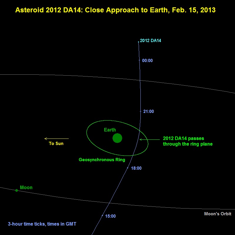
Asteroid 2012 DA14 will pass closest on February 15, 2013. As the image above shows, it will pass much closer than the orbit of the moon - closer even that orbiting geosynchronous satellites (22,000 miles). View larger. Image Credit: NASA
What will happen when Asteroid 2012 DA14 passes closely in 2013?
What will happen when it passes us? The short answer is … nothing. On the day it passes, most of us won’t see it or be aware of its passage, in any way. The asteroid won’t alter the tides. It won’t cause volcanoes. It’ll just sweep closely past us – as millions of asteroids have done throughout Earth’s four-and-a-half-billion-year history – some in your own lifetime.
The asteroid will be within range for small telescopes and solidly mounted binoculars, used by experienced observers who have access to appropriate stars charts. Here’s what NASA says about its visibility:
On [February 15, 2013], the asteroid will travel rapidly from the southern evening sky into the northern morning sky with its closest Earth approach occurring about 19:26 UTC when it will achieve a magnitude of less than seven, which is somewhat fainter than naked eye visibility. About 4 minutes after its Earth close approach, there is a good chance it will pass into the Earth’s shadow for about 18 minutes or so before reappearing from the eclipse. When traveling rapidly into the northern morning sky, 2012 DA14 will quickly fade in brightness.
What do we know about asteroid 2012 DA14?
Asteroid 2012 DA14 is a little guy, compared to some asteroids, although its size has not been pinned down precisely. It is thought to be about 45 meters across (nearly 150 feet across), with an estimated mass of about 130,000 metric tons.
If a space object 150 feet wide were to strike our planet, it wouldn’t be Earth-destroying. But it has been estimated that it would produce the equivalent of 2.4 megatons of TNT. How does that compare with other known impact events on Earth? In 1908, in a remote part of Russia, an explosion killed reindeer and flattened trees. But no crater was ever found. Scientists now believe a small comet struck Earth. That event has been estimated at 3 to 20 megatons. So 2012 DA14 is in the same approximate realm as the Tunguska comet (which, actually, might have been an asteroid instead). It would not destroy Earth, but it could flatten a city.
Of course, about 70% of our world is covered by oceans. That means the most likely landing spot of any incoming asteroid is in the water – not on a city or other populated area.
Astronomers at the Observatorio Astronómico de La Sagra in Spain discovered 2012 DA14 in early 2012. We know 2012 DA14′s orbit is similar to that of Earth. That is one reason the asteroid eluded astronomers until recently. You can be sure that many astronomers are carefully tracking 2012 DA14 now.
The orbit of 2012 DA14 is an inclined ellipse. In other words, it’s tilted sightly with respect to Earth’s orbit around the sun, and, like Earth’s orbit, it’s not circular but elliptical – like a circle that someone sat down on. According to Bad Astronomer Phil Plait, who appears to have used a computer program to look at its orbit:
The asteroid spends most of its time well away from our planet. However, the path of the rock does bring it somewhat close to the Earth twice per orbit, or about every six months. The last time it passed us was on February 16 [2012], when it was about 2.5 million km (1.5 million miles) away, equal to about 6 times the distance to the moon. That’s usually about the scale of these encounters — it misses us by quite a margin.
If we know it will miss us in 2013 and in 2020, why are astronomers still watching? In fact, the orbit of 2012 DA14 is not entirely pinned down, although it is known well enough to say for sure: it will not hit us next year, or in 2020.
But it will come close on February 15, 2013! It should be close enough to catch the attention of virtually everyone on Earth in February 2013, on what’s sure to be a media field day.
Will 2012 DA14 strike Earth in 2020?
No. In March 2012, when a collision between 2012 DA14 and Earth in 2020 was still remotely possible, I asked astronomer Donald Yeomans to clarify the risk. Yeomans is, among other things, manager of NASA’s Near-Earth Object Program Office at NASA’s Jet Propulsion Laboratory. In March 2012, he told EarthSky that a 2020 collision between Earth and asteroid 2012 DA14 was …
… approximately one chance in 83,000, with additional remote possibilities beyond 2020. However, by far the most likely scenario is that additional observations, especially in 2013, will allow a dramatic reduction in the orbit uncertainties and the complete elimination of the 2020 impact possibility.
It turned out they didn’t have to wait until 2013. By May, 2012, astronomers had ruled out even the remote possibility of a 2020 collision.
Still, 2012 DA14 and asteroids like it are sobering.
Bottom line: The near Earth asteroid 2012 DA14 will have a very close pass near Earth on February 15, 2013. It will sweep approximately 21,000 miles from us – much closer than the moon’s orbit and closer than geosynchronous satellites. It will not strike Earth. Its orbit around the sun can bring it no closer to the Earth’s surface on February 15, 2013 than 3.2 Earth radii.


Solar Variability and Terrestrial Climate

The March Towards Max

The March Towards Max
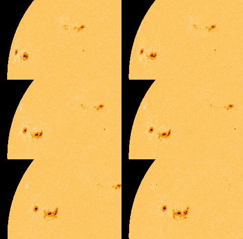
These six images from SDO, chosen to show a representative image about every six months, track the rising level of solar activity since the mission first began to produce consistent images in May, 2010. The period of solar maximum is expected in 2013. The images were taken in the 171 Angstrom wavelength of extreme ultraviolet light.

Sun-Climate (tsi, strip)
Space-borne measurements of the total solar irradiance (TSI) show ~0.1 percent variations with solar activity on 11-year and shorter timescales. These data have been corrected for calibration offsets between the various instruments used to measure TSI. SOURCE: Courtesy of Greg Kopp, University of Colorado.


Sun-Climate (pacific anomaly, strip)
Composite averages for December-January-February for peak solar years. SOURCE: G.A. Meehl, J.M. Arblaster, K. Matthes, F. Sassi, and H. van Loon, Amplifying the Pacific climate system response to a small 11 year solar cycle forcing, Science 325:1114-1118, 2009; reprinted with permission from AAAS.


Sun-Climate (sunspot numbers, strip)
The yearly averaged sunspot number for a period of 400 years (1610-2010). SOURCE: Courtesy of NASA Marshall Space Flight Center.


Monday, October 29, 2012

Current News On Hurricane Sandy. Video Footage. Photos.

HERE ARE THE CURRENT HEADLINES REGARDING HURRICANE SANDY...


Hurricane Sandy: Tens of thousands already without power

Matt Moran, a trimmer with Townsend Tree Service, cuts a fallen tree limb from a power line on 19th Avenue that fell as a result of the strong winds from Hurricane Sandy, Monday, Oct., 29, 2012, in Sea Cliff, N.Y. / AP PHOTO/KATHY KMONICEK
Last Updated 12:36 p.m. ET
Hours before Hurricane Sandy makes landfall, utilities have already reported power outages for customers in several states. More than 67,000 customers were without power in Virginia, Delaware, New Jersey, and several other states.
Connecticut
Connecticut Light & Power (which offers outrage reports in both map and tableformats) says about 16,200 customers were without power Monday.
Delaware
Delmarva reports about 1,500 customers without power.
Maryland
BGE reports restoring service to about 4,000 customers Monday; about 2,300 are still without power.
Additional scattered outages were reported by Mon Power and Potomac Edison, and by PEPCO.
Massachusetts
NStar reported about 2,500 outages Monday morning. National Grid had fewer than 1,000 outages, down from about 5,200 earlier in the morning.
New Jersey
More than 24,400 customers in the Garden State are without power.
Public Service Electric & Gas, which is tweeting outage information, says 2,100 customers are offline. Jersey Central Power & Light, whichpublishes map of outages, is reporting 16,800 homes are without power. Atlantic City Electrichas about 5,500 outages,
New York
LILCO reports more than 21,000 customers on Long Island were without power Monday morning. Con Edison reports at least 2,000 customers in New York City and in Westchester County are without power.
In Upstate New York NYSE&G reports 3,900 customers affected.
North Carolina
Duke Energy reports more than 4,100 customers without power. Progress Energyreports more than 1,100 customers without power Monday morning.
Pennsylvania
PPL Electric Utilities reports more than 2,100 customers without power in eastern Pennsylvania.
Rhode Island
National Grid says about 2,600 customers had lost power by around 9 a.m. Monday.
Virginia
Dominion Virginia says it has restored power to about 3,000 customers by early Monday; about 2,000 remain without service.
read more at : http://www.cbsnews.com

Hurricane Sandy: Monday's Rare NYSE, Nasdaq Closing Likely To Last Through Tuesday


NEW YORK, NY - OCTOBER 28:  Construction worke...
NEW YORK, N.Y.--Construction workers carry boards of wood to cover air vents that could cause the New York subway system to flood in preparation for Hurricane Sandy on October 28, 2012 in New York City.  (Image credit: Getty Images via @daylife)

U.S. trading came to a halt this morning, as exchanges across the country ended early or didn’t open at all. The pause come hours before Hurricane Sandy even made landfall, raising the odds that the exchanges will stay closed tomorrow.
“It’s hard to imagine that we would open tomorrow,” NYSE Euronext CEO Duncan Niederauer told CNBC.
Originally, the NYSE hoped to shift trading to its electronic NYSE Arca exchange, which is not based near New York. The Nasdaq, already an electronic platform, had intended to stay open as well. The decisions came just before midnight on the East Coast, and officials say they later today will make a decision about whether to stay closed tomorrow. Bond markets will end trading early today at noon.
The shuttering of the two exchanges will halt U.S. stock trading and mark an unusual occurrence; significantly, the move to Arca would have meant the first time that the NYSE operated as an all-electronic exchange. It is the first time in 27 years, for example, that the NYSE will stay closed for weather. The NYSE opened the day after Tropical Storm Irene’s Sunday arrival last year: This time, the major difference is that Hurricane Sandy will hit on a Monday, and transportation will stay offline, a NYSE spokesman told FORBES.

Hurricane Sandy delivers high winds and torrential rain

Storm destroys downtown pier in Ocean City


Hurricane Sandy sent powerful waves crashing onto the boardwalk in Ocean City, Maryland.


As Hurricane Sandy pounds the mid-Atlantic coast Monday, the Baltimore region is bracing for gale-force winds and flooding.
The area remains under a flood watch through Tuesday evening, with coastal flooding expected late Monday into Wednesday morning, according to the National Weather Service. Heavy rain, as much as six inches, and high winds, with gusts as much as 70 miles per hour, will occur throughout Monday afternoon and well into Tuesday, according to forecasters.
Gov. Martin O'Malley warned of the danger of the storm Monday. "There will be people who will die and are killed in this storm," the governor said while visiting the Maryland Emergency Management Agency. "Stay off the roads, hunker down with your families."
Waves pound, winds whip, residents hunker down as Hurricane Sandy hits state


Bill Greene/Globe Staff


Jillian Webb and Arianna Corso of Dennis braved the elements to go to Lighthouse Beach in Chatham today, where Hurricane Sandy pelted them with wind and sand.

Waves are pounding the shores and winds are whipping through the trees this morning as the effects of Hurricane Sandy slowly intensify in Massachusetts. With coastal flooding expected, officials warned people in several seaside communities to evacuate.

Residents are hunkering down at home, with schools, state and federal government offices, and many businesses closed. Roads are emptier than usual, and the state highway department urged truckers to “seek refuge at secure locations.” The MBTA also announced that it would discontinue all service at 2 p.m.

More than 17,000 electric customers across Eastern Massachusetts had lost power at about noon today. The latest National Grid power outage map shows more than 9,000 customers affected. NStar is reporting more than 6,200 customers without power. “We have close to a thousand crews working on storm restoration,” Caroline Pretyman, NStar spokeswoman, said in an e-mail. Unitil is reporting more than 1,000 customers are without power.

The state is at the outer edges of a “superstorm” that is expected to crash into the mid-Atlantic states later today. The storm, which had been steaming north through the ocean, has made a westward turn and is zeroing in on the coast, according to the National Weather Service.

As of 11 a.m. today, the storm was about 260 miles southeast of New York City, expected to make landfall near Cape May, N.J., at 11 p.m. Exactly where the landfill will happen is still uncertain, said weather service meteorologist Charlie Foley. “It’s kind of like a wait and see,” he said. “It has made its left turn, but where it makes landfall isn’t exactly definitive.”

Sandy is a Category 1 hurricane carrying 90-mile-per-hour winds. The storm is moving north-northwest at 18 miles per hour, according to the National Hurricane Center. Forecasters have urged the public not to underestimate its strength even hundreds of miles away from where it makes landfall.


Romney Scraps Monday Night and Tuesday Campaigning


Republican presidential candidate Mitt Romney is curtailing his campaign schedule as Hurricane Sandy bears down on the Eastern seaboard, canceling planned appearances Monday night and all day Tuesday.
Campaign officials say vice presidential running mate Paul Ryan will also scrap campaign rallies during the same time frame.
Romney 2012.JPEG
AP
Republican presidential candidate and former... View Full Caption
The decision was announced a short while after President Barack Obama canceled a planned rally in Florida to fly back to Washington, where aides said he would oversee the government's response to the threat posed by the storm.
Romney intends to go ahead with speeches today in Ohio and Iowa before he begins observing his self-imposed storm-related moratorium on campaigning.
The former Massachusetts governor and Obama are locked in a close race, eight days before Election Day.
Hurricane Sandy: Major Storm as Atmospheric Forces
Combine

By rights, Hurricane Sandy ought never to have had a chance to form. Back in May, just before the 2012 hurricane season began, the National Oceanographic and Atmospheric Administration  said this was likely to be an average year, with perhaps nine to 15 named storms.
Instead, there have been 19 — 10 of them hurricanes — and it is not over yet. In terms of numbers of storms, this will go down as the third busiest Atlantic hurricane season since record-keeping began in 1851, exceeded only by 2005 (the off-the-charts year of Katrina) and 1933.
So what happened? The original outlook by NOAA’s Climate Prediction Center was about as accurate as it could have been at the time, all the way back last spring. But the oceans and the atmosphere make for a complex system, and the Northeast is suffering now because of patterns that formed as far away is Indonesia.
In the air over southeastern Asia is a phenomenon called the Madden-Julian Oscillation, or MJO — air currents that can shift back and forth in 30 cycles of 30 to 60 days. It usually means very little to Americans, as  it mostly affects Asian monsoons. But late this summer it shifted to feed increased amounts of warm, moist air to the east, toward the Pacific, and ultimately toward the United States.
“We had a busy start to the hurricane season — 13 named storms by the end of September, though only Isaac did anything to the U.S.,” said Paul Knight, a meteorologist at Penn State University. “After that there was a lull. Then the MJO began to act up.”
On top of it, there was El Nino, the giant strip of warm water in the Pacific that periodically forms along the equator, rearranging jet streams that flow over it. An El Nino began to weaken just in the past few months — bad news for people along the Atlantic 10,000 miles away. For lack of a strong El Nino, there were not the usual high-level air currents that would help break hurricanes apart as they tried to move toward the U.S. coastline.
read more at http://abcnews.go.com