Ad

Showing posts with label Preparedness. Show all posts

Monday, October 3, 2016

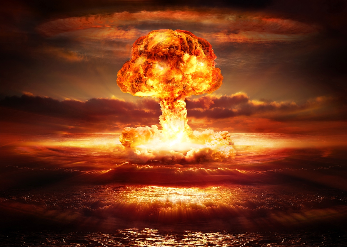
40 Million Russian Citizens Take Part In Nuclear Drill, October 4-7th, 2016

Connected events...

~US Suspends Diplomatic Relations With Russia On Syria

~"On August 22, The BBC in London reported that the government of Germany had begun urgently telling their citizens to store emergency food and water "in case of a disaster which threatens our existence."  That story remains on the BBC web site.

Days after Germany told its citizens to stock up on food and water, the Czech newschannel CT24 broadcast a message from the government telling citizens to ‘prepare for the worst’."

~NOW FINLAND TOO! Local Councils Warning Citizens "Stockpile Food & Water - Prepare" as US TANKS go on the move!

~"Moreover, no one, in the entire history of human existence, has ever put 40 million people into bomb shelters over a three day period as some sort of "exercise."  The entire economy of Russia will grind to a complete halt.  The cost and logistics involved in doing this are . . . . staggering! "

Wednesday, September 28th, 2016 at 2:20pm EDT" (back up date October 5th)

~"Here's another POSSIBLE interpretation of the coming "exercise" :  What if we're going to be attacked by a full barrage of nuclear missiles, once the Russians have a third of their population safely tucked away in underground bunkers?  That could mean sometime very near October 7 or shortly thereafter."

~"Frankly, right now would be the perfect time for Russia to launch an actual attack.  "

~Germans told to stockpile food and water for civil defence


~"Days after Germany told its citizens to stock up on food and water, the Czech news channel CT24 broadcast a message from the government telling citizens to ‘prepare for the worst’."

~updated information:

As of October 3, 2016, the first formal session of the newly elected legislature (originally scheduled for October 17) has been moved up to October 5, from a bomb shelter.

Intelligence rumor is that the moving up of the meeting, and from a bomb shelter, is to start war.

~The U.S. has also decided to commit to wartime activities inside Syria, regardless of whether we hit Russia or not.

With all of this, any enemy could attack us with an EMP. Damage to our civilization from such an attack would be catastrophic. 

Tuesday, July 16, 2013

Signs of the Times. Wicked Weather.

Reporting the Signs of the Times, here is a bit on how drastically the weather is changing worldwide.  Due to these changes, you and your families need to prepare your home and your family in case of emergency.  Prepare your go-bags, bug-out bags, or 72 hour kits so that you can get out in a hurry, should you need to do so.  Also, prepare your food and water storage in case of contamination or shortage, among other emergencies.


Thursday, January 24, 2013

The New Madrid Fault. Booms. Earthquake. Methane Gas Releasing. Sinkhole.

THE FOLLOWING WILL BE IMPORTANT REGARDING THE NEW MADRID FAULT...
The following video...


Published on Jan 15, 2013
Plug in all the data and see for yourself, here's the links:

BOOMS:

Guthrie, Oklahoma: http://kfor.com/2013/01/04/mysterious-boom-heard-in-guthrie/
Cater County, Oklahoma:http://www.kten.com/story/20271784/loud-booms-heard-across-texoma-has-confirm...
QUAKES:
Spencer, Oklahoma:http://earthquake.usgs.gov/earthquakes/eventpage/usc000eli9#summary
Healdton, Oklahoma:http://earthquake.usgs.gov/earthquakes/eventpage/usc000ei5q#summary

BOOMS:

Evensville, Indiana http://www.14news.com/story/20537321/did-you-hear-the-booms
http://tristatehomepage.com/fulltext-news?nxd_id=575392
QUAKE:
Marion, Illinoishttp://earthquake.usgs.gov/earthquakes/eventpage/nm011113a#summary

BIRDS FALLING DEAD:

Seymour, Tennesee http://www.newschannel9.com/news/top-stories/stories/dead-birds-fall-sky-3646...
QUAKE:
Madisonville, Tennesseehttp://earthquake.usgs.gov/earthquakes/eventpage/se010813a#summary

BOOMS:

Lexington County, South Carolinahttp://www.wistv.com/story/20525068/searching-for-the-cause-of-booms-reported...
Columbia County, Georgiahttp://www2.wjbf.com/news/2012/dec/06/3/several-loud-booms-reported-columbia-...

Explosion Sounds:

Trumbull County, Ohiohttp://www.wkbn.com/content/news/local/story/Explosion-Sounds-Reported-in-Tru...

BOOMS:

Jamestown, New York http://www.wivb.com/dpp/news/local/loud-boom-jolts-southern-tier

BOOMS:

Salem, Massachusetts http://salem.patch.com/articles/did-you-hear-a-loud-bang-eary-saturday-morning
Barrington, Rhode Islandhttp://www.wpri.com/dpp/news/local_news/east_bay/explosion-heard-on-bay-nothi...

QUAKE:

Hawkesbury, Canadahttp://earthquake.usgs.gov/earthquakes/eventpage/ld60023403#summary
Boothbay Harbor, Mainehttp://earthquake.usgs.gov/earthquakes/eventpage/usb000enwr#summary

Canada Seismic Hazard map:

http://atlas.nrcan.gc.ca/site/english/maps/environment/naturalhazards/earthqu...

USGS Earthern US Seismic Hazard Map:

http://www.usgs.gov/blogs/features/files/2012/08/Screen-Shot-2012-08-28-at-1....

BOOM/QUAKE Map of everything pinned:

https://maps.google.com/maps/ms?msid=200270150651160417375.0004d3458c51989c71...


Areas prone to collapse sinkholes

The map below shows areas of the United States where certain rock types that are susceptible to dissolution in water occur. In these areas the formation of underground cavities can form and catastrophic sinkholes can happen. These rock types are evaporites (salt, gypsum, and anhydrite) and carbonates (limestone and dolomite). Evaporite rocks underlie about 35 to 40 percent of the United States, though in many areas they are buried at great depths.
Map of the United States showing areas where rock that are prone to dissolution and sinkholes are prevalent.

source: USGS

Monster Sinkholes An Indication That Major Earth Changes Are Coming Along The New Madrid Fault?

The most powerful earthquakes in the history of the United States happened along the New Madrid Fault in 1811 and 1812.  Those earthquakes were reportedly felt more than 1,000 miles away.  Scientists assure us that one day we will once again see very powerful earthquakes along the New Madrid fault.  It is only a question of when it will happen. Today, the New Madrid fault zone covers portions of Illinois, Indiana, Missouri, Arkansas, Kentucky, Tennessee and Mississippi.  However, a major earthquake of magnitude-8.0 or greater would likely have a dramatic effect all the way from the Great Lakes all the way down to the Gulf of Mexico.  When most Americans speak of the “big one”, they think of what may happen along the coast of California someday, but the truth is that a New Madrid earthquake could potentially do far more damage.  So is there evidence that the New Madrid fault zone is waking up?  Yes, there is.  According to Bloomberg, there has been “a sixfold increase in the number of earthquakes that have shaken the central part of the U.S. from 2000 to 2011″.  Much of that increase is being blamed on human activity such as mining, drilling and fracking.  So could human activity aggravate the fault zone so much that it could set off a truly history-making earthquake at some point?  Well, the potential is certainly there.  That is why so many people are so concerned about the monster sinkholes that have appeared in the region in recent months.  For example, a massive sinkhole down in Louisiana is now over 8 acres in size and it has forced hundreds of people to flee from their homes.  You can see video of the Louisiana sinkhole right here.  Over in Ohio, a giant sinkhole has suddenly formed that is more than 30 feet deep and that is the size of four football fields.  That sinkhole caused part of State Route 516 to collapse and authorities say that it will likely be closed for many months.  You can see video of the gigantic sinkhole in Ohio right here.  Are these monster sinkholes an indication that major earth changes are coming along the New Madrid fault?  Has reckless human activity awoken a sleeping giant that we should never have messed with?
The sinkhole down in Louisiana is of particular concern because it has been venting natural gas.  A few days ago it reportedly “burped” which sounds kind of ominous.  Could we see some kind of an “explosion” at some point?
Many of those living in the area may not be able to return to their homes for quite a long time.  The following is from a recent Huffington Post article…
At the eight-acre, Bayou Corne sinkhole in Assumption Parish, owners of slab houses are waiting for methane-gas monitors to be installed in December. The sinkhole deepened in November and coughed up debris and hydrcarbons late in the month. Cypress trees fell into the gap. Residents are watching natural gas being flared from the site and are ventilating homes while bayous around them bubble.
But if human activity is capable of producing sinkholes that are 8 acres in size and capable of causing a “sixfold increase” in the number of earthquakes in the middle part of the country, is human activity also capable of setting off the New Madrid fault?
Sadly, even most Americans that are living in that part of the country don’t really understand how incredibly massive and how potentially destructive this fault zone actually is.  The following is from a recent report from WREG in Memphis, Tennessee
Many people don’t realize that north Alabama lies in the impact zone of the New Madrid fault line, a sleeping giant that is approximately twenty times larger than California’s famed San Andreas fault. 
The biggest earthquake in U.S. history happened in the New Madrid seismic zone in 1812, and in just the last few weeks, activity along the fault line is starting to heat up. 
If the earthquakes that happened along the New Madrid fault zone in 1811 and 1812 happened today, the devastation would be unimaginable.  Back then, there were not that many people living in the area.  But even so, the destruction was incredible…
Accounts of the 1812 quake vary since there were no measuring instruments at the time, but most geologists say evidence shows it was at least a magnitude 8 earthquake, and possibly a 9 or higher.
The shaking was so intense that church bells started ringing as far away as Boston and New York.
Chimneys toppled from the Deep South to Canada, and President James Madison was awoken by the violent shaking as he slept in the White House.
Eyewitnesses said it even caused the Mississippi River to flow backwards for a time.
Unfortunately, there are now indications that the fault zone is becoming more active as a recent Examiner article explained…
Tuesday evening, two shallow earthquakes, although small, were felt in Mt. Carmel, Ill. as well as five miles outside Edmond, Okla. Illinois had the largest at 3.6 magnitude, leaving Oklahoma with a smaller 2.9 magnitude quake as reported by the USGS.
The fact that both of these quakes were shallow and follow on the heels of Kentucky’s 4.3 just 10 days ago makes the questions begin to fly. Is the New Madrid waking up? Is it gearing up for ‘the big one’? When Ky. Experienced a 4.3two weeks ago, it was felt across 10-12 states. Although it didn’t knock runners off their feet, it did alarm many. Knoxville was among the cities that felt the quake. The shaking was not minor in many areas, and it scared people as walls shook and many began to pray.
This is something that I have written about previously, and we all need to keep our eyes open for more reports about earthquakes in the middle part of the country.  When the “big one” does finally hit the New Madrid fault zone, it will be one of the biggest news stories ever.
We are talking about a catastrophe that would be so immense that it would be hard to imagine.  According to ABC News, a study by the Mid-America Earthquake Center found that in the event of a major earthquake along the New Madrid fault, “nearly 750,000 buildings would be damaged, 3,000 bridges would potentially collapse, 400,000 breaks and leaks to local pipelines and $300 billion in direct damage and $600 billion in indirect losses would occur.”
You can ready much more about the New Madrid fault right here.
All of this is even more frightening when you consider that there are 15 nuclear reactors along the New Madrid fault zone.
In the event that the “big one” strikes, we could be looking at Fukushima times 15.
We have been blessed to have avoided a major earthquake like that for so long in the middle part of the country, but there is no guarantee that the New Madrid fault zone will always be stable – especially considering how much it is being aggravated by man-made activity.
There are even some that believe that eventually we will see an earthquake of magnitude-9.0 or higher along the New Madrid fault.  Such an earthquake could literally change the face of the entire continent.  We are talking about an event that could potentially change the course of the Mississippi River and create bodies of water where none existed previously.
We seem to be moving into a time of increased seismic activity on the earth, and many scientists are convinced that the New Madrid Fault zone is definitely overdue for a major earthquake.

Massive sinkhole swallows Florida home


A home in Hudson, Fla., along Florida's west coast, was ripped apart Wednesday after a massive sinkhole opened beneath it.
No one was inside the house, belonging to 79-year-old Susan Minutillo, when it quietly crumbled to the ground, neighbors said.
“You just look over there and the whole back end of the house just flipped right down into the hole,” neighbor Mike Richards told First Coast News in Jacksonville, Fla.
Ironically, Minutillo was having her home evaluated for the risk of sinkholes when the ground opened up. As crews were surveying her property, she stepped out to run an errand, and by the time she got home, about half of her house was already in the ground, according to Pasco County Fire Rescue crews.
...As many as 150 sinkholes are reported in Florida each year. 
read more at NBC
LOUISIANA SINKHOLE...DANGEROUS GASES BEING RELEASED


12 May 2011 A large sinkhole has developed at the corner of Downing and S. Edsel in Detroit.


Thursday, November 29, 2012

Stretch Zones? Pole Shift? Sink Holes All Across The Globe.


DOVER, Ohio — State and federal experts were examining the site of a massive sinkhole on Thursday, trying to determine what caused it and how it can be repaired.

The collapse happened along State Highway 516 just west of Dover.  It took the westbound lane of the two-lane highway with it into a lake from which a family owned asphalt company has been dredging sand and gravel for years.
Some estimate the size of the gaping hole as big as several football fields wide.
The site attracted dozens of spectators on Thursday who could hardly describe what they were seeing.
“I’m not sure what to make of it.  I’ve never seen anything like this before in my life,” said Jennifer Smith of Dover, who was there with her young daughter and husband, Jesse, who was worried that the hole might grow even larger.
The collapse happened in a matter of moments at about 2 p.m. on Wednesday.

read more on http://fox8.com


Massive Sinkhole Still Growing – Ohio: 4 Football Fields Long, Shuts Down 8 Mile Stretch Of Road

Another massive sinkhole has emerged, this time outside of Dover, Ohio. According to WTOV9, emergency crews have been forced to close down an 8-mile stretch along a road in Tuscarawas County because of the rapidly growing monster.

Officials said the sinkhole is 30-feet deep and as long as four...


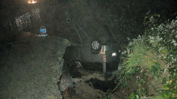
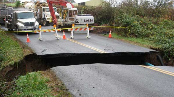
Man barely escapes as car plunges into Washington sinkhole


A man got out of his car just before it fell into a huge sinkhole in the middle of a La Center road early Saturday.

Just before 2 a.m., 47-year-old James Sandvik of La Center was driving down Northeast Charity Road when his car got stuck on the edge of a ravine that was caused by a wash out.


Sandvik got out of the car with minor injuries just before it plunged over the edge. The car then washed more than 1000 feet away as water continued to pour through a broken pipe caused by a plugged colvert, said Sgt. Alex Schoening with the Clark County Sheriff's Office.


The hole is at the 31000 block of NE Charity road, which connects to Lockwood Creek Road and runs south to Battle Ground. Traffic is detoured three miles and the road is expected to be closed for a long time.


Authorities urge drivers to avoid the area if possible.


Louisiana Sinkhole ‘Burps’. Official: Earth moved under giant sinkhole for 4 minutes straight – Before Crude oil disgorged “the water level dropped by about 6 inches”…

BAYOU CORNE, LA (WAFB) – Officials with the Assumption Parish Police Jury say the giant Louisiana sinkhole in Bayou Corne “burped” around 11:30 a.m. Tuesday. A few trees in the southwest corner of the sinkhole fell in during the event and vegetative debris and hydrocarbons came up from below the sinkhole. Texas-Brine removed all crews from the sinkhole and is checking the boom surrounding the area to make sure everything is intact


WAFB 9 News Baton Rouge, Louisiana News, Weather, Sports


Thailand
Nov 19, 2012


 Tuesday, Nov. 13, 2012

Huge sinkhole opens up in Windermere neighborhood


ORANGE COUNTY, Fla. — 
A huge sinkhole has opened up in one Windermere neighborhood and has residents on alert.
Officials said the hole is over 50 feet wide and 10 feet deep, but it isn't threatening any homes on Wax Berry Court.
An engineer is at the scene, trying to determine if the hole is getting bigger.
"Big [and] deep. The walls of the septic tank are hanging right there," said homeowner Paul Padfield.
Padfield didn't notice anything strange when he took his 8-year-old son Alex to school Monday morning, but he said they came home to the sinkhole.
Padfield said the view from his home has changed dramatically.
"There are dents all over the place. You've got little sinkholes all over," Padfield said.
Engineers said they spent Monday afternoon measuring the sinkhole and looking for shifts in the ground.


by Khan, Ning


EXPLANATION?

HERE'S ONE...

Stretch zone incidents - where rock pulls apart or snaps, creating booms and vibrations and hums, dropping bridges that lose their moorings or snapping gas and water mains, or creating sinkholes or crevasses - are not considered earthquake incidents. Quakes occur when rock borders slide along each other or push under one another, creating a jolt or a series of jolts. Stretch zone accidents  only happen when major plate movement is occurring, and are usually silent so do not get the attention that jolting earthquakes get. A bridge slips off its mooring and is attributed to heavy trucks or poor construction. A sinkhole appears and is attributed to ground water erosion. A building implodes and is attributed to settling, even though the building may have been there for centuries.


Mexico giant earth cracks, 3rd time in weeks: House swallowed, people panic


""It felt like an earthquake, everything moved, the ground started to open. We got scared because we saw the house as it collapsed. We were outside, saw the house collapsing and ran."
This is not the first, but one of many occurrences of this type in Mexico, which is definitely in a stretch zone.
For example, on Sunday, July 1, 2012, a gigantic crack opened in the earth in Dolores Hidalgo, Guanajuato. The land suddenly sank creating a crack about 13 ft. (4 m) wide by 196 ft. (60 m) deep, and 9 miles (15 km) long. Another hole also opened to one side of the first crack. It was so deep that the bottom of it could not be seen."
Mexico land cracks up; house swallowed, people panic

Mexico; house swallowed


Are the Earth's poles shifting in 2012?

Pole shift refers to a geological phenomena in which the Earth's outermost layers move together as one piece.
Image © HowStuffWorks.com

Some say the world will end in fire; some say ice. Lately, screenwriters and apocalypse enthusiasts have preferred natural cataclysms as their world-killers. As for when the end will arrive, those folks who claim to be in the know have an affinity for stamping 2012 as the Earth's sell-by date.
Why 2012? The answer traces back to true believers' interpretations (and reinterpretations) of Nostradamus, Edgar Cayce and various other ambiguous and nonscientific sources. Some armchair eschatologists have narrowed the expiration date further, to Dec. 21, 2012 -- when, they argue, the Mayan Long Count calendar ends its 5,125-year cycle. However, experts agree that the Mayans themselves did not believe that the world would end on this date, so feel free to buy green bananas on Dec. 19, 2012 [source:MacDonald].
The lack of scientific evidence for the coming apocalypse hasn't deterred believers from trotting out scientific theories to serve as evidence of imminent mass destruction. One of the most remarkable ideas they've chosen to flog is the pole shift hypothesis, in which the Earth's crust and mantle (or outermost layers) move as one piece. Pole shift might send the poles sliding toward the equator, swing North America poleward or produce any arrangement that might result from turning a globe in your hands.
People have been batting around some version of the pole shift hypothesis since at least the mid-19th century and, although many of the scientific questions it attempted to answer have since been addressed by plate tectonics, it's rooted solidly in physics. Plate tectonics and pole shifts interact and are governed by the same forces, but pole shifts, in which the outer shell of the world moves as one piece, produce very different results than plate tectonics, in which pieces of the Earth's crust bump, grind and slide -- opening seas, building mountain ranges and rearranging continents.
If a large pole shift could happen suddenly, the redistribution of land and water it caused would be nothing short of cataclysmic. In the short term, it would mean earthquakes, strange weather patterns, massive tsunamis capable of drowning parts of continents, and possibly gaps in the planet's magnetic field -- our shield against harmful cosmic rays. In the long term, the redistribution of land and water in the tropics, subtropics and poles would fundamentally alter ocean currents and the heat balance of the Earth, resulting in widespread climatological shifts. Ice caps might melt and reform elsewhere, or remain melted, driving sea levels down or up.
All of which returns us to the question: Could such a catastrophic shift occur, and if so, will it happen in 2012? We'll tell you next -- if the world doesn't end before you click to the next page.
SOURCE: http://science.howstuffworks.com/environmental/earth/geophysics/2012-earths-poles-shifting.htm

Sunday, October 28, 2012

Update:10-28-2012 - update on B.C. Earthquakes and tsunamis.

update 10-18-2012


CTVNews.ca Staff
Published Sunday, Oct. 28, 2012 8:15AM EDT 
Last Updated Sunday, Oct. 28, 2012 9:48PM EDT

Aftershocks continue to hit B.C. coast after 7.7 quake

Hundreds of aftershocks hit British Columbia including a 6.4-magnitude tremor Sunday afternoon,following one of the strongest earthquakes to the area in decades.
The province’s coastline was walloped with a 7.7-magnitude earthquake just after 8 p.m. PT Saturday. The U.S. Geological Survey said the earthquake struck at a depth of 17 kilometres centred 139 km south of Masset in the Haida Gwaii region.
Residents inVancouver’s mainland felt the intense quake with smaller tremors reaching the Greater Vancouver Area. Peopleas far as Edmonton, Alberta also reportedly feelingaftershocks well into Sunday. Tremors are expected to continue for days but many will go unnoticed.
The quake prompted a number of tsunami warnings along the province’s coastand as far away as Hawaii and California, but all were called off Sunday.
Still no reports of injuries or significant damages have been reported aside from personal belongings broken and misplaced from the tremors.
Tsunami warnings were issued for a large stretch of the North and Central coast, as well as the Haida Gwaii region. These Tsunami warnings prompted some residents to evacuate their homes. Haida Gwaii and other coastal communities such as Tofino sought out higher ground.
All of the warnings affecting British Columbia’s coastline were called off at about 3:22 a.m. Sunday in a bulletin from the U.S. National Weather Service’s West Coast/Alaska Tsunami Warning Center.
Though the threat of a damaging tsunami has passed, strong waves off the coast of B.C. still pose a risk to boaters and swimmers, oceanographer Tad Murty told CTV News Channel Sunday.
“Even if the tsunami amplitude is small, the currents could be very strong,” he said.
The largest wave that lashed against Langara Island, in the Haida Gwaii area, measured 69 centimetres.
The earthquake produced strong waves that travelled north to the Alaska panhandle and south towards California and the Hawaiian islands, CTV Meteorologist Michael Kuss reported Sunday.
Environment Canada had urged residents in low-lying areas of coastal B.C. to seek higher ground as tall waves lashed the province’s shoreline. CTV British Columbia’s Penny Daflos reported that at least three communities -- Sandspit, Bella Bella and Prince Rupert -- were evacuated as a precaution.
Power outages were reported at some B.C. homes, while others said the tremor rattled their nerves and caused objects to fly off shelves.
Carsten Ginsburg, who lives in the small community of Bella Coola southeast of Prince Rupert, said the quake lasted for about 40 seconds.
"It shook everything. The electricity went out, the power lines were swinging all over the place and stuff was falling off the shelves,” she told The Canadian Press on Sunday.
In a conference call recorded late Saturday night, B.C. Justice Minister Shirley Bond told reporters the province was “certainly grateful at this point” that there appeared to be little damage.
Concerns that information was not passed quickly enough by the B.C. government to local officials has been raised. Bond told the Canadian Press she was pleased with the response but a formal review will be conducted.
“Obviously minutes and hours matter when there is a potential catastrophic event, so what I want to do is refine the process so that we do that as well as we possibly can,” Bond told the Canadian Press.
Tsunami advisories were also cancelled in Oregon, Alaska and northern California on Sunday. Under an advisory, strong waves and significant sea level fluctuations are expected but evacuations aren’t necessary.
Saturday’s earthquake was the strongest to hit Canada since 1958, when a 7.9-magnitude quake struck near the British Columbia-Alaska border, according to Natural Resources Canada.
Just nine years before then, an 8.1-magnitude quake hit west of the Queen Charlotte Islands, in the same area that the most recent quake took place.
Earlier this month, more than 590,000 people participated in an earthquake preparation drill called The Great British Columbia ShakeOut. Participants were taught to “drop, cover and hold on” in case of a tremor.
Following the quake, speculation rose regarding the idea of when the “big one” would happen – an earthquake that only happens every 500 years but would cause extensive damage in B.C. and Northwestern U.S.
The last one occurred in January 1700, when a 9.0-magnitude earthquake struck offshore of Vancouver Island.
According to Brent Ward, an earth scientist at Simon Fraser University, the “big one” would occur on a different fault line. It is expected to fall on the edge of the Juan de Fuca plate west of Vancouver Island. When that plate finally gives way Ward warns the results will be catastrophic.
Ward said the focus right now should be on the smaller quakes as they are likely to strike more frequently.
-With files from The Canadian Press


Read more: http://www.ctvnews.ca/canada/aftershocks-continue-to-hit-b-c-coast-after-7-7-quake-1.1013869#ixzz2AeVp16C9


Hawaii tsunami warning canceled after lower than expected waves

HONOLULU | Sun Oct 28, 2012 6:12pm EDT

(Reuters) - Hawaii state officials on Sunday canceled a tsunami advisory prompted by a powerful earthquake off the Canadian coast that sent thousands of people fleeing to higher ground, but did not cause major damage.

The advisory was canceled shortly before 4 a.m. local time (1400 GMT) after the anticipated waves rolled in lower than expected, according to the Pacific Tsunami Warning Center.

Kevin Richards, earthquake and tsunami manager for Hawaii State Civil Defense, said water, gas and power lines were not damaged by the smaller-than-expected waves.

"Everything is normal," Richards said. "We're in good shape with this one."

Tens of thousands of people fled shoreline areas on Saturday night following siren blasts and a tsunami warning from the center that waves as tall as 6 feet could hit in some places.

Scientists downgraded the warning to an advisory shortly after 1 a.m. Sunday (1100 GMT) and there were no reports of injuries, serious flooding or damage.

The highest wave measured 2.5 feet, and that hit Kahului harbor on the island of Maui, said Dr. Gerard Fryer, senior geophysicist at the Pacific Tsunami Warning Center.

All beaches were reopened on Oahu, the most populated island in Hawaii, on Sunday morning, Richards said. Beaches remained closed on the island of Hawaii, but were set to reopen shortly.

Tsunami warning sirens began blaring across the islands at about 8 p.m. on Saturday as state officials ordered a coastal evacuation, prompting a mass exodus that clogged roadways as motorists fled low-lying areas.

On Oahu, the sirens prompted an immediate crush of traffic in Honolulu, with many motorists stopping at service stations to top up with gasoline.

Vindell Hsu, a geophysicist at the tsunami warning center, said the evacuation affected an estimated 100,000 to 150,000 people who live in Hawaii's coastal zones.

But residents and visitors resumed their daily lives around the state on Sunday. One woman, vacationing at a beachfront home in Kailua, Oahu, said this is the second time she has been evacuated from a tsunami warning.

"I do not think the state over-reacted at all," said Heidi Wilson, a San Diego resident. "I was blown away at the coordinated effort on all the islands. I felt secure with all the precautions."

The warnings followed a magnitude 7.7 earthquake that hit off Canada's Pacific coastal province of British Columbia late on Saturday.

The U.S. Geological Survey said the quake was centered 123 miles south-southwest of Prince Rupert at a depth of 6.2 miles.

The Earthquakes Canada agency said the temblor was followed by numerous aftershocks as large as magnitude 4.6 and that a small tsunami had been recorded by a deep-ocean pressure sensor.

The last time Oahu had a tsunami warning was after the devastating Japanese earthquake of March 2011.

Fryer said scientists overestimated the wave sizes in part because deep ocean sensors had a bad angle on the tsunami. The Pacific Tsunami Warning Center plans to carefully review the event.

"We have to see what worked and what didn't work ... and find ways to reduce unnecessary evacuations and still not miss anything," Fryer said.

(Additional reporting by Jolyn Rosa in Honolulu; Writing by Alex Dobuzinskis; Editing by Dan Whitcomb and Stacey Joyce)

..................end update......................................................................
Hawaii is bracing for Tsunami...


M7.7 - 139km S of Masset, Canada2012-10-28 03:04:10 UTC

Summary

Location and Magnitude contributed by: USGS, NEIC, Golden, Colorado (and predecessors)

General

50 km
20 mi
Powered by Leaflet
Canada
52.769°N, 131.927°W
Depth: 17.5km (10.9mi)

Event Time

  1. 2012-10-28 03:04:10 UTC
  2. 2012-10-27 20:04:10 UTC-07:00 at epicenter
  3. 2012-10-27 21:04:10 UTC-06:00 system time

Location

52.769°N 131.927°W depth=17.5km (10.9mi)

Nearby Cities

  1. 139km (86mi) S of Masset, Canada
  2. 202km (126mi) SSW of Prince Rupert, Canada
  3. 293km (182mi) SW of Terrace, Canada
  4. 556km (345mi) NW of Campbell River, Canada
  5. 635km (395mi) SSE of Juneau, Alaska


Tectonic Summary

The October 28th, 2012 (October 27 at the location of the epicenter) M 7.7 earthquake south of Masset, Canada, occurred as a result of oblique-thrust faulting near the plate boundary between the Pacific and North America plates. At the location of this event, the Pacific plate moves approximately north-northwest with respect to the North America plate at a rate of approximately 50 mm/yr.

This earthquake is likely associated with relative motion across the Queen Charlotte fault system offshore of British Columbia, Canada. Studies of tectonics in this region suggest plate motions are taken up by strike slip faulting parallel to the plate boundary, accompanied by lesser amounts of thrust motion to accommodate the oblique nature of the plate motion vector between the two plates with respect to the orientation of the main plate boundary fault structure. This oblique component of plate motion may involve either underthrusting of the western edge of the Pacific Plate beneath North America, or be taken up on crustal faults within the North America plate. The October 28th earthquake is consistent with either scenario.

This region of the Pacific:North America plate boundary has hosted 7 earthquakes of magnitude 6 or greater over the past 40 years – the largest of which was a M 6.6 earthquake in 2009, 80 km to the south east of the 2012 earthquake. In 1949, a M 8.1 earthquake occurred closer to the Pacific:North America plate boundary, likely as a result of strike-slip faulting, approximately 100 km northwest of the October 28th earthquake, near the northern extent of Haida Gwaii region (formerly Queen Charlotte Islands).


When they go to commercial, the picture will go black. It will come back when the commercial is over.

Hawaii News Now - KGMB and KHNL


Watch live... Hawaii News Now - KGMB and KHNL