Ad

Showing posts with label space weather. Show all posts

Friday, November 6, 2015

Solar Flare - Significant Delays In Sweden Airports

In keeping with the topic of interest, a recent solar flare caused significant delay in Sweden airports STORY FOUND HERE


The Sun stripped away the atmosphere of Mars' atmosphere, causing catastrophic climate change. This happened because of solar wind being spewed from eruptions from Sun spots, much like what happens when we have solar flare eruptions that face Earth. MORE ON THIS STORY HERE


The graphic above is located HERE

NASA revealed beautiful 4K footage of the Sun shown below.


Coronal holes are very common and so are solar flares.  However, many solar flares don't get directed straight towards Earth.  If a large X-Class flare erupts from a Sun spot (Coronal Hole), shooting a coronal mass ejection (CME) straight towards Earth, air traffic can be disrupted, electrical grids can be damaged and beautiful aurora lights can be seen.  MORE ON CORONAL HOLES HERE

CLICK HERE for more on space weather.

Thursday, May 23, 2013

7.4 Magnitude (possibly two back-to-back) Hits South of the Figi Islands. No Destructive Tsunami Detected.


Source of graphic: Nexrad, Intellicast


000
WEHW42 PHEB 231727
TIBHWX
HIZ001>003-005>009-012>014-016>021-023>026-231927-

TSUNAMI INFORMATION STATEMENT NUMBER   1
NWS PACIFIC TSUNAMI WARNING CENTER EWA BEACH HI
727 AM HST THU MAY 23 2013

TO - CIVIL DEFENSE IN THE STATE OF HAWAII

SUBJECT - TSUNAMI INFORMATION STATEMENT

THIS STATEMENT IS FOR INFORMATION ONLY. NO ACTION REQUIRED.

AN EARTHQUAKE HAS OCCURRED WITH THESE PRELIMINARY PARAMETERS

   ORIGIN TIME - 0719 AM HST 23 MAY 2013
   COORDINATES - 23.1 SOUTH  176.6 WEST
   LOCATION    - SOUTH OF THE FIJI ISLANDS
   MAGNITUDE   - 7.4  MOMENT

EVALUATION

 BASED ON ALL AVAILABLE DATA A DESTRUCTIVE PACIFIC-WIDE TSUNAMI IS
 NOT EXPECTED AND THERE IS NO TSUNAMI THREAT TO HAWAII. REPEAT. A
 DESTRUCTIVE PACIFIC-WIDE TSUNAMI IS NOT EXPECTED AND THERE IS NO
 TSUNAMI THREAT TO HAWAII.

THIS WILL BE THE ONLY STATEMENT ISSUED FOR THIS EVENT UNLESS
ADDITIONAL DATA ARE RECEIVED.

$$

Source: http://www.breakingnews.com

M7.4 - 282km SW of Vaini, Tonga2013-05-23 17:19:04 UTC

Event Time

  1. 2013-05-23 17:19:04 UTC
  2. 2013-05-23 05:19:04 UTC-12:00 at epicenter
  3. 2013-05-23 11:19:04 UTC-06:00 system time

Location

23.025°S 177.109°W depth=171.4km (106.5mi)

Nearby Cities

  1. 282km (175mi) SW of Vaini, Tonga
  2. 287km (178mi) SW of Nuku`alofa, Tonga
  3. 712km (442mi) SE of Suva, Fiji
  4. 812km (505mi) SE of Nadi, Fiji
  5. 818km (508mi) SSE of Lambasa, Fiji
  6. Tectonic Summary

    The May 23, 2013 Mw 7.4 earthquake southwest of Vaini, Tonga, occurred as a result of normal faulting at a depth of approximately 170 km. At the location of this earthquake, the Pacific and Australia plates are converging at a rate of approximately 73 mm/yr in an east-west direction, resulting in the westward subduction of the Pacific plate beneath Tonga at the Tonga-Kermadec trench. The depth and faulting mechanism of the May 23rd earthquake indicate it ruptured a fault within the subducting Pacific lithosphere rather than on the shallower thrust interface between the two plates.
    The Tonga-Kermadec arc has frequent moderate-to-large earthquakes, and has hosted over a dozen M6.5+ earthquakes within 500 km of the May 23rd earthquake over the past 40 years. Most of these also occurred at intermediate depths; the largest was an Mw 7.7 earthquake in October of 1997, approximately 110 km to the north-northeast of the May 23 2013 event. None are known to have caused significant damage. Intermediate-depth (70-300 km) and deep-focus (depth > 300 km) earthquakes are distinguished from shallow earthquakes (0-70 km) by the nature of their tectonic setting, and are in general less hazardous than their shallow counterparts, though they may be felt at great distances from their epicenters. The Tonga-Kermadec slab in the region of the May 23 2013 earthquake is seismically active to depths of over 650 km. 

    Seismotectonics of the Eastern Margin of the Australia Plate

    The eastern margin of the Australia plate is one of the most sesimically active areas of the world due to high rates of convergence between the Australia and Pacific plates. In the region of New Zealand, the 3000 km long Australia-Pacific plate boundary extends from south of Macquarie Island to the southern Kermadec Island chain. It includes an oceanic transform (the Macquarie Ridge), two oppositely verging subduction zones (Puysegur and Hikurangi), and a transpressive continental transform, the Alpine Fault through South Island, New Zealand.
    Since 1900 there have been 15 M7.5+ earthquakes recorded near New Zealand. Nine of these, and the four largest, occurred along or near the Macquarie Ridge, including the 1989 M8.2 event on the ridge itself, and the 2004 M8.1 event 200 km to the west of the plate boundary, reflecting intraplate deformation. The largest recorded earthquake in New Zealand itself was the 1931 M7.8 Hawke's Bay earthquake, which killed 256 people. The last M7.5+ earthquake along the Alpine Fault was 170 years ago; studies of the faults' strain accumulation suggest that similar events are likely to occur again.
    North of New Zealand, the Australia-Pacific boundary stretches east of Tonga and Fiji to 250 km south of Samoa. For 2,200 km the trench is approximately linear, and includes two segments where old (>120 Myr) Pacific oceanic lithosphere rapidly subducts westward (Kermadec and Tonga). At the northern end of the Tonga trench, the boundary curves sharply westward and changes along a 700 km-long segment from trench-normal subduction, to oblique subduction, to a left lateral transform-like structure.
    Australia-Pacific convergence rates increase northward from 60 mm/yr at the southern Kermadec trench to 90 mm/yr at the northern Tonga trench; however, significant back arc extension (or equivalently, slab rollback) causes the consumption rate of subducting Pacific lithosphere to be much faster. The spreading rate in the Havre trough, west of the Kermadec trench, increases northward from 8 to 20 mm/yr. The southern tip of this spreading center is propagating into the North Island of New Zealand, rifting it apart. In the southern Lau Basin, west of the Tonga trench, the spreading rate increases northward from 60 to 90 mm/yr, and in the northern Lau Basin, multiple spreading centers result in an extension rate as high as 160 mm/yr. The overall subduction velocity of the Pacific plate is the vector sum of Australia-Pacific velocity and back arc spreading velocity: thus it increases northward along the Kermadec trench from 70 to 100 mm/yr, and along the Tonga trench from 150 to 240 mm/yr.
    The Kermadec-Tonga subduction zone generates many large earthquakes on the interface between the descending Pacific and overriding Australia plates, within the two plates themselves and, less frequently, near the outer rise of the Pacific plate east of the trench. Since 1900, 40 M7.5+ earthquakes have been recorded, mostly north of 30°S. However, it is unclear whether any of the few historic M8+ events that have occurred close to the plate boundary were underthrusting events on the plate interface, or were intraplate earthquakes. On September 29, 2009, one of the largest normal fault (outer rise) earthquakes ever recorded (M8.1) occurred south of Samoa, 40 km east of the Tonga trench, generating a tsunami that killed at least 180 people.
    Across the North Fiji Basin and to the west of the Vanuatu Islands, the Australia plate again subducts eastwards beneath the Pacific, at the North New Hebrides trench. At the southern end of this trench, east of the Loyalty Islands, the plate boundary curves east into an oceanic transform-like structure analogous to the one north of Tonga.
    Australia-Pacific convergence rates increase northward from 80 to 90 mm/yr along the North New Hebrides trench, but the Australia plate consumption rate is increased by extension in the back arc and in the North Fiji Basin. Back arc spreading occurs at a rate of 50 mm/yr along most of the subduction zone, except near ~15°S, where the D'Entrecasteaux ridge intersects the trench and causes localized compression of 50 mm/yr in the back arc. Therefore, the Australia plate subduction velocity ranges from 120 mm/yr at the southern end of the North New Hebrides trench, to 40 mm/yr at the D'Entrecasteaux ridge-trench intersection, to 170 mm/yr at the northern end of the trench.
    Large earthquakes are common along the North New Hebrides trench and have mechanisms associated with subduction tectonics, though occasional strike slip earthquakes occur near the subduction of the D'Entrecasteaux ridge. Within the subduction zone 34 M7.5+ earthquakes have been recorded since 1900. On October 7, 2009, a large interplate thrust fault earthquake (M7.6) in the northern North New Hebrides subduction zone was followed 15 minutes later by an even larger interplate event (M7.8) 60 km to the north. It is likely that the first event triggered the second of the so-called earthquake "doublet".
    source: 

Thursday, May 9, 2013

Ring of Fire Solar Eclipse Today. Solar Forecast


RING OF FIRE SOLAR ECLIPSE--TODAY! On May 9-10, the Moon will pass directly in front of the sun over the South Pacific, producing a "ring of fire" solar eclipse. At greatest eclipse, more than 95% of the sun's surface will be covered. The Coca-Cola Space Science Center is hosting a live webcast of the event from Australia! Tune in on May 9th beginning at 5 pm EDT. More: animation, map,details.

MAGNETIC ACTIVITY: A ragged, dynamic filament of magnetism is dancing along the sun's southwestern limb today. It is so large, more than 250,000 km from end to end, that amateur astronomers are able to see it in great detail using backyard solar telescopes. John Stetson sends this snapshot from Falmouth, Maine:
The magnetic underpinnings of this arching prominence may be connected to nearby sunspot AR1736, which is itself unstable and poses a threat for M-class solar flares. If the anchor is unstable, the overlying structure could collapse. Observers with solar telescopes are encouraged to monitor the southwestern limb for developments.

Solar wind
speed: 451.5 km/sec
density: 3.4 protons/cm3
explanation | more dataUpdated: Today at 0037 UT
X-ray Solar Flares
6-hr max: C9 
2316 UT May09 
24-hr: C9 
2316 UT May09 
explanation | more dataUpdated: Today at: 2359 UT


Near Earth Asteroids
Potentially Hazardous Asteroids (PHAs) are space rocks larger than approximately 100m that can come closer to Earth than 0.05 AU. None of the known PHAs is on a collision course with our planet, although astronomers are finding new ones all the time.
On May 10, 2013 there were 1397 potentially hazardous asteroids.
Recent & Upcoming Earth-asteroid encounters:
Asteroid
Date(UT)
Miss Distance
Size
2013 JR7
May 10
9.1 LD
18 m
2004 BV102
May 25
69.9 LD
1.4 km
1998 QE2
May 31
15.2 LD
2.1 km
2009 FE
Jun 4
9.6 LD
230 m
2000 FM10
Jun 5
50.3 LD
1.3 km
2002 KL3
Jun 6
66.4 LD
1.1 km
1999 WC2
Jun 12
39.2 LD
1.9 km
2006 RO36
Jun 18
70.9 LD
1.2 km
2001 PJ9
Jul 17
29.2 LD
1.1 km
2006 BL8
Jul 26
9.3 LD
48 m
2003 DZ15
Jul 29
7.6 LD
153 m
2005 WK4
Aug 9
8.1 LD
420 m
Notes: LD means "Lunar Distance." 1 LD = 384,401 km, the distance between Earth and the Moon. 1 LD also equals 0.00256 AU. MAG is the visual magnitude of the asteroid on the date of closest approach.

Source:  SpaceWeather.com

3-day GOES X-ray Plot
The GOES X-ray Flux plot contains 5 minute averages of solar X-ray output in the 1-8 Angstrom (0.1-0.8 nm) and 0.5-4.0 Angstrom (0.05-0.4 nm) passbands. Data from the SWPC Primary and Secondary GOES X-ray satellites are shown. Some data dropouts from the Primary satellite will occur during satellite eclipses.
Other plots of interest: A black background version of this plot; GOES 1-min X-rays; SWPC Real-time Monitors. 
SWPC X-ray alerts are issued at the M5 (5x10E-5 Watts/m2) and X1 (1x10E-4 Watts/m2) levels, based upon 1-minute data. Large X-ray bursts cause short wave fades for HF propagation paths through the sunlit hemisphere. Some large flares are accompanied by strong solar radio bursts that may interfere with satellite downlinks.
source: http://www.swpc.noaa.gov/rt_plots/xray_5m.html


List Of The Potentially Hazardous Asteroids (PHAs)


Saturday, January 12, 2013

Sunspot AR1654 Threatens to Shoot Off Huge Eruptions Towards Earth


ACTIVE SUNSPOT: Big sunspot AR1654 is crackling with C- and M-class solar flares, and it poses a threat for even stronger eruptions. NOAA forecasters estimate a 5% chance of X-flares today. 

Flares are illuminating the sunspot's magnetic canopy like flash bulbs at a rock concert; the phenomenon is evident in this 37-hour extreme ultraviolet movie from NASA's Solar Dynamics Observatory:


Since it first appeared four days ago, sunspot AR1654 has been facing away from Earth. But now it is turning toward us, increasing the "geo-effectiveness" of its explosions. This could be the sunspot that breaks the recent lengthy spell of calm space weather around our planet.

Amateur astronomers with backyard solar telescopes are encouraged to monitor in the days ahead. It is not only crackling, but also growing. As of Jan 12th, the behemoth stretches more than 180,000 km (14 Earth diameters) from end to end. Dennis Simmons sends this picture of the behemoth from Brisbane, Australia:


"Although the air was milky from nearby bush fires burning north of Brisbane, the seeing turned out to be good enough for a high-resolution shot," says Simmons. "I dedicate this image to the brave Australian fire fighters, working in horrendous, hot and windy conditions whilst fighting fires burning out of control across the south-east states of our country. I salute your selfless courage."


SPACE WEATHER
NOAA Forecasts
Updated at: 2013 Jan 12 2200 UTC
FLARE
0-24 hr
24-48 hr
CLASS M
65 %
65 %
CLASS X
10 %
10 %

source: http://spaceweather.com/

Sunday, July 29, 2012

Geomagnetic Storm Warning. Solar Activity Picks Up.


GEOMAGNETIC STORM WARNING: NOAA forecasters estimate a 45% chance of polar geomagnetic storms on July 29-30 in response to a high-speed solar wind stream buffeting Earth's magnetic field. Even stronger storming could occur on July 31st when a CME associated with yesterday's M6-flare arrives. High-latitude sky watchers should be alert for auroras for the next three nights. 

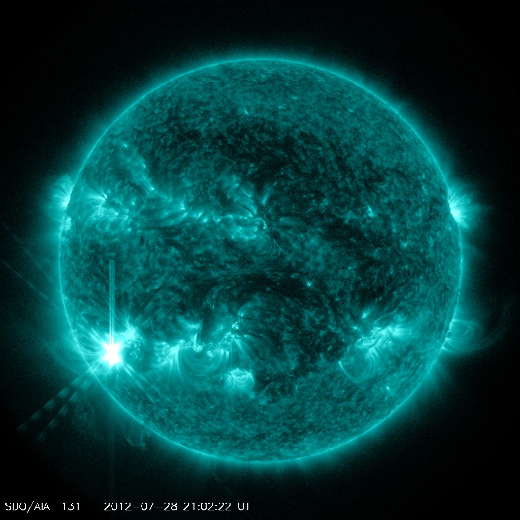
SOLAR ACTIVITY PICKS UP: Sunspot AR1532 is crackling with M-class solar flares. The latest, an M6-class eruption on July 28th (2056 UT), produced a bright flash of extreme ultraviolet radiation, shown here in a snapshot from the Solar Dynamics Observatory:


Update: Contrary to earlier reports, this explosion did produce a CME and the cloud is heading for Earth. According to a forecast track prepared by analysts at the Goddard Space Weather Lab, the CME will reach our planet on July 31st at 1500 UT (+/- 7 hours). Weak to moderate geomagnetic storms are possible when the cloud arrives.


Pick of The Week


FLARE AND PROTON EVENT (JULY 27, 2012)

C2: Quicktime (large) (8.2M), Quicktime (small) (731K), MP4 (2.6M), M4V (879K) 
Magnetic active region 1520-1521 erupted again (July 19, 2012) at the edge of the Sun, this time producing an M7-class flare that almost crossed the threshold into X-territory (largest). Associated with the flare was a coronal mass ejection observed by SOHO's two coronagraphs. The small, white particles splattering the CCD for hours after the eruption are high-energy protons moving at half the speed of light. The front edge of the mass ejection was clocked at over 2 million miles an hour.

Super-sized Loops

Super-sized Loops
Magnetic field lines between two active regions extended across about one-third of the Sun to make their connections (July 23-24, 2012). The magnetically powerful active regions were just rotating into view, giving us a wonderful profile of their activity. The lower active region also spurts out several bursts of plasma as well. The looping arcs above each active region shows off the field lines nicely too. The video clip covers about 36 hours of activity in extreme ultraviolet light.

Thursday, June 14, 2012

Space Weather & Earthquake Update. Solar Flare Activity.

UPDATE
ANOTHER CME: On June 14th, for the second day in a row, sunspot AR1504 erupted and hurled a CME toward Earth. The fast-moving (1360 km/s) cloud is expected to hit our planet's magnetic field on June 16th at 14:00 UT, possibly sparking a geomagnetic storm. High-latitude sky watchers should be alert for auroras


THERE HAVE BEEN TWO M1 FLARES IN A ROW.


THERE IS A 60% CHANCE THAT THERE WILL BE MORE M-CLASS FLARES IN THE NEXT 24-48 HOURS.


----------------END UPDATE------------------


Here is your www.spaceweather.com space weather forecast...

Solar wind
speed: 375.3 km/sec
density: 3.1 protons/cm3

Updated: Today at 0234 UT

X-ray Solar Flares
6-hr max: C6 
1926 UT Jun13 
24-hr: M1 
1319 UT Jun13 

Updated: Today at: 2359 UT


Daily Sun: 13 Jun 12

Sunspot 1504 poses a growing threat for 
Earth-directed M-class solar flares. Credit: SDO/HMI


Coronal Holes: 13 Jun 12

There are no large coronal holes on the Earthside of the sun. Credit: SDO/AIA.


SPACE WEATHER
NOAA Forecasts


Updated at: 2012 Jun 13 2200 UTC
FLARE
0-24 hr
24-48 hr
CLASS M
60 %
60 %
CLASS X
05 %
05 %
The above has all been from www.spaceweather.com What will happen when the new coronal mass ejection glances Earth? Right now, there seems to be a quiet level of earthquake activity (as you can see from the pic below from the USGS). It should be interesting to watch this in the next few days to see if the magnetic disturbance from the geomagnetic storm that will hit with the CME will cause an increase in the pull on the Earth enough to cause some major earthquake activity.


Again, the above graphic is from the USGS site. Below, you will find more information on the incoming CME. This information is from www.spaceweather.com.


CME TARGETS VENUS, EARTH MARS: Active sunspot AR1504 erupted on June 13th at 1319 UT, producing a long-duration M1-flare and hurling a CME into space. According to analysts at the Goddard Space Weather Lab, the cloud will deliver a glancing blow to three planets: Venus on June 15th, Earth on June 16th, and Mars on June 19th. This animation shows the likely progression of the cloud:
NOAA forecasters estimate a 25% - 30% chance of geomagnetic storms when the cloud reaches Earth. High-latitude sky watchers should be alert for auroras.

Sunday, June 3, 2012

Massive Solar Coronal Holes Shaped Like A Chicken Creating Solar Wind.


Space Weather Real Time Image Gallery 

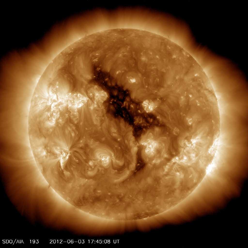
'CH' STANDS FOR ... CHICKEN? A big dark hole in the sun's atmosphere, a 'coronal hole', is turning toward Earth spewing solar wind. According to NASA's official rubber chicken, it looks an awful lot like a bird:
Coronal holes are places where the sun's magnetic field opens up and allows the solar wind to escape. A chicken-shaped stream of solar wind flowing from this coronal hole will reach Earth on June 5th - 7th, possibly stirring geomagnetic storms. High-latitude sky watchers should be alert for auroras.

Solar wind
speed: 410.5 km/sec
density: 1.2 protons/cm3
explanation | more dataUpdated: Today at 1956 UT
X-ray Solar Flares
6-hr max: M3 
1755 UT Jun03 
24-hr: M3 
1755 UT Jun03 
explanation | more dataUpdated: Today at: 2000 UT