10/27/2012 10:24 PM US superstorm threat launches mass evacuations
ALLEN G. BREED
SHIP BOTTOM, N.J. (AP) — Forget distinctions like tropical storm or hurricane. Don't get fixated on a particular track. Wherever it hits, the rare behemoth storm inexorably gathering in the eastern U.S. will afflict a third of the country with sheets of rain, high winds and heavy snow, say officials who warned millions in coastal areas to get out of the way.
"We're looking at impact of greater than 50 to 60 million people," said Louis Uccellini, head of environmental prediction for the National Oceanic and Atmospheric Administration.
As Hurricane Sandy barreled north from the Caribbean — where it left nearly five dozen dead — to meet two other powerful winter storms, experts said it didn't matter how strong the storm was when it hit land: The rare hybrid storm that follows will cause havoc over 800 miles from the East Coast to the Great Lakes.
"This is not a coastal threat alone," said Craig Fugate, director of the Federal Emergency Management Agency. "This is a very large area."
President Barack Obama was monitoring the storm and working with state and locals governments to make sure they get the resources needed to prepare, administration officials said.
New Jersey Gov. Chris Christie declared a state of emergency Saturday as hundreds of coastal residents started moving inland and the state was set to close its casinos. New York's governor was considering shutting down the subways to avoid flooding and half a dozen states warned residents to prepare for several days of lost power.
Sandy weakened briefly to a tropical storm early Saturday but was soon back up to Category 1 strength, packing 75 mph winds about 305 miles south-southeast of Cape Hatteras, N.C., as of 11 p.m. Forecasters said the storm was spreading tropical storm conditions across the coastline of North Carolina, and they were expected to move up the mid-Atlantic coastline late Sunday. Experts said the storm was most likely to hit the southern New Jersey coastline by late Monday or early Tuesday.
Governors from North Carolina, where heavy rain was expected Sunday, to Connecticut declared states of emergency. Delaware ordered mandatory evacuations for coastal communities by 8 p.m. Sunday.
Christie, who was widely criticized for not interrupting a family vacation in Florida while a snowstorm pummeled the state in 2010, broke off campaigning for Republican presidential nominee Mitt Romney in North Carolina on Friday to return home.
"I can be as cynical as anyone," the pugnacious chief executive said in a bit of understatement Saturday. "But when the storm comes, if it's as bad as they're predicting, you're going to wish you weren't as cynical as you otherwise might have been."
The storm forced the presidential campaign to juggle schedules. Romney scrapped plans to campaign Sunday in the swing state of Virginia and switched his schedule for the day to Ohio. First lady Michelle Obama canceled an appearance in New Hampshire for Tuesday, and Obama moved a planned Monday departure for Florida to Sunday night to beat the storm. He canceled appearances in Northern Virginia on Monday and Colorado on Tuesday.
In Ship Bottom, just north of Atlantic City, Alice and Giovanni Stockton-Rossini spent Saturday packing clothing in the backyard of their home, a few hundred yards from the ocean on Long Beach Island. Their neighborhood was under a voluntary evacuation order, but they didn't need to be forced.
"It's really frightening," Alice Stockton-Rossi said. "But you know how many times they tell you, 'This is it, it's really coming and it's really the big one' and then it turns out not to be? I'm afraid people will tune it out because of all the false alarms before ... (but) this one might be the one."
A few blocks away, Russ Linke was taking no chances. He and his wife secured the patio furniture, packed the bicycles into the pickup truck, and headed off the island.
What makes the storm so dangerous and unusual is that it is coming at the tail end of hurricane season and the beginning of winter storm season, "so it's kind of taking something from both," said Jeff Masters, director of the private service Weather Underground.
Masters said the storm could be bigger than the worst East Coast storm on record — the 1938 New England hurricane known as the Long Island Express, which killed nearly 800 people. "Part hurricane, part nor'easter — all trouble," he said. Experts said to expect high winds over 800 miles and up to 2 feet of snow as far inland as West Virginia.
And the storm was so big, and the convergence of the three storms so rare, that "we just can't pinpoint who is going to get the worst of it," said Rick Knabb, director of the National Hurricane Center in Miami.
Officials are particularly worried about the possibility of subway flooding in New York City, said Uccellini.
New York Gov. Andrew Cuomo told the Metropolitan Transportation Authority to prepare to shut the city's subways, buses and suburban trains by Sunday, but delayed making a final decision. The city shut the subways down before last year's Hurricane Irene, and a Columbia University study predicted that an Irene surge just 1 foot higher would have paralyzed lower Manhattan.
Up and down the Eastern Seaboard and far inland, officials urged residents and businesses to prepare in big ways and little.
On Saturday evening, Amtrak began canceling train service to parts of the East Coast, including between Washington, D.C., and New York. Airlines started moving planes out of East Coast airports to avoid damage and adding flights out of New York and Washington on Sunday in preparation for flight cancellations on Monday.
The Virginia National Guard was authorized to call up to 500 troops to active duty for debris removal and road-clearing, while homeowners stacked sandbags at their front doors in coastal towns. At a Home Depot in Virginia Beach, employee Dave Jusino said the store was swamped with customers.
"We have organized chaos, is what I call it," Jusino said. "We organize a group of 10 associates, give them certain responsibilities and we just separate the lines, organize four customers at a time, load up their cars and get them out the door and then take the next customers."
Utility officials warned rains could saturate the ground, causing trees to topple into power lines, and told residents to prepare for several days at home without power. "We're facing a very real possibility of widespread, prolonged power outages," said Ruth Miller, spokeswoman for the Pennsylvania Emergency Management Agency.
Warren Ellis, who was on an annual fishing pilgrimage on North Carolina's Outer Banks, didn't act fast enough to get home. Ellis' 73-year-old father managed to get off uninhabited Portsmouth Island near Cape Hatteras by ferry Friday. But the son and his camper got stranded when high winds and surf forced the ferry service to suspend operations Saturday.
"We might not get off here until Tuesday or Wednesday, which doesn't hurt my feelings that much," said Ellis, 44, of Amissville, Va. "Because the fishing's going to be really good after this storm."
Last year, Hurricane Irene poked a new inlet through the island, cutting the only road off Hatteras Island for about 4,000.
In Connecticut, the Naval Submarine Base in Groton prepared to install flood gates and pile up sandbags to protect against flooding while its five submarines remain in port through the storm.
Lobsterman Greg Griffen in Maine wasn't taking any chances; he moved 100 of his traps to deep water, where they are less vulnerable to shifting and damage in a storm.
"Some of my competitors have been pulling their traps and taking them right home," said Griffen. The dire forecast "sort of encouraged them to pull the plug on the season."
In Muncy Valley in northern Pennsylvania, Rich Fry learned his lesson from last year, when Tropical Storm Lee inundated his Katie's Country Store.
In between helping customers picking up necessities Saturday, Fry was moving materials above the flood line. Fry said he was still trying to recover from the losses of last year's storm, when he estimates he lost $35,000 in merchandise.
"It will take a lot of years to cover that," he said.
Christie's emergency declaration will force the shutdown of Atlantic City's 12 casinos for only the fourth time in the 34-year history of legalized gambling here. The approach of Hurricane Irene shut down the casinos for three days last August.
Atlantic City officials said they would begin evacuating the gambling hub's 30,000 residents at noon Sunday, busing them to mainland shelters and schools.
Tom Foley, Atlantic City's emergency management director, recalled the March 1962 storm when the ocean and the bay met in the center of the city.
"This is predicted to get that bad," he said.
Eighty-five-year-old former sailor Ray Leonard said if he had loved ones living in the projected landfall area, he would tell them to leave. Leonard knows to heed the warnings.
He and two crewmates in his 32-foot sailboat, Satori, rode out 1991's infamous "perfect storm," made famous by the Sebastian Junger bestseller of the same name, before being plucked from the Atlantic off Martha's Vineyard, Mass., by a Coast Guard helicopter.
"Don't be rash," Leonard said in a telephone interview Saturday from his home in Fort Myers, Fla. "Because if this does hit, you're going to lose all those little things you've spent the last 20 years feeling good about."
___
Breed reported from Raleigh, N.C. Contributing to this report were AP Science Writer Seth Borenstein in Washington; Emery Dalesio in Kill Devil Hills, N.C.; Karen Matthews in New York; Glenn Adams in Augusta, Maine; Randall Chase in Lewes, Del.; Rodrique Ngowi in Boston; Ron Todt in Philadelphia and Nancy Benac in Washington.
POSTED AT 10:01 AM ON OCTOBER 27, 2012 BY JAZZ SHAW
Out in our neck of the woods, people are bracing for yet another autumn storm, stocking up on water, batteries and sundry supplies, hitting the ATM and what have you. (And as a note to meteorologists, if you’re calling something a “century flood” and it happens four times in ten years, you may want to recheck your math.) But the only reason we’re able to scramble and put preparations in place is that we’ve had nearly a week’s advance notice of the coming storm, with predictions of Sandy’s trackgetting more precise by the day. But is this type of data going to be available to us in the future?
One report claims that our NOAA weather satellites are in danger of dying off before replacements can be put on station, leaving us without the tracking information current weather models rely on.
The United States is facing a year or more without crucial satellites that provide invaluable data for predicting storm tracks, a result of years of mismanagement, lack of financing and delays in launching replacements, according to several recent official reviews.
The endangered satellites fly pole-to-pole orbits and cross the Equator in the afternoon, scanning the entire planet one strip at a time. Along with orbiters on other timetables, they are among the most effective tools used to pin down the paths of major storms about five days ahead.
At The Atlantic, Rebecca Rosen asks and answers the question, what would happen if we didn’t have this capability anymore?
NOAA recently conducted an experiment to see what the agency would have forecast when 2010′s “Snowmaggedon” struck, had the agency only had buoys and weather balloons. With the lesser data, the models lowballed the snowfall by 10 inches.
In case you still aren’t sure whether this data matters, “polar satellites” Cushman reports, “provide 84 percent of the data used in the main American computer model tracking the course of Hurricane Sandy.”
So the usual bureocratic mismanagement at NOAA has left us with one of our two TIROS-N polar orbiting satellites currently at the end of its predicted lifespan, while the replacement JPSS-1 is essentially still on the drawing board. You can read about the structure of our weather satellite system here. Basically, we have two geosynchronous birds, GOES-13 and GOES-15, which monitor the weather from fixed positions. One of them covers North and South America and the Atlantic basin, while the other watches the Pacific. We also have GOES-12, with only limited capability, which focuses on Central America. But we’ve already launched GOES-14 and it’s parked in orbit, inactive, as the replacement for whichever of 13 or 15 fails first, so we should be OK on that front.
Unfortunately, the real meat of the predictive data comes from the two polar orbiting satellites. (Yes, believe it or not, there are only two.) They circle the Earth from pole to pole, with one crossing the equator in the morning and the other in the afternoon each day. There is no backup in orbit for these yet, and there may not be until 2017 under current plans. Funding for the replacement orbiter is also potentially facing the ax if we go over the fiscal cliff. So there’s one question for us to consider. We’re talking about $182M for the replacement polar orbiting satellites. Is that something we want to give up in the name of fiscal probity? Or would the long term costs of unanticipated storm damage dwarf it?
WikipediaWreckage from the 1900 Galveston hurricane floats offshore.
On September 4, 1900, the U.S. Weather Bureau office in Galveston, Texas, learned of a major storm in Cuba. It was hard to predict where it might head next; they apparently thought it was likely to head northeast. It didn’t. On the 8th, a hurricane leveled the city.
The Galveston Weather Bureau staff didn’t have much choice but to guess. As we’ve seen with Sandy over the past few days, the path of a hurricane is hard to predict even with modern sensor technology and satellites. Without the data we now collect, almost as blind as Texans in 1900.
And now the bad news: Obsolescence and budget cuts may mean that we’re about to lose some of those data-collecting satellites. From The New York Times:
The endangered satellites fly pole-to-pole orbits and cross the Equator in the afternoon, scanning the whole planet one strip at a time. Along with orbiters on other timetables, they are among the most effective tools used to pin down the paths of major storms around five days ahead.
All this week, forecasters have been relying on just such satellite observations for almost all of the data needed to narrow down what were at first widely divergent computer models of what Hurricane Sandy would do next: explode against the coast, or veer away into the open ocean?
Experiments show that without this kind of satellite data, forecasters would have underestimated by half the massive snowfall that hit Washington in the 2010 blizzard nicknamed “Snowmageddon.”
The more data, the more predictions can be made. As noted above, path isn’t the only important issue. There’s strength, ocean temperatures, and other contributing weather patterns like those making Sandy so scary.
How’d we get to this state? As we’ve noted before: mismanagement, starting a decade ago.
This summer, three independent reviews — by the Commerce inspector general, the Government Accountability Office, and a blue-ribbon team of outside experts — each questioned the government’s cost estimates for the program, criticized the program’s managers for not pinning down the designs and called for urgent remedies. The project is run by Commerce’s National Oceanic and Atmospheric Agency, along with NASA. …
In response, top Commerce and NOAA officials on Sept. 18 ordered what they called an urgent restructuring — just the latest overhaul of a program that has been troubled for many years.
Last year, the NOAA launched a satellite, Suomi, meant to fill some of the data-collection gaps.
But there are lingering concerns that technical glitches have shortened Suomi’s useful lifetime, perhaps to just three years. Predicting a satellite’s lifetime is like guessing when a light bulb go out. The most likely timing of a gap in coverage is between 2016 and 2018, according to the best official estimates.
That would “threaten life and property,” the independent review team warned.
Someday, people will look back at this era of weather prediction and see it as hopelessly ignorant, unable to predict precise paths and effects weeks in advance. We’re doing better than they were 112 years ago in Galveston. It’s frightening to think we may be doing worse in five years.
update 8-15-2012 Well, I don't know about the megaquake event predictions, but earthquake activity is increasing again. Not necessarily around Chile, but increasing non-the-less, so I thought I'd share this with you that may help explain the quake in Chile...
2,300 birds found dead along Chilean beaches
From Marilia Brocchetto, CNN
updated 3:13 AM EDT, Sat May 12, 2012
Wildlife engineer Guillermo Boigorria, left, and regional prosecutor Lev Castro inspect sea bird in Peru, which along with Chile has seen a rash of water bird deaths.
(CNN) -- Chilean officials are asking fishermen to help save birds caught in nets after thousands of dead fowl appeared along coastal Chile this week.
At least 2,300 dead birds were found along beaches between Cartagena and Playa de Santo Domingo, Chile, said Jose Luis Britos, and environment professor and director of the Museum of Natural History of San Antonio, Chile.
Many of the birds, which come from several species, had broken wings and bruising on the outside of their bodies -- injuries consistent with getting trapped in fishing nets, Britos said.
He said bird deaths from fishing nets occur every year, but never at this level. In a typical year, about 15 to 20 dead birds are found, Britos said.
Dying pelicans in Peru have been blamed on warm waters.
One hypothesis for the increase this year involves climate. As Chilean weather gets colder this time of year, migrating birds that would normally travel north for warmth are instead lingering to feast on an influx of anchovies and sardines that had fled the coast of Peru in search of cooler waters.
Earlier this week, Peruvian authorities say warm waters off that country's coast are to blame for the deaths of more than 5,000 marine birds.
The Peruvian National Center for the Study of El Nino said that since February, the Peruvian coast has had an abundance of warm water as a result of marine currents throughout the world's oceans. The warm water has altered the marine ecosystem, it said.
The warm water has led fish such as anchovies and other species that live in surface waters to migrate to deeper water toward the south. As a result, pelicans and other birds that feed from the surface of the water died of starvation.
"If these oceanographic conditions persist, it is likely that its impact will spread to other areas of the (Peruvian) coast even during the fall, which could make the numbers increase and affect other marine species," the report stated.
The Peruvian ministry of environment said seafood is still safe to eat, and encouraged everyone to continue to support local fishermen, according to state-run Andina news agency.
Officials in Peru continue to search for the cause of death of almost 900 dolphins since the beginning of the year. The health ministry is awaiting final results from molecular analysis looking for the morbillivirus, which previously has been linked to dolphin deaths.
The Chilean agriculture and livestock ministry and staff from Britos' center have called for a meeting with fishermen for Monday. They are asking fishermen to try to save trapped birds before closing their nets.
Britos said he worries that until Monday, the number of dead birds could rise significantly.
Study yields insights on how natural disasters can affect life and effect of rising sea level
Mario Manzano
This uplifted rocky shore shows mortality of marine life after the 2010 Chile quake.
By Charles Q. Choi
OurAmazingPlanet
updated 5/7/2012 5:32:28 PM ET
The earthquake and tsunami that rocked Chile in 2010 unleashed substantial and surprising changes on ecosystems there, yielding insights on how these natural disasters can affect life and how sea level rise might affect the world, researchers say.
The magnitude 8.8 earthquake that hit Chile struck off an area of the coast where 80 percent of the population lives. The massive quake triggered a tsunami reaching about 30 feet (10 meters) high that wreaked havoc on coastal communities : It killed more than 500 people, injured about 12,000 and damaged or destroyed at least 370,000 houses.
It makes sense that such earthshaking catastrophes would have drastic consequences on ecosystems in the affected areas. However, if researchers lack enough data about the environment before a disaster strikes, as is usually the case, it can be difficult to decipher these effects. With the 2010 Chile quake, scientists were able to conduct an unprecedented report of its ecological implications based on data collected on coastal ecosystems shortly before and up to 10 months after the event.
Eduardo Jaramillo
A beach before (top) and after (bottom) the 2010 Chile earthquake. The uplift the beach experienced created habitat that intertidal species rapidly colonized.
The sandy beaches of Chile apparently experienced significant and lasting changes because of the earthquake and tsunami. The responses of ecosystems there depended strongly on the amount of land level change, how mobile life there was, the type of shoreline and the degree of human alteration of the coast. For instance, in places where the beaches sank and did not have manmade sea walls and other artificial "coastal armoring" to keep water out, intertidal animal populations — ones living in the part of the seashore that is covered at high tide and uncovered at low tide — all dropped, presumably because their habitats were submerged.
The most unexpected results came from uplifted sandy beaches. Previously, intertidal species had been kept from these beaches due to coastal armoring. After the earthquake, these species rapidly colonized the new stretch of beach the quake raised up in front of the sea walls.
"This is the first time this has been seen before," said researcher Eduardo Jaramillo, a coastal ecologist at the Southern University of Chile.
"Plants are coming back in places where there haven't been plants, as far as we know, for a very long time," said researcher Jenny Dugan, a biologist at the University of California, Santa Barbara. "This is not the initial ecological response you might expect from a major earthquake and tsunami."
Chilean coastal town after the 2010 tsunami: Marcelo Caro via Wikimedia Commons
Chile's 8.8 earthquake and tsunami of 2010 caused massive devastation, not least along its coastline, with some beaches subsiding and losing biodiversity, and some rocky reefs uplifting and losing biodiversity—as you might expect.
But thanks to the investigations of a science team already looking at the ecology of Chile's sandy beaches before the quake, we now know this natural disaster also engineered some powerful and unexpected forms of coastal restoration.
This occurred where the temblor uplifted coastlines with coastal armouring—like seawalls and rocky revetments—which allowed those once-disappearing beaches to quickly grow where they had not grown in a long time, and allowed plants and other species to reinhabit places they hadn't inhabited in a long time.
The study, just published in the open-access PLoS ONE, also previews the types of changes we might expect from climate warming and its accompanying sea level rise.
Photos of study sites taken before and after the 2010 Chile earthquake: Eduardo Jaramillo, et al. PLoS ONE. DOI:info:doi/10.1371/journal.pone.0035348.g001
In the before-and-after disaster above the orange dotted lines indicate 24 hour spring high tide line. You can see that dry sandy areas above the high tide line dwindled where beaches that subsided (a) and increased where beaches uplifted (b, c and d). These changes were affected by whether or not coastal armoring was in place. Specifically:
a–b show unarmored sites (a: where land subsided and the beach grew narrower after the quake; b: where coastal uplift made the beach wider afterwards)
c–d show armored sites (c: where uplifted wider intertidal occurs in conjunction with a seawall; d: where uplifted wider intertidal occurs in conjunction with a revetment)
e–f show relationships between the magnitude of land-level changes (e: shows beach widths; f: shows beach face slopes—red dots=sites with seawalls; blue dots=sites with rocky revetments; black dots=unarmored sites)
Land level changes from the 2010 Chile earthquake, epicenter yellow star: Eduardo Jaramillo, et al. PLoS ONE. DOI:info:doi/10.1371/journal.pone.0035348.g001
"So often you think of earthquakes as causing total devastation, and adding a tsunami on top of that is a major catastrophe for coastal ecosystems," says co-author Jenny Dugan, at UCSB. "As expected, we saw high mortality of intertidal life on beaches and rocky shores, but the ecological recovery at some of our sandy beach sites was remarkable. Plants are coming back in places where there haven't been plants, as far as we know, for a very long time. The earthquake created sandy beach habitat where it had been lost. This is not the initial ecological response you might expect from a major earthquake and tsunami."
----------------------------end update-------------------------------- Glimpse of the line of earthquakes along the fault that connects the Mexico earthquake and the Chile earthquake. Movement is definitely happening. How much is this moving the continent and the poles?
Alert...First the 7.9 (7.8, 7.4, or whatever it wound up being, depending on who you talk with) in Mexico and now a 7.1 earthquake in Chile.
Major quake rattles Chile but no serious damage
By Alexandra Ulmer
SANTIAGO | Sun Mar 25, 2012 9:24pm EDT
(Reuters) - A major quake hit central Chile on Sunday, rattling buildings in the capital and triggering a coastal evacuation, but there was no serious damage and big mines in the world's No. 1 copper producer were operating normally.
Residents in Santiago fled their homes as the tremor rattled television sets, kitchen cabinets and tables, and a mayor in the town of Parral in south-central Chile told local radio a 74-year-old woman died of a heart attack due to the quake. There were no other immediate reports of serious casualties.
The 7.1 magnitude quake struck 16 miles north northwest of the town of Talca at a depth of 22 miles, the U.S. Geological Survey said, revising down an initial magnitude of 7.2.
It was one of the strongest quakes to hit Chile since a massive 8.8 temblor devastated the south-central region in early 2010, which triggered ensuing tsunamis, killed about 500 people and hammered roads and infrastructure.
"So far there are no fatalities reported. There is evidence some people were injured, but not badly," Interior Minister Rodrigo Hinzpeter said, adding that electricity supply had been restored after disruptions in some areas.
"This event did not produce nor will it produce a tsunami on our country's coast," Hinzpeter added.
However, a government official later said there were signs the sea had retreated a bit, and the emergency office reordered a coastal evacuation in the Mauler coastal region as a preventive measure.
The government emergency agency, ONEMI, said two people were injured after the fake ceiling of a church in Santiago collapsed and one person suffered injuries from a transit accident in the Biobio region.
With the memory of the 2010 quake still seared into their memories, many Chileans were visibly shaken up.
"I was watching television and all of a sudden the sofa started to move, and lamps started to swing from one side to the other," said Guild Carrack. "It just kept moving and didn't stop. It was very strong."
Chilean state copper giant Codelco said after the quake that operations were normal at its Andina mine and its El Teniente deposit, which is located nearer the epicenter. Together, the two mines produce about 635,000 tonnes of copper annually.
Global miner Anglo American said its Lost Bronzes copper mine in central Chile was operating normally, and the country's top oil refinery, Bios Bios, also said operations were normal after the tremor.
The central area is home to some important copper mines, but the bulk of output in the world's top copper exporting nation is concentrated in the far north.
Quakes of magnitude 7.0 or above are capable of causing major damage. The 2010 quake caused roughly $8 billion in insured losses and economic losses of at least twice that.
In the last two years earthquakes have been a scourge of the insurance industry. In addition to Chile, 2011 quakes in Japan and New Zealand caused record-breaking losses in the tens of billions of dollars.
More recently, a major earthquake in Mexico caused limited losses, disaster modeling agencies said, given that it happened well away from major population centers.
27 km (16 miles) NNW of Talca, Maule, Chile 55 km (34 miles) WSW of Curico, Maule, Chile 99 km (61 miles) NNE of Cauquenes, Maule, Chile 219 km (136 miles) SSW of SANTIAGO, Region Metropolitana, Chile
-------------end update------------- Here is an update on this post. Again, remember this is not a guarantee of anything. Also remember, that the math used is an estimate, so do keep looking for a MEGAQUAKE situation for the next week.
In my opinion, the cause of these shifts is a massive celestial object moving inward from the 9 o'clock orientation of the solar system/ springtime/ constellations Leo-Orion.
The effects on the planet are directly correlated to Earth's orientation relative to the massive object, with shifts of Earth's axis occuring every 377 days, and significant Earthquakes every 188-9 days.
There is a chance the shift could occur later, IF the celestial object makes entry into the inner solar system, thus changing it's orientation relative to Earth. But there is no way to determine this without an infrared telescope and trained astronomers, of which, only the elites have access to, and they have developed a policy of secrecy on the topic. So information is hard to come by. SOURCE: GLOBAL RUMBLINGS -----------------------------------------------
Quote:TheFreeAdviceMan
IT IS ALLEGED THAT: During the Reagan Administration a group of global Scientists, comprised mostly of American, Canadian and Scandinavian nationals, delivered a report to the WH that suggested danger from cyclical eruptions of world's Super-Volcanoes that would cause a Mass Extinction Event in the near future. In 1984 construction of various underground facilities, including the Global Seed-Bank in Svaalbard, Norway and the first construction on The Denver Airport Underground Super-Facility in Colorado began. During the first year of the first Bush Administration G. H.W. Bush a Top Secret report was delivered to the WH and NSC by a group of Geologists and Meteorologists associated with USGS and NOAA in which thy provided confirmation of the following:
A highly complex series of cyclical events including Cyclical Solar Radiation Cyclical Earth Atmospheric Weather Changes affecting Tropospheric, Biospheric and Geo-spheric chemical and compositional changes affecting Global Temperature, and triggering events that will lead to massive melting of the Glaciers, polar Ice-caps, release of deep-sea stored Methane, causing dramatic changes in Salinity Levels, leading to both major Tidal Anomalies and slowing/reversal of Thermohaline Circulations, leading to increased grinding of Plate Tectonics, leading to increased Seismic Activity and ultimate to Eruptions of World's major Super-Volcanoes ! Hence potential/probable MASS EXTINCTION EVENT!
A year later, following the recommendations of this select panel, the Federal Government, established H.A.A.R.P. as a way to reduce the 'friction' (grinding) on American-related plates (as well as conduct other 'useful' activities) in an effort to mitigate eruption of the Super-Volcano at Yellowstone! This technology has since been sold to Japan, China and Norway, in exchange for joint efforts intended to provide a selected number of people to survive. The Russians have also worked on their own facilities, as have the Australians and Argentinians.
The next Super-Volcanic Eruption Cycle is likely any day now and definitely within the next 30 years. Contrived Global Economic Crisis are used in order to mask what is nothing less than Grand Theft on the part of THOSE IN THE KNOW WHO HAVE ACCESS TO THESE SURVIVAL FACILITIES. It is estimated that the total capacity of all such M.E.E. survival facilities is around 500,000 of which most are in the USA, CHINA and NORWAY. Mind you: this is all ALLEGED and NO DIRECT EVIDENCE IS PROVIDED by any source(s). SOURCE: REALIST NEWS-----------------------------------------------------
The big earthquakes that have struck in some areas around the world in the past couple of years have been found to follow a pattern, allowing one to predict when the next mega quake is coming. The pattern is being called the 188-day cycle and it says that a powerful quake occurs every 188 days. It predicts that an 'event' is likely to take place on or around March 22, 2012.
March 22, 2012 Earthquake (Mega Quake Prediction)
Here's an illustration of the said earthquake cycle: February 28th, 2010: An 8.8-magnitude rocked Chile. 188 days later, September 4th, 2010: A magnitude 7.1 earthquake jolted Christchurch, New Zealand. 188 days later, March 11th, 2011: Japan was devastated by a 9.0-magnitude quake. 188 days later, September 15th, 2011: 6.0-, 6.2-, and 7.3-magnitude earthquakes struck New Zealand, Japan and Fiji, respectively. 188 days later, March 22, 2012: Another mega quake?
Experts, however, argue that it is impossible to predict an earthquake. "Although it is understood that most earthquakes will concentrate at plate boundaries, there is no reliable method of accurately predicting the time, place, and magnitude of an earthquake.Earthquakes are difficult or impossible to predict because of their inherent randomness and near-chaotic behavior," the Pacific Disaster Center said. SOURCE: noypistuff
-------------------------
-----------------------------------------
March 22: Megaquake Warning!
ALL MAJOR NEWS OUTLETS are being sent a copy of this Press Release stating that everyone living on or near a seismic zone should be warned to brace for one of the top five earthquake events in recorded history on March 22, 2012 at 4:58:34 UTC.
St. Petersburg, Florida—Our researchers have discovered a pattern of seismicity going back to 1965 that has transitioned into large magnitude events including Earth axis shifts on a regular 188-day cycle. The most-recent events include the Feb 27, 2010 8.8 event in Chile, the Sept 4, 2010 7.1 event at Christchurch, New Zealand, the Sept 15, 2011 7.3 event in Fiji and the March 11, 2011 9.0 Japan event. According to our calculations the next event is expected to take place on March 22, 2012 at 4:58:34 UTC, when Earth will pass through the gravity trough connecting the Sun and a heavy-mass object (HMO) being tracked out of the Leo Constellation. The Earth’s axis is expected to shift five to six inches, like the four-inch shift with Japan event and the three-inch shift with the Chile event.
I have been sending warning messages to the media all along and nobody has responded with a single word. We shall see very soon if the next ‘event’ on the 188-day cycle is for real or not. My hands are clean and everyone has the opportunity to be warned… Uploaded by TerralO3 on Mar 18, 2012 | Press Release Link: terral03.com | USGS Latest earthquakesSOURCE: EXOHUMAN.COM----------------------------------------
-----------end update----------------------------- Here is an update with a bit more information...again, I cannot guarantee anything, but it is interesting...
March 22, 2012 Event
March 22, 2012 is the day our researchers expect that Earth axis will shift 5 inches with aquifers around the globe and a 9+ magnitude earthquake event that will likely be included among the top ten in Earth history. This marks the next day on the 188-Day Cycle that is part of a pattern of seismicity extending back to 1965 (Mensur Omberbashich April 11, 2012 to Cornell). Other events on the 188-day cycle took place on February 27, 2010 (Chile 8.8*), September 4, 2010 (Christchurch 7.1*), March 11, 2011 (Japan 9.0*) and September 15, 2011 (Fiji 7.3*). The Earth experienced Earth axis shifts of three inches and four inches respectively with the nearside alignments and earth aquifer shifts connected to the Chile and Japan events. The historical precedent established by this seismic event pattern says the next Earth axis shift will take place in March 22, 2012 and will be five inches or greater.
The 188-Day diagram shows how Earth orbit relative to the inbound heavy-mass object is broken down into four parts. Recently Earth reached outside orbit position over on the winter side of the solar system from the northern hemisphere perspective. That marks the time that the heavy-mass object in the Leo/Virgo Constellations appeared to stop moving into Virgo to begin retracing a path back into the Leo Constellation from Earth orbit perspective. While the inbound star is actually coming in for an orbit around the Sun, remember that Earth is orbiting back and forth at a distance of two astronomical units from the winter to summer side of the solar system. That means the inbound heavy-mass object appears to be moving back and forth against the backdrop of the Leo to Virgo Constellations from our earthbound perspective.
Earth reached outside orbit position on December 18, 2011 to begin the first half of 6-month near orbit to the Leo Constellation, or the first quarter of the orbit cycle for 2012. This marks the time that the magnetic portal connection begins to shorten for a higher percentage of internal conduits to become active, which allows the inbound star to inject increased levels of magnetism into the Earth. The magnetite deposits inside the Earth receive that magnetism for conversion into heat energy, which causes the Earth core to heat up Earth magma. This also means the magnetosphere fluctuations increase to cause a twisting of magnetic lines, which causes migrating animals with magnetite in their tissues to migrate east and west rather than north and south and lose their way. We should expect to see increased volcanism, earthquake activity and mass migrating animal deaths through the first three months of 2012 on way to the March 22, 2012 Alignment/Earth axis Shift Event.
Hey everyone. Here is some more information regarding this prediction that I've picked up from the Net. Remember what I said in my previous post...it's the Internet so take this information for what it is...I cannot vouch for it, but I find it interesting. From IRAQI DINAR RUMORS.com
March 3 – 2012Two strong alignments involving (Sun-Earth-Mars) and (Venus-Mercury-Sun) as well as significant astrological aspects involving the moon which may represent a possible 6.8 Magnitude earthquake on one of these days.Lunar modulation indicates the pacific island region could be the area that receives this event. Best mapped location:Gujarat, India or Pakistan.. videoMarch 21/22 – 2012Two very strong alignments involving (Sun-Earth-Mercury-Uranus) and (Mars-Earth-Neptune) as well as significant astrological aspects involving the moon which may represent a possible 8.0 Magnitude earthquake on one of these days.Lunar modulation indicates the pacific island region could be the area that receives this event. Best mapped location:Aleutian Islands, Alaska.Analysis using Heliocentric Imagery, geocentric portrait and harmonic translations to predict possible effects here on earth. Using astrology in this forecast in-conjunction with lunar modulations. thebarcarollerAstrologer Contact InformationAlandra – Alandra@iinet.net.auPhillippa – phillyc@xtra.co.nzSolar System Scope Websitehttp://www.solarsystemscope.com/Swiss Ephemeris Informationhttp://www.astro.com/swisseph/ahel/2000/ahel2012.pdfhttp://www.solarmonitor.org/Google EarthExcellent information websites for solar watchers and researchershttp://www.solen.info/solar/http://www.solarmonitor.org/http://sdo.gsfc.nasa.gov/http://helioviewer.org/Earthquake Reporting Channelhttp://www.youtube.com/user/EQReporterSolarwatcher websitehttp://solarwatcher.netSource and author: thebarcaroller (youtube)
Is a Gigantic Mega-Quake in our Future for March 22, 2012?Posted onJanuary 13, 2012January 13, 2012 – Is a Gigantic Mega-Quake in our Future for March 22, 2012?A subscriber posted an intriguing YouTube video, suggesting that an enormous mega-quake was due on March 22, 2012. Below, is a summary of the hypothesis:
A large earthquake occurred on February 27, 2010 in Chile. If you add 188 days to that date, you get September 3, 2010; when a 7.0 magnitude tremor struck New Zealand. Then add 189 days to the NZ quake and you get March 11, 2011; which was the Japan mega-quake and tsunami. Add 189 days to the Japan quake and you get September 15, 2011; which was the date for a 7.3 magnitude Fiji tremor. Then add 189 days to that and you get March 22, 2012; which is a warning for another large quake of unknown magnitude.
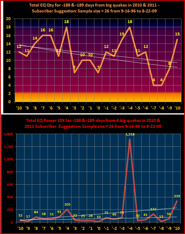
It’s an intriguing video and beautifully done, however, I have my doubts on such a small sample. Therefore, I prepared the two graphs above; based upon my 39 year global earthquake file, including all earthquakes greater than or equal to 6.0 magnitude.
I expanded the sample size to 26, using all the dates between August 22, 2009 and September 16, 1996. The dates were selected by subtracting 189 days from February 27, 2010 (the Chile quake) and arriving at August 22, 2009. I then recorded earthquake quantities and power at a 10X scale, from 10 days before and after that date. I continued this process, alternating between 188 and 189 days, until I arrived at September 16, 1996. The summarized data is above.
The top graphs records the quantity of earthquakes 10 days before “D” day and 10 days after. The two white horizontal lines are a linear and exponential best fit lines. As you can, the data indicates that earthquake quantity decreases from 10 days before to 10 days after, although the quantity is highly variable; with peaks of 18 total quakes four days before and four days after.The picture changes completely, when we look at the power of those earthquakes on a 10X exponential scale. In other words, a 7.0M quake is 10 times stronger than a 6.0 quake but 100 times stronger (10 X 10 = 100) than a 9.0 quake.
As you can see, the power rating peaks very strongly at four days after at a rating of 1,318. This is because that data point includes the Sumatra mega-quake of December 26, 2004. This quake had a power rating of 1,289 and is, therefore, responsible for 97.8% of the 1,318 data point four days after “D” day.
Another very compelling fact is that March 22, 2012 has a New Moon at 2* Aries 22’ (two degrees of Aries and 22 longitude minutes), which goes through (is on the IC) of eastern Australia, western Papua New Guinea and directly through Tokyo. Could this day (March 22nd) be the day the Solar Eclipse of May 20, 2012 manifests?
From The Above Youtube Poster
The historical and geological records say the Earth and particularly the Pacific Ring of Fire will experience a 9+ magnitude quake event on March 22, 2012 @ 4:58:34 UTC where Earth axis is expected to shift 5+ inches. Earth experienced a simlar event on February 27, 2010 and March 11, 2011 and we expect the 188-day Cycle Pattern to continue. Everyone living in a seismic zone should pay careful attention to events transpiring around March 22, 2012 along with people living near the coasts.
The Disaster Center recommends the following…If you are at risk from earthquakes:
Pick “safe places” in each room of your home.
A safe place could be under a sturdy table or desk or against an interior wall away from windows, bookcases, or tall furniture that could fall on you. The shorter the distance to move to safety, the less likely you will be injured. Injury statistics show that persons moving more than 10 feet during an earthquake’s shaking are most likely to experience injury.
Practice drop, cover, and hold-on in each safe place.
Drop under a sturdy desk or table, hold on, and protect your eyes by pressing your face against your arm. Practicing will make these actions an automatic response. When an earthquake or other disaster occurs, many people hesitate, trying to remember what they are supposed to do. Responding quickly and automatically may help protect you from injury.
Practice drop, cover, and hold-on at least twice a year.
Frequent practice will help reinforce safe behavior.
Talk with your insurance agent.
Different areas have different requirements for earthquake protection. Study locations of active faults, and if you are at risk, consider purchasing earthquake insurance.
Inform guests, babysitters, and caregivers of your plan.
Everyone in your home should know what to do if an earthquake occurs. Assure yourself that others will respond properly even if you are not at home during the earthquake.
Get training.
Take a first aid class from your local Red Cross chapter. Get training on how to use a fire extinguisher from your local fire department. Keep your training current. Training will help you to keep calm and know what to do when an earthquake occurs.
Discuss earthquakes with your family.
Everyone should know what to do in case all family members are not together. Discussing earthquakes ahead of time helps reduce fear and anxiety and lets everyone know how to respond.
Do you remember when I posted about SkyQuakes and about the Pole Shift, as well as the increase in earthquake activity and volcanic activity? Now there is a prediction that is supposedly mathematically highly probable regarding HUGE seismic activity, or a MASSIVE seismic event around (some say exactly) March 22, 2012. I'll post some of the videos and posts that show the information on this.
As I post this information, remember that within my posts on SkyQuakes and the trumpet and humming noises that have been heard around the globe that the last time this happened and was recorded, supposedly Mt. Everest was born. So, evidently, we are in for a new global landscape.
I cannot vouch for the truthfulness of all of this information because it IS the Internet and, believe it or not, not everything is true on the Internet:)
I can say that I have watched for patterns in solar flare and other solar activity, as well as earthquake activity and volcanic activity.
The solar activity is increasing and is sending coronal mass ejections that are affecting our magnetosphere and actually squeezing it pretty hard. There have also been instances in which there have been geomagnetic disturbances that have no solar connection and have remained a mystery, but have acted like a coronal mass ejection hitting and squeezing the magnetosphere.
Additionally, there are volcanoes that have been dead for hundreds of years (or longer) that are starting to steam and actually starting to erupt. This has correlated directly with the increase in seismic (or earthquake) activity.
There are now swarms of earthquakes that are larger in size and number and the plates are surely more active than have been recorded prior.
Therefore, I can only tell you to prepare. Even if this date or this particular "mathematical prediction" is not correct, there is enough evidence that tells us all that we need to have an emergency preparedness plan, that is complete and ready at a moments notice, for ourselves and our loved ones. I do know, from relatives in California, that the neighborhoods and churches there are not mincing words when they tell them to prepare for a large earthquake. They are extremely vigilant...more so than they have ever been...about this preparedness.
Here is the information. You may judge it for yourself.
First piece of information...
Link to documentation in California regarding their analysis of the plate movement and the urgency to prepare, as well as some predictions of what is to come... CLICK HERE - CALIFORNIA DOCS - USGS
Workshop on Update of Pacific Northwest Portion of the U.S. National Seismic Hazard Maps
The USGS is convening a workshop on the updating of the Pacific Northwest portion of the U.S. National Seismic Hazard Maps in Seattle on March 21-22. This meeting will discuss the inputs to the earthquake source models and the ground-motion prediction equations (attenuation relations). We will focus on new research results since the 2008 maps. The purpose of this workshop is to hear about these new results and to hear the opinions of scientific experts on how we should use these new results in the next round of the national maps.
Here is a partial list of topics we will discuss: 1. Recurrence models and rupture geometries for great earthquakes on the Cascadia subduction zone 2. New information on crustal faults in Washington and Oregon from geologic mapping, paleoseismology, and geophysics 3. Crustal deformation models using GPS 4. New information about deep intraslab earthquakes 5. Ground-motion prediction equations for great subduction zone earthquakes, intraslab earthquakes, and crustal earthquakes A preliminary agenda can be found here.
Event Date:
Wednesday, March 21, 2012 - 08:30 - Thursday, March 22, 2012 - 15:00
The signs of unrest are showing --- volcanic activity increasing (just like last year before the Japanese massive earthquake) .... global earthquake swarm activity showing obvious signs (again like last year)... and now we're seeing a localized 5.0M+ earthquake swarm in and around Japan proper (just like last year as well).
Put that all together, and you get a REAL POSSIBILITY of another large earthquake off the coast of Japan .... soon (weeks not months)
All areas around the ring of fire, all areas that are KNOWN earthquake prone.. and all areas that ARE NOT earthquake prone... all these areas where people reside -- you need to have a plan and be prepared. We're going to be seeing earthquakes occur in places that don't normally see much earthquake activity ....
Areas like Canada, the northeast USA , midwest and south USA ----- areas like Central Europe , France, Germany, England, Belgium, Netherlands --- be alert as well.
Russia, China, India ---- BE ON HIGH ALERT --- the whole area of Russia/China/India is also showing movement and buildup (the recent 6.8M in siberia for instance plus DOZENS of 5.0M+).
North american Craton as well --- states of Idaho, Wyoming, Montana, Utah, Colorado, New Mexico, Texas, Oklahoma, Arkansas, Missouri, Tennessee, Kentucky, Illinois, Indiana, Georgia, South Carolina, North Carolina, Virginia, West Virginia, and the entire area of New England (connecticut, delaware, maryland, new york, pennsylvania, new jersey, washington DC, Massachusetts, New Hampshire, Rhode Island, Maine, and Ohio (several more states are included in the outskirts of the main craton edge --- basically this puts the ENTIRE USA under a potential earthquake threat in the near term (weeks).
If the activity dies down over the next few weeks, we can all take a deep sigh of relief.. but until things calm down globally.. THE TIME TO PREPARE WAS YESTERDAY !!!! Get your plans together... food, water, clothing, communication, transportation, and self defense ... know the plan and be ready (just in case).
This is a Planetary Alignment Earthquake watch video, program used in this Heliocentric visual representation is Simsolarv2.0 and solar system scope.
One very strong alignments involving (Sun-Earth-Mercury-Uranus) as well as significant astrological aspects involving the moon which may represent a possible 8.0 Magnitude earthquake on one of these days.
Lunar modulation indicates the pacific island region could be the area that receives this event. Best mapped location:
Aleutian Islands, Alaska.
This is my own analysis using Heliocentric Imagery, geocentric portrait and harmonic translations to predict possible effects here on earth. i am using astrology in this forecast in-conjunction with lunar modulations.
Results will be annotated as the end of this video
Astrologer Contact Information
Alandra - Alandra@iinet.net.au
Phillippa - phillyc@xtra.co.nz
I made this video specifically for those who are not yet aware of what is happening. For those who are up to date, you can use this video to raise awareness.
If you would like to support this research, please donate. Every little bit helps. Thanks so much. https://www.paypal.com/cgi-bin/webscr?cmd=_s-xclick&hosted_button_id=ZFDF...
The liklihood that there will be another megaquake and axis shift on march 22, 2012 is very high. In my opinion, the cause of these shifts is a massive celestial object moving inward from the 9 o'clock orientation of the solar system/ springtime/ constellations Leo-Orion.
The effects on the planet are directly correlated to Earth's orientation relative to the massive object, with shifts of Earth's axis occuring every 377 days, and significant Earthquakes every 188-9 days.
There is a chance the shift could occur later, IF the celestial object makes entry into the inner solar system, thus changing it's orientation relative to Earth. But there is no way to determine this without an infrared telescope and trained astronomers, of which, only the elites have access to, and they have developed a policy of secrecy on the topic. So information is hard to come by.
Better to be prepared now, but at the very least, leave danger zones before March 22nd.
Music: 'Canon in D' Pachebel
The following is the sort of mathematics being used to predict this emergency...
From here, you can Google "March 22, 2012 Mega Quake" and you will get more information like I have shown above. What do you think? Are you prepared anyway?