Ad

Showing posts with label severe weather. Show all posts

Thursday, April 18, 2013

West Texas Fertilizer Plant Explosion. Possible 100 Dead.

2.1 Seismic Event Recorded from this explosion...

'Like a nuclear bomb': Fertilizer plant blast levels homes, kills 2 in Texas town

By Lateef Mungin, CNN
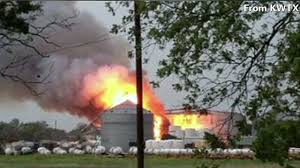
A massive explosion at a fertilizer plant in the small Texas town of West left at least two people dead, leveled several homes and prompted a wide scale evacuation in the community of 2,600 people.

"It was a like a nuclear bomb went off," Mayor Tommy Muska said. "Big old mushroom cloud. There are a lot of people that got hurt. There are a lot of people that will not be here tomorrow."

Fire officials fear that the number of casualties could rise as high as 60 to 70 dead, said Dr. George Smith, the emergency management system director of the city.

"That's a really rough number, I'm getting that figure from firefighters, we don't know yet," he said.
"We have two EMS personnel that are dead for sure, and there may be three firefighters that are dead."

Fireball in the sky
The blast took place at the West Fertilizer Plant, about 18 miles north of Waco, about 8:50 p.m. ET.
The explosion: What we know so far
It sent a massive fireball into the sky. Flames leaped over the roof of a structure and a plume of smoke rose high into the air.
"There are lots of houses that are leveled within a two-block radius," Smith said. "A lot of other homes are damaged as well outside that radius."
He estimated that between 10 to 15 buildings were demolished and about 50 damaged.
And the danger may not be over.
Risk remains
Residents are being evacuated because officials are worried that another tank at the facility might explode.
"What we are hearing is that there is one fertilizer tank that is still intact at the plant, and there are evacuations in place to make sure everyone gets away from the area safely in case of another explosion," said Ben Stratmann, a spokesman for Texas State Sen. Brian Birdwell.
Firefighters at the scene said they were concerned aboutanhydrous ammonia, a pungent gas with suffocating fumes that is used as a fertilizer.
When exposed to humans, it can cause severe burns if it combines with water in the body.
And exposure to high concentrations can lead to death.
The scene
State troopers in gas masks set up roadblocks, waving away cars coming off the highway.
The Federal Aviation Administration instituted a flight restriction over the town. Schools will be closed for the rest of the week, and officials urged everyone to stay away from school property.
Shortly after the explosion, more than 60 patients streamed intoHillcrest Hospital in Waco, suffering from "blast injuries, orthopedic injuries (and) a lot of lacerations," said hospital CEO Glenn Robinson.
While some of the injuries are minor, others are "quite serious," he said.
The West Fertilizer Plant is just north of Waco. A nursing home with 133 residents was near the plant.
Smith, the EMS director, said he didn't know whether there were casualties reported in the nursing home.
'It was intense'
Tommy Alford, who works in a convenience store about three miles from the plant, told CNN that several volunteer firefighters were at the store when they spotted smoke.
Alford said the firefighters headed toward the scene and then between five and 10 minutes later, he heard a massive explosion.
"It was massive; it was intense," Alford said.
Cheryl Marak, who sits on West's city council, said the impact of the blast knocked her to the ground.
"It demolished both the houses there, mine and my mom's and it killed my dog," she said.
Other residents had similar stories.

read more at http://www.cnn.com/


Live Updates: West Texas Fertilizer Plant Explosion Injures More Than 100

Apr 18, 2013 1:02am
1:43 a.m. ET: Mayor of West Tommy Muska said in a news conference said they are concerned about the wind – which they expect to change direction about 3 a.m.
Muska told residents to stay in inside because of the hydrous gas that is still in the air.
1:25 a.m. ET: The explosion registered as 2.1 magnitude quake according theUSGS. Residents about 30 miles away in the town of Buffford told ABC News that they felt the quake.
ap Plant ac 130418 wblog Live Updates: West Texas Fertilizer Plant Explosion Injures More Than 100
AP Photo/Waco Tribune Herald, Rod Aydelotte
1:21 a.m. ET: VIDEO: Homes and business were completely destroyed around the West, Texas, fertilizer plant.

1:09 a.m. ET:  Texas Department of Public Safety trooper D.L. Wilson said in a short news conference that there are more than 100 injuries with fatalities confirmed but did not specify how many deaths. Officials are searching for more people and are doing a house by house search.  About 133 people were evacuated from a nursing home.  About half the town has been evacuated.  Between 50-75 buildings were destroyed or damaged.
“Massive. Just like Iraq. Just like the Murray Building in Oklahoma City… So you can imagine what kind of damage we’re looking at,” Wilson said in describing the blast.
12:53 a.m. ET: Blood drives are planned for Thursday in Texas. Linda Goelzer of Carter Blood Care, the primary blood support service supporting more 58 counties, largest blood provider in Texas told ABC News the people in the community of West are “heart of gold people, like a Norman Rockwell painting.”
“The whole town is being evacuated. We had our blood supply pretty well stocked in Waco as of today but now we are sending more than 300 units of blood from Dallas Fort Worth down to Waco, that’s where patients are going. Many are being care-flighted to Parkland Hospital in Dallas for treatment at their burn center,” Goelzer said.
“Tonight our message to our donors is don’t everybody come at once, we will have patients for who knows how long who will be needing blood. Especially O-negative are needed, universal donor, will likely be expended tonight. What we tell people is that the blood helping people tonight is what’s already on the shelves. What we’ll need most is for consistency. We have blood drives everyday and we will have them tomorrow, we just don’t want people flooding in, in droves, like they did after 9/11. We’re asking our regular donors to keep coming throughout the week because we expect there will be many survivors.”
12:33 a.m. ET: At least 124 people hospitalized, with one hospital telling us that 20 more are on the way.  Of those, 38 considered serious.
 Live Updates: West Texas Fertilizer Plant Explosion Injures More Than 100
AP Photo/Michael Ainsworth/The Dallas Morning News
12:19 a.m. ET: According to the CEO of Baptist Hillcrest Medical Center, Brett Esrock (in Waco) officials are triaging the wounded. Baptist has treated, or is treating 29 wounded, mostly minor to moderate injuries: cuts abrasions, broken bones, respiratory distress, and one critical injury. Hospital officials are being told they are about to receive an additional 20 patients “they are coming in ambulances cars vans, pretty much anything.” Other wounded people are also being sent to Hillsboro Regional Hospital, which has apparently received another 60 patients.  -  Matt Gutman
11:48 p.m. ET: West City Hall suffered significant damage according to Gail Scarborough with Texas Department of Public Safety. The middle school also caught on fire due to a gas leak in the building.
11:00 p.m. ET: Texas Gov. Rick Perry released the following statement on the explosion in West, Texas:  “We are monitoring developments and gathering information as details continue to emerge about this incident. We have also mobilized state resources to help local authorities. Our thoughts and prayers are with the people of West, and the first responders on the scene.”
abc wfaa texas explosion 130417 wblog Live Updates: West Texas Fertilizer Plant Explosion Injures More Than 100
ABC
9:33 p.m. ET: According to a dispatcher at Texas Department of Public Safety, there were two explosions and a fire reported at a Fertilizer Plant in the town of West, Texas.

Monday, June 13, 2011

UPDATE: 6-13-2011 HAARP CAUSED: SEVERE WEATHER WARNING Center of Columbus, MS. Please read!!

UPDATE: 6-13-2011
CURRENTLY ROTATING SEVERE THUNDERSTORMS, HAIL, HEAVY RAIN, AND SOME FUNNEL CLOUD SITINGS IN THE AREAS TO THE WEST, NORTH AND SOUTH OF COLUMBUS, MS. ...HEADING TOWARDS THE EAST.  


HAARP CAUSED: SEVERE WEATHER WARNING


Severe weather will occur within 24-48 hours in a radius of approximately 200 miles with the center near Columbus, MS.  The outer portion of the severe weather from this HAARP ring will be along the lines of Jackson, TN, Huntsville, AL, Montgomery AL, Jackson, MS., and you get my point.  There is a high chance of damaging winds and hail, severe thunderstorms, tornadic activity, and flooding.  Please prepare.


http://radar.weather.gov/Conus/southmissvly.php

UPDATE: 6-13-2011 HAARP:Severe Weather Alert for Florida and Surrounding Area.

UPDATE: 6-13-2011
SEVERE THUNDERSTORMS, HAIL, ROTATING THUNDERSTORMS, AND HEAVY RAIN ARE CURRENTLY OCCURRING IN THE SURROUNDING AREA OF JACKSONVILLE, FLORIDA.  


HAARP:Severe Weather Alert...

Within a 230 mile radius of Jacksonville, Florida, expect severe weather within 24-48 hours. This may include damaging hail, high winds, severe thunderstorms, and possible tornadic activity.  This includes areas of Georgia and possibly South Carolina as well.


Thank you to our source for this graphic...The National Weather Service http://radar.weather.gov/Conus/southeast.php

Tuesday, April 26, 2011

It May Be Easier To Count The States Without Tornadoes, Tornado Warnings, and Tornado Watches.

Today has been a busy weather day!  I'm sure that all of the HAARP "experiments" have helped our global weather to change like crazy...but I'm only going to refer to what I see going on in the United States right now.

This is going to be in the form of kind of a list, but you'll soon see that it may be easier to count the states that don't have tornadoes, tornado warnings and tornado watches, as well as other unseasonable weather today.


Alabama

***************************************************************************************

Arkansas

This is the actual tornado that hit Vilonia,AR. #vilonia #arwx Pic by Jesse Herdon, a friend in Vilonia.
picture credits go to Jesse Herdon, http://twitpic.com/4pmcz5

Tornado Warning
Tornado Watch
Severe Thunderstorm Warning
Flash Flood Warning, Areal Flood Warning
Flash Flood Warning
Flash Flood Warning, Areal Flood Warning
Flood Warning, Areal Flood Warning
Flash Flood Warning
Flood Warning
Areal Flood Warning
Flash Flood Watch
Flash Flood Watch, Flood Advisory
Wind Advisory

Eight killed by tornadoes and flooding in central U.S.

The storm killed four people, told AFP spokeswoman Arkansas Department of Emergency Renee Presslar.Equipos search and rescue workers were assessing the damage in this region, which is forecast to be affected by new storms along Tuesday.

Indiana


Tornado Watch Area

APRIL 26, 2011
t-watch-number-2
source: http://www.paulpoteet.com/blog/2011/04/26/tuesday-tornado-watch-number-2/

******************************************************************
Michigan
The National Weather Service has issued a tornado watch for all of southeast Michigan, including Washtenaw County, until 10 tonight.
Tornadoes, hail to 2 inches in diameter, wind gusts to 70 mph and dangerous lightning are possible, the Weather Service said.
A tornado watch means conditions are favorable for tornadoes and thunderstorms.
***********************************************************************
Texas


width:200 and height: 120 and picwidth: 200 and pciheight: 120
Font Size:   
6:00pm
Most of the severe weather is moving out of the northeastern portions of the area. One very severe storm with hail up to quarter size, frequent lightning and winds between 40 to 60mph. The thunderstorm warning has been moved to a "Significant Weather Advisory" in effect until 6:30pm as this storm blows past Grapeland and into far Eastern Houston County.

More hail pictures coming in from Robertson County as the storm passed through around 4:45pm. These ping pong sized hail pictures we sent in by Pete and Carolyn Christian:


5:44pm
Pictures sent in from James and Michael Smith as a severe storm passed through Hearne earlier this evening:


5:35pm
Significant Weather Advisory for Madison County until 6pm. Winds in excess of 40mph and hail up to 1/2" in diameter could be possible as this storm skirts the Leon / Madison County line.
5:30pm
Severe Thunderstorm Warning is still the official word in Houston County, however, Pinpoint Radar is showing an area that could be trying to rotate within this storm near Grapeland along Hwy 287.
5:36pm
Severe Thunderstorm Warning supposed to run until 5:45pm for Robertson County. That storm is currently moved into Southern Leon County and is weakening a bit. Therefore, Robertson County, you are in the clear for now.
5:20pm
Tornado Warning has been dropped from Leon County and replaced with a Severe Thunderstorm Warning until 6:15pm. Golfball size hail and winds in excess of 60mph will still be possible as this storm moves past Flo and Rural parts of Leon County into Houston County.
A Severe Storm continues to push out of Southeast Robertson County and is beginning to weaken a bit as it moves into Southern Leon County. Large hail and strong, damaging winds are moving towards Hilltop Lakes and Normangee and then eventually onto Leona.
5:05pm
TORNADO WARNING has been issued for Eastern Leon County until 5:45pm. This storm is located to to the East of Flo moving to the Northeast at 30mph. Storm will be moving into northwest Houston County shortly.
source: http://www.kbtx.com/home/headlines/Tornado_Watch_in_Effect_for_the_Northern_Brazos_Valley_120735724.html

... A TORNADO WARNING REMAINS IN EFFECT UNTIL 600 PM CDT FOR NORTHEASTERN ELLIS AND SOUTHERN KAUFMAN COUNTIES...
AT 519 PM CDT... STORM SPOTTERS AND DOPPLER RADAR OBSERVED A DEVELOPING TORNADO. THIS TORNADO WAS LOCATED NEAR PALMER... MOVING EAST AT 30 MPH.
THE TORNADO WILL BE NEAR... ROSSER AROUND 535 PM CDT... COTTONWOOD AROUND 540 PM CDT... GRAYS PRAIRIE AROUND 550 PM CDT... OAK GROVE AND KAUFMAN AROUND 555 PM CDT... KEMP AROUND 600 PM CDT...
THIS WILL IMPACT I-45 BETWEEN MILE MARKERS 251 AND 263.
*************************************************************************************
Kentucky
... A TORNADO WARNING REMAINS IN EFFECT UNTIL 545 PM CDT FOR EAST CENTRAL HOPKINS... SOUTHEASTERN MCLEAN AND SOUTH CENTRAL DAVIESS COUNTIES IN NORTHWEST KENTUCKY... AND NORTHERN MUHLENBERG COUNTY IN SOUTH CENTRAL KENTUCKY...
AT ABOUT 509 PM CDT... A TORNADO WAS REPORTED IN HANSON BY MEDIA. AN INJURY WAS REPORTED WITH THIS TORNADO. AT 520 PM CDT... THIS STORM WAS LOCATED 3 MILES SOUTHWEST OF SACRAMENTO... MOVING EAST AT 45 MPH.
LOCATIONS IN THE WARNING INCLUDE BREMEN... SOUTH CARROLLTON... ISLAND AND LIVERMORE.
******************************************************************************
Missouri
Erica Cross stands on a friends porch surrounded by floodwater Tuesday, April 26, 2011, in Poplar Bluff, Mo.
Erica Cross stands on a friend's porch surrounded by floodwater Tuesday, April 26, 2011, in Poplar Bluff, Mo. (AP Photo / Jeff Roberson)
Floodwaters threatened earthen levees protecting thousands of homes in the nation's midsection Tuesday, rising so fast in some places that panicked residents didn't have time to pile up sandbags....

Storms have unleashed as much as 15 inches of rain across the region, and the forecast offered little hope for relief. Another, larger storm system was brewing along the same path, bringing several more days of rain and the threat of tornadoes.


******************************************************************************************

Illinois, Ohio, Michigan, Indiana
Tornado Watch 216
< Previous WW         Next WW >
||||||
WW0216 Probability
HazardTornadoesEF2+ Tornadoes
LikelihoodModerateLow
Severe Wind65 kt+ Wind
ModerateModerate
Severe Hail2"+ Hail
ModerateModerate

Note:  Click for Complete Product Text. 
Tornadoes
Probability of 2 or more tornadoes 
Mod (40%)
Probability of 1 or more strong (F2-F5) tornadoes
Low (20%)
Wind
Probability of 10 or more severe wind events
Mod (30%)
Probability of 1 or more wind events > 65 knots
Mod (30%)
Hail
Probability of 10 or more severe hail events
Mod (40%)
Probability of 1 or more hailstones > 2 inches
Mod (30%)
Combined Severe Hail/Wind
Probability of 6 or more combined severe hail/wind events
High (80%)
For each watch, probabilities for particular events inside the watch (listed above in each table) are determined by the issuing forecaster. The "Low" category contains probability values ranging from less than 2% to 20% (F2-F5 tornadoes), less than 5% to 20% (all other probabilities), "Moderate" from 30% to 60%, and "High" from 70% to greater than 95%. High values are bolded and lighter in color to provide awareness of an increased threat for a particular event.
Top of Page/Status Messages for this watch/All Current Watches/Forecast Products/Home


***********************************************************************************
Oklahoma, Arkansas

Tornado Watch 221
< Previous WW
|||||
WW0221 Probability
HazardTornadoesEF2+ Tornadoes
LikelihoodModerateModerate
Severe Wind65 kt+ Wind
ModerateModerate
Severe Hail2"+ Hail
HighModerate

Note:  Click for Complete Product Text. 
Tornadoes
Probability of 2 or more tornadoes 
Mod (60%)
Probability of 1 or more strong (F2-F5) tornadoes
Mod (30%)
Wind
Probability of 10 or more severe wind events
Mod (50%)
Probability of 1 or more wind events > 65 knots
Mod (30%)
Hail
Probability of 10 or more severe hail events
High (70%)
Probability of 1 or more hailstones > 2 inches
Mod (30%)
Combined Severe Hail/Wind
Probability of 6 or more combined severe hail/wind events
High (90%)
For each watch, probabilities for particular events inside the watch (listed above in each table) are determined by the issuing forecaster. The "Low" category contains probability values ranging from less than 2% to 20% (F2-F5 tornadoes), less than 5% to 20% (all other probabilities), "Moderate" from 30% to 60%, and "High" from 70% to greater than 95%. High values are bolded and lighter in color to provide awareness of an increased threat for a particular event.
Top of Page/Status Messages for this watch/All Current Watches/Forecast Products/Home


URGENT - IMMEDIATE BROADCAST REQUESTED
   TORNADO WATCH NUMBER 221
   NWS STORM PREDICTION CENTER NORMAN OK
   510 PM CDT TUE APR 26 2011
   
   THE NWS STORM PREDICTION CENTER HAS ISSUED A
   TORNADO WATCH FOR PORTIONS OF 
   
          PARTS OF NORTHERN ARKANSAS
          PARTS OF EASTERN OKLAHOMA
   
   EFFECTIVE THIS TUESDAY AFTERNOON AND EVENING FROM 510 PM UNTIL
   1000 PM CDT.
   
   TORNADOES...HAIL TO 3 INCHES IN DIAMETER...THUNDERSTORM WIND
   GUSTS TO 70 MPH...AND DANGEROUS LIGHTNING ARE POSSIBLE IN THESE
   AREAS.
   
   THE TORNADO WATCH AREA IS APPROXIMATELY ALONG AND 55 STATUTE
   MILES NORTH AND SOUTH OF A LINE FROM 25 MILES SOUTHWEST OF
   MCALESTER OKLAHOMA TO 10 MILES EAST NORTHEAST OF BATESVILLE
   ARKANSAS.  FOR A COMPLETE DEPICTION OF THE WATCH SEE THE
   ASSOCIATED WATCH OUTLINE UPDATE (WOUS64 KWNS WOU1).
   
   REMEMBER...A TORNADO WATCH MEANS CONDITIONS ARE FAVORABLE FOR
   TORNADOES AND SEVERE THUNDERSTORMS IN AND CLOSE TO THE WATCH
   AREA. PERSONS IN THESE AREAS SHOULD BE ON THE LOOKOUT FOR
   THREATENING WEATHER CONDITIONS AND LISTEN FOR LATER STATEMENTS
   AND POSSIBLE WARNINGS.
   
   OTHER WATCH INFORMATION...CONTINUE...WW 213...WW 214...WW
   215...WW 216...WW 217...WW 218...WW 219...WW 220...
   
   DISCUSSION...SEVERE THUNDERSTORMS INCLUDING SUPERCELLS ARE
   DEVELOPING VICINITY WARM FRONTAL ZONE ACROSS THE WATCH. WITH SHEAR
   CONTINUING TO INCREASE SUPERCELLS WILL INCLUDE BOTH LARGE HAIL AND
   TORNADO THREAT.
   
   AVIATION...TORNADOES AND A FEW SEVERE THUNDERSTORMS WITH HAIL
   SURFACE AND ALOFT TO 3 INCHES. EXTREME TURBULENCE AND SURFACE
   WIND GUSTS TO 60 KNOTS. A FEW CUMULONIMBI WITH MAXIMUM TOPS TO
   500. MEAN STORM MOTION VECTOR 24035.


Source: http://www.spc.noaa.gov/products/watch/ww0221.html?utm_source=twitterfeed&utm_medium=twitter
*********************************************************************
Mississippi

More Severe Weather Expected for Mississippi Valley Today

Another day of severe thunderstorms and tornadoes is forecast for northeastern Texas and throughout Arkansas, where Governor Mike Beebe declared a state of emergency after a series of violent storms.
At least seven people were killed by storms in Arkansas overnight, according to the Associated Press. The area will probably get raked again later today, according to the U.S. Storm Prediction Center in Norman, Oklahoma.
“Dangerous tornado and severe thunderstorm outbreak expected late this afternoon into tonight,” the storm center said in a bulletin. “Very large hail and damaging winds will also be likely.”
In the past three years, thunderstorms have caused a record $30 billion worth of insured damage, according to the Insurance Information Institute in New York. Last year, thunderstorms and tornadoes in the U.S. caused about $13.1 billion in damage, according to the institute.
...In addition to the thunderstorms and tornadoes, flood warnings and advisories cover most of eight states along the Ohio and Mississippi rivers, according to the weather service.
About 1,000 people living along the Black River near Poplar Bluff, Missouri, were evacuated because of a damaged levee, which threatens 500 structures in the town, according to the weather service. Poplar Bluff is 155 miles south of St. Louis.
Louisiana
STATUS REPORT #1 ON WW 220

VALID 262240Z - 262340Z

THE SEVERE WEATHER THREAT CONTINUES ACROSS THE ENTIRE WATCH AREA.

..EDWARDS..04/26/11

ATTN...WFO...LCH...SHV...HGX...EWX...

&&

STATUS REPORT FOR WT 220 

SEVERE WEATHER THREAT CONTINUES FOR THE FOLLOWING AREAS 

LAC011-013-021-031-043-049-059-061-069-073-079-081-085-115-127-
262340-

LA 
.    LOUISIANA PARISHES INCLUDED ARE

BEAUREGARD	     BIENVILLE		 CALDWELL	     
DE SOTO 	     GRANT		 JACKSON	     
LA SALLE	     LINCOLN		 NATCHITOCHES	     
OUACHITA	     RAPIDES		 RED RIVER	     
SABINE		     VERNON		 WINN		     
$$

****************************************************
Tennessee
Now - Click for more information.

source: http://www.srh.noaa.gov/bna/

*************************************************************
New York and Pennsylvania

Click to view the Hazardous Weather OutlookCentral NY and Northeast PA
Click on the map below for the latest forecast.
Last map update: Tue, Apr. 26, 2011 at 7:23:52 pm EDT
Read watches, warnings & advisories
National Weather Service Buffalo, NYNational Weather Service Burlington, VT

Zoom
Out

National Weather Service Albany, NY
National Weather Service State College, PANational Weather Service Philadelphia, PANational Weather Service New York City/Upton,NY
Severe Thunderstorm Warning
Flash Flood Warning
Severe Thunderstorm Watch
Flash Flood Watch
Severe Weather Statement
Flood Warning
Flood Advisory
Dense Fog Advisory
Flood Watch
Special Weather Statement
Marine Weather Statement
Hazardous Weather Outlook
Weather Discussion: A warm front will move slowly northward through the region tonight, with additional showers and thunderstorms expected. Hit and miss showers and thunderstorms will dot the area on Wednesday, before more widespread rainfall comes back in late Wednesday night and Thursday, along an incoming cold front.
See Full Discussion
source: http://www.erh.noaa.gov/er/bgm/

**************************************************************
West Virginia, North Carolina


Looking For An Update? Forecasts Below Refreshed Every 3 Hours
RoanokeLynchburgLewisburg, WVBlacksburgBoone, NCOthers...


Quick Glimpse at the Weather and Local Hazards


Blacksburg, VA
Click on the map below for the latest forecast.
Last map update: Tue, Apr. 26, 2011 at 7:32:33 pm EDT
Read watches, warnings & advisories
National Weather Service Jackson, KYNational Weather Service Charleston, WVNational Weather Service Baltimore/Washington, DC
National Weather Service Morristown, TN
Zoom
Out

National Weather Service Wakefield, VA
National Weather Service Greenville-Spartanburg, SCNational Weather Service Raleigh, NCNational Weather Service Newport/Morehead City, NC
Tornado Warning
Severe Thunderstorm Warning
Severe Thunderstorm Watch
Flash Flood Watch
Severe Weather Statement
Flood Advisory
Wind Advisory
Special Weather Statement
Hazardous Weather Outlook
Short Term Forecast
Choose from the options below for other ways to view your NWS forecast

Source: http://www.erh.noaa.gov/er/rnk