Ad

Showing posts with label emergency plan. Show all posts

Wednesday, November 23, 2011

Earthquake Warning! Earthquake Warning! Prepare For Another Big One


This is an interactive map for Yellowstone below.  There are other interactive maps as well if you would like to explore the site below.

Map of Yellowstone Webicorder stations
About the Webicorder Display, including interpreted examples of earthquake recordings.
Webicorder displays are organized by region. They can be accessed using links from regional station maps or stations lists.
  • Station maps for the Utah Region, Yellowstone Region, and Teton Region provide an easy interactive path to available Webicorders for the last seven days.

    (Note: The Teton region stations are maintained and operated by the U.S. Geological Survey. The Webicorder displays are provided as a service to the Advanced National Seismic System.) 
http://www.quake.utah.edu/helicorder/yell_webi.htm

Are You Ready? Guide

"Are You Ready?"  Guide book cover.An In-depth Guide to Citizen Preparedness

Are You Ready? An In-depth Guide to Citizen Preparedness (IS-22) is FEMA’s most comprehensive source on individual, family and community preparedness. The guide has been revised, updated and enhanced in August 2004 to provide the public with the most current and up-to-date disaster preparedness information available.

Are You Ready? provides a step-by-step approach to disaster preparedness by walking the reader through how to get informed about local emergency plans, how to identify hazards that affect their local area and how to develop and maintain an emergency communications plan and disaster supplies kit. Other topics covered include evacuation, emergency public shelters, animals in disaster and information specific to people with access and functional needs.

Are You Ready? also provides in-depth information on specific hazards including what to do before, during and after each hazard type. The following hazards are covered: Floods, Tornadoes, Hurricanes, Thunderstorms and Lightning, Winter Storms and Extreme Cold, Extreme Heat, Earthquakes, Volcanoes, Landslide and Debris Flows (Mudslide), Tsunamis, Fires, Wildfires, Hazardous Materials Incidents, Household Chemical Emergencies, Nuclear Power Plant and Terrorism (including Explosion, Biological, Chemical, Nuclear and Radiological hazards).

Are You Ready? is also available in Spanish, and can be used in a variety of ways including as a read-through or reference guide. The guide can also be used as a study manual guide with credit awarded for successful completion and a 75 percent score on a final exam. Questions about the exam should be directed to the FEMA Independent Study Program by calling 1-800-238-3358 or by going to training.fema.gov/is.

Also available is the Are You Ready? Facilitator Guide (IS-22FG). The Facilitator Guide is a tool for those interested in delivering Are You Ready? content in a small group or classroom setting. The Facilitator Guide is an easy to use manual that has instruction modules for adults, older children and younger children. A resource CD is packaged with the Facilitator Guide that contains customizable presentation materials, sample training plans and other disaster preparedness education resources.
Copies of Are You Ready? and the Facilitator Guide are available through the FEMA publications warehouse (1.800.480.2520). For large quantities, your organization may reprint the publication. Please visit our reprint page for more information.
For more publications on disaster preparedness, visit the Community and Family Preparedness webpage.

Are You Ready? An In-depth Guide to Citizen Preparedness Full Document (PDF - 21Mb)

http://www.ready.gov/are-you-ready-guide

    Wednesday, November 2, 2011

    A Day In Earthquakes. Are YOU Immune?


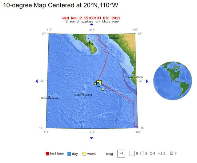
    http://earthquake.usgs.gov/earthquakes/recenteqsww/Maps/10/250_20.phphttp://earthquake.usgs.gov/earthquakes/recenteqsww/Maps/10/250_20.php

    Yesterday, there was a 6.3 located at the ....
    REVILLA GIGEDO ISLANDS REGION
    which is ....
    227 km (141 miles) NE of Socorro Island, Mexico
    333 km (206 miles) SSE of Cabo San Lucas, Baja Calif. Sur, Mexico
    419 km (260 miles) W of Puerto Vallarta, Jalisco, Mexico
    1050 km (652 miles) W of MEXICO CITY, D.F., Mexico

    Aftershocks in the 5.0-3.0 range have been recorded since.

    Turkey has been having aftershocks that are not much smaller than their original 5.2 quake, in the range of 4.6-4.7 magnitude.

    Yesterday's quake in China of 5.5, located in the region of SICHUAN-GANSU BORDER REGION, CHINA has been followed by a 5.1 earthquake not so far away, in the region of GANSU, CHINA. I see that there are no more quakes recorded in the region of NORTHERN XINJIANG, CHINA since the most recent 5.4.

    Japan continues to be an active region.

    Indonesia continues to be active with a 5.3 today in the region of KEPULAUAN BABAR, INDONESIA and a 5.0 in the region of SULAWESI, INDONESIA.

    Within the past hour there have been earthquakes in the following areas...
    5.5 PACIFIC-ANTARCTIC RIDGE
    2.6 NEVADA
    2.8 CENTRAL CALIFORNIA

    This is the representation of all of the earthquakes with 2.5 and higher magnitude in the past week, according to the USGS site.


    As always, no matter where you live, emergency preparedness is key when dealing with any natural disaster, including earthquakes, for which none of us are immune.