Ad

Showing posts with label Sink Holes. Show all posts

Sunday, August 18, 2013

Entire Crops Destroyed, Sink Holes, Flooding, Birds Falling to the Ground...Signs of the Times.

Short, powerful hail storm destroys entire crops in northern Colorado

WELD COUNTY, Colo. — Near Greeley, the farm fields are still muddy from the big hail storm and possible funnel clouds that spewed rain and destruction on the eastern plains.
The Platte River Valley is like the food-basket of the Front Range, but the weekend storm left crops looking battered, broken and destroyed.
“The hail only lasted about 12 minutes,” said Dave Petrocco owner of Petrocco Farms. “The storm began about 5:00 p.m. and cut a path about two miles wide across the land we farm here. As far as you can see we lost everything from onions, to pumpkins, to squash of all types. Our peppers were all set for harvest as were our beans, beets, lettuce and cabbage. Now, in a heartbeat it is all wiped out.”
Petrocco says losses such as this are not covered by insurance and he doesn’t quite know how to process a whole growing season lost. Farmers know they always run the risk of a loss when success depends on Mother Earth.
“We plant seeds in green houses, take seedlings into the field, plant them and care for them all summer. We have a huge investment in having a bountiful crop and when something like this happens it is devastating. At first you try to just accept the act of nature, but when all is said and done, the loss is tremendous. We all just hope to have enough put away to take a year’s loss, so we can come back next spring and do it all again,” said Petrocco.
The area hit is just north and east of Gilchrest, and south of Greeley. It’s just west of Highway 85.
The river bottom land is fertile and always yields a fine harvest—which was set to begin in days—but this year’s crop is pretty much a total loss for Petrocco Farms and others nearby.
James Werning farms just down the road a piece. He is growing seed corn and most of his rows of corn look as if someone thrashed them.
“In a few days we will know if the corn cobs will get pollinated… that is when the silk turns brown. If they do, we can salvage some, but if not we’ll cut and plow stalks under and wait for next year,” said Werning.
A farmer’s lot in life, the constant battle with nature. If it isn’t drought, it’s flooding or insects, and every so often hail on the plains.
But for those who plow, they know the risks and still they plant. But when it comes to next year, it is still about having funds to make things happen.

Don't Flip Out, but the Sun's Magnetic Field Is About to Flip

Our star is on the cusp of a once-in-11-years event, when its magnetic field undergoes a complete reversal. What does that mean for us?


The sun is about to undergo what sounds like a massive upheaval. In the next few months, scientists say, our star will experience a complete reversal of its magnetic field. The sun's north magnetic pole will become its south pole, and vice versa, in an event that will reverberate throughout the entire solar system. 

Although this kind of solar about-face can't help but have a certain apocalyptic, cats-and-dogs-living-together aspect to it, the phenomenon is perfectly normal—and benign. There will likely be small influences on weather patterns and, interestingly, temporarily less lightning in thunderstorms. Meanwhile, astronauts working on the International Space Station will be afforded a little extra protection against cosmic radiation. "This happens every 11 years," solar physicist Todd Hoeksema says. "We've survived all the last ones." 

In Flux 

The imminent field inversion is a natural part of the sun's approximately 11-year solar cycle of magnetic activity. The sun is currently going through what is known as solar maximum, when extra magnetic activity translates into greater chances of space weather-spawning events such as flares and coronal mass ejections, which can bombard the Earth with radiation and solar material. These events can trigger auroras—a nice bonus—but also disrupt satellite operations and even damage power grids on the ground (though the sun's current cycle has been the weakest in a century). 

The polarity reversal, expected in the next three to four months, will mark the midpoint of solar maximum. Over the following five and a half years, the sun's average magnetic storminess will die down to a solar minimum, after which things will ramp right back up again. 

Hoeksema and his colleagues monitor the magnetic activity at the sun's poles from Stanford University's Wilcox Solar Observatory. Hoeksema, who is the observatory's director, said that the sun's polar magnetic fields have been weakening, will zero out, and then return with opposite polarities. The north pole has apparently already switched over, essentially giving the sun two south poles for the moment. But the south pole will soon catch up, and the polarity reversal will complete itself. 

The magnetic flip comes about as a result of strong, local magnetic fields associated with sunspots bursting out around the sun's equator and then migrating poleward. This so-called magnetic flux "eats away at the existing polar field and gradually over a period of a couple years erodes all of it," Hoeksema says. "Then more flux comes up and turns the polar field into the other direction." 

Protective Bubble 

The sun's magnetic field influences a vast, bubble-like region of space dubbed the heliosphere, which extends for billions of miles, beyond even far-out Pluto. With a polarity switcheroo in the offing, the heliosphere has been seeing some changes recently. 

The heliosphere is electrically molded by the current sheet, a vast plane of weak current created by the sun's slowly rotating magnetic fields. The current sheet extends out from the sun's equator across the solar system, like a skirt from the waist of a twirling dancer. The current sheet "acts like a big deflector shield," Hoeksema says, helping to protect Earth and the other planets from high-energy intruders known as galactic cosmic rays—particles that are shot out of supernovas and other violent celestial phenomena. 

Within Earth's magnetic field, all but the highest-energy galactic cosmic rays are kicked aside. But for astronauts and satellites in orbit, cosmic rays can be bad news. Like atomic bullets, cosmic rays damagingly pierce matter, including our bodies' cells as well as machine components. 

During solar maximum, the current sheet's shape becomes rumpled compared to near solar minimum. "At this point in the cycle when polarity is reversing, the current sheet extends all the way to the [sun's] poles," Hoeksema says. "What that does is affect how cosmic rays from the galaxy enter the heliosphere and make their way to Earth." The effect is beneficial: An expanded, wavy current sheet keeps more cosmic rays at bay and protects astronauts. "The sun is shielding the whole heliosphere, so we see fewer cosmic rays now than at solar minimum." 

Weird Weather 

Besides being good news for astronauts, fewer cosmic rays in the neighborhood could also have an impact on our weather. Cosmic rays ionize Earth's upper atmosphere, which affects the formation of clouds, storms, and lightning. Terrestrial storms might be a bit less intense, therefore, around solar maximum, Hoeksema says, but the overall connection remains speculative. 

Intriguing examples of correlations among the state of the current sheet, cosmic-ray peppering, and climate do exist. "Locally around the world you see places where the weather changes with a 22-year cycle related to these cosmic rays," Hoeksema says. He pointed to drought records in the southwestern United States and tree-ring records from a variety of places, such as the Pacific coast. 

Overall, the polarity reversal is "changing things on the scale of the whole solar system," Hoeksema says. But don't expect anything cataclysmic here on Earth. 


Read more: Don't Flip Out, but the Sun's Magnetic Field Is About to Flip - Popular Mechanics
Follow us: @PopMech on Twitter | popularmechanics on Facebook
Visit us at PopularMechanics.com
THE FOLLOWING VIDEO
Published on Aug 11, 2013
The first 10 days of August has been both strange and extreme with some dramatic and intense moments. With so much going on I'll be posting around every 10 days now. The work is getting hard to do each week without missing much. Also Check out the new channel Last Message (By 2011Message) for his series 2013 Is Strange.

Thursday, January 24, 2013

The New Madrid Fault. Booms. Earthquake. Methane Gas Releasing. Sinkhole.

THE FOLLOWING WILL BE IMPORTANT REGARDING THE NEW MADRID FAULT...
The following video...


Published on Jan 15, 2013
Plug in all the data and see for yourself, here's the links:

BOOMS:

Guthrie, Oklahoma: http://kfor.com/2013/01/04/mysterious-boom-heard-in-guthrie/
Cater County, Oklahoma:http://www.kten.com/story/20271784/loud-booms-heard-across-texoma-has-confirm...
QUAKES:
Spencer, Oklahoma:http://earthquake.usgs.gov/earthquakes/eventpage/usc000eli9#summary
Healdton, Oklahoma:http://earthquake.usgs.gov/earthquakes/eventpage/usc000ei5q#summary

BOOMS:

Evensville, Indiana http://www.14news.com/story/20537321/did-you-hear-the-booms
http://tristatehomepage.com/fulltext-news?nxd_id=575392
QUAKE:
Marion, Illinoishttp://earthquake.usgs.gov/earthquakes/eventpage/nm011113a#summary

BIRDS FALLING DEAD:

Seymour, Tennesee http://www.newschannel9.com/news/top-stories/stories/dead-birds-fall-sky-3646...
QUAKE:
Madisonville, Tennesseehttp://earthquake.usgs.gov/earthquakes/eventpage/se010813a#summary

BOOMS:

Lexington County, South Carolinahttp://www.wistv.com/story/20525068/searching-for-the-cause-of-booms-reported...
Columbia County, Georgiahttp://www2.wjbf.com/news/2012/dec/06/3/several-loud-booms-reported-columbia-...

Explosion Sounds:

Trumbull County, Ohiohttp://www.wkbn.com/content/news/local/story/Explosion-Sounds-Reported-in-Tru...

BOOMS:

Jamestown, New York http://www.wivb.com/dpp/news/local/loud-boom-jolts-southern-tier

BOOMS:

Salem, Massachusetts http://salem.patch.com/articles/did-you-hear-a-loud-bang-eary-saturday-morning
Barrington, Rhode Islandhttp://www.wpri.com/dpp/news/local_news/east_bay/explosion-heard-on-bay-nothi...

QUAKE:

Hawkesbury, Canadahttp://earthquake.usgs.gov/earthquakes/eventpage/ld60023403#summary
Boothbay Harbor, Mainehttp://earthquake.usgs.gov/earthquakes/eventpage/usb000enwr#summary

Canada Seismic Hazard map:

http://atlas.nrcan.gc.ca/site/english/maps/environment/naturalhazards/earthqu...

USGS Earthern US Seismic Hazard Map:

http://www.usgs.gov/blogs/features/files/2012/08/Screen-Shot-2012-08-28-at-1....

BOOM/QUAKE Map of everything pinned:

https://maps.google.com/maps/ms?msid=200270150651160417375.0004d3458c51989c71...


Areas prone to collapse sinkholes

The map below shows areas of the United States where certain rock types that are susceptible to dissolution in water occur. In these areas the formation of underground cavities can form and catastrophic sinkholes can happen. These rock types are evaporites (salt, gypsum, and anhydrite) and carbonates (limestone and dolomite). Evaporite rocks underlie about 35 to 40 percent of the United States, though in many areas they are buried at great depths.
Map of the United States showing areas where rock that are prone to dissolution and sinkholes are prevalent.

source: USGS

Monster Sinkholes An Indication That Major Earth Changes Are Coming Along The New Madrid Fault?

The most powerful earthquakes in the history of the United States happened along the New Madrid Fault in 1811 and 1812.  Those earthquakes were reportedly felt more than 1,000 miles away.  Scientists assure us that one day we will once again see very powerful earthquakes along the New Madrid fault.  It is only a question of when it will happen. Today, the New Madrid fault zone covers portions of Illinois, Indiana, Missouri, Arkansas, Kentucky, Tennessee and Mississippi.  However, a major earthquake of magnitude-8.0 or greater would likely have a dramatic effect all the way from the Great Lakes all the way down to the Gulf of Mexico.  When most Americans speak of the “big one”, they think of what may happen along the coast of California someday, but the truth is that a New Madrid earthquake could potentially do far more damage.  So is there evidence that the New Madrid fault zone is waking up?  Yes, there is.  According to Bloomberg, there has been “a sixfold increase in the number of earthquakes that have shaken the central part of the U.S. from 2000 to 2011″.  Much of that increase is being blamed on human activity such as mining, drilling and fracking.  So could human activity aggravate the fault zone so much that it could set off a truly history-making earthquake at some point?  Well, the potential is certainly there.  That is why so many people are so concerned about the monster sinkholes that have appeared in the region in recent months.  For example, a massive sinkhole down in Louisiana is now over 8 acres in size and it has forced hundreds of people to flee from their homes.  You can see video of the Louisiana sinkhole right here.  Over in Ohio, a giant sinkhole has suddenly formed that is more than 30 feet deep and that is the size of four football fields.  That sinkhole caused part of State Route 516 to collapse and authorities say that it will likely be closed for many months.  You can see video of the gigantic sinkhole in Ohio right here.  Are these monster sinkholes an indication that major earth changes are coming along the New Madrid fault?  Has reckless human activity awoken a sleeping giant that we should never have messed with?
The sinkhole down in Louisiana is of particular concern because it has been venting natural gas.  A few days ago it reportedly “burped” which sounds kind of ominous.  Could we see some kind of an “explosion” at some point?
Many of those living in the area may not be able to return to their homes for quite a long time.  The following is from a recent Huffington Post article…
At the eight-acre, Bayou Corne sinkhole in Assumption Parish, owners of slab houses are waiting for methane-gas monitors to be installed in December. The sinkhole deepened in November and coughed up debris and hydrcarbons late in the month. Cypress trees fell into the gap. Residents are watching natural gas being flared from the site and are ventilating homes while bayous around them bubble.
But if human activity is capable of producing sinkholes that are 8 acres in size and capable of causing a “sixfold increase” in the number of earthquakes in the middle part of the country, is human activity also capable of setting off the New Madrid fault?
Sadly, even most Americans that are living in that part of the country don’t really understand how incredibly massive and how potentially destructive this fault zone actually is.  The following is from a recent report from WREG in Memphis, Tennessee
Many people don’t realize that north Alabama lies in the impact zone of the New Madrid fault line, a sleeping giant that is approximately twenty times larger than California’s famed San Andreas fault. 
The biggest earthquake in U.S. history happened in the New Madrid seismic zone in 1812, and in just the last few weeks, activity along the fault line is starting to heat up. 
If the earthquakes that happened along the New Madrid fault zone in 1811 and 1812 happened today, the devastation would be unimaginable.  Back then, there were not that many people living in the area.  But even so, the destruction was incredible…
Accounts of the 1812 quake vary since there were no measuring instruments at the time, but most geologists say evidence shows it was at least a magnitude 8 earthquake, and possibly a 9 or higher.
The shaking was so intense that church bells started ringing as far away as Boston and New York.
Chimneys toppled from the Deep South to Canada, and President James Madison was awoken by the violent shaking as he slept in the White House.
Eyewitnesses said it even caused the Mississippi River to flow backwards for a time.
Unfortunately, there are now indications that the fault zone is becoming more active as a recent Examiner article explained…
Tuesday evening, two shallow earthquakes, although small, were felt in Mt. Carmel, Ill. as well as five miles outside Edmond, Okla. Illinois had the largest at 3.6 magnitude, leaving Oklahoma with a smaller 2.9 magnitude quake as reported by the USGS.
The fact that both of these quakes were shallow and follow on the heels of Kentucky’s 4.3 just 10 days ago makes the questions begin to fly. Is the New Madrid waking up? Is it gearing up for ‘the big one’? When Ky. Experienced a 4.3two weeks ago, it was felt across 10-12 states. Although it didn’t knock runners off their feet, it did alarm many. Knoxville was among the cities that felt the quake. The shaking was not minor in many areas, and it scared people as walls shook and many began to pray.
This is something that I have written about previously, and we all need to keep our eyes open for more reports about earthquakes in the middle part of the country.  When the “big one” does finally hit the New Madrid fault zone, it will be one of the biggest news stories ever.
We are talking about a catastrophe that would be so immense that it would be hard to imagine.  According to ABC News, a study by the Mid-America Earthquake Center found that in the event of a major earthquake along the New Madrid fault, “nearly 750,000 buildings would be damaged, 3,000 bridges would potentially collapse, 400,000 breaks and leaks to local pipelines and $300 billion in direct damage and $600 billion in indirect losses would occur.”
You can ready much more about the New Madrid fault right here.
All of this is even more frightening when you consider that there are 15 nuclear reactors along the New Madrid fault zone.
In the event that the “big one” strikes, we could be looking at Fukushima times 15.
We have been blessed to have avoided a major earthquake like that for so long in the middle part of the country, but there is no guarantee that the New Madrid fault zone will always be stable – especially considering how much it is being aggravated by man-made activity.
There are even some that believe that eventually we will see an earthquake of magnitude-9.0 or higher along the New Madrid fault.  Such an earthquake could literally change the face of the entire continent.  We are talking about an event that could potentially change the course of the Mississippi River and create bodies of water where none existed previously.
We seem to be moving into a time of increased seismic activity on the earth, and many scientists are convinced that the New Madrid Fault zone is definitely overdue for a major earthquake.

Massive sinkhole swallows Florida home


A home in Hudson, Fla., along Florida's west coast, was ripped apart Wednesday after a massive sinkhole opened beneath it.
No one was inside the house, belonging to 79-year-old Susan Minutillo, when it quietly crumbled to the ground, neighbors said.
“You just look over there and the whole back end of the house just flipped right down into the hole,” neighbor Mike Richards told First Coast News in Jacksonville, Fla.
Ironically, Minutillo was having her home evaluated for the risk of sinkholes when the ground opened up. As crews were surveying her property, she stepped out to run an errand, and by the time she got home, about half of her house was already in the ground, according to Pasco County Fire Rescue crews.
...As many as 150 sinkholes are reported in Florida each year. 
read more at NBC
LOUISIANA SINKHOLE...DANGEROUS GASES BEING RELEASED


12 May 2011 A large sinkhole has developed at the corner of Downing and S. Edsel in Detroit.


Thursday, November 29, 2012

Stretch Zones? Pole Shift? Sink Holes All Across The Globe.


DOVER, Ohio — State and federal experts were examining the site of a massive sinkhole on Thursday, trying to determine what caused it and how it can be repaired.

The collapse happened along State Highway 516 just west of Dover.  It took the westbound lane of the two-lane highway with it into a lake from which a family owned asphalt company has been dredging sand and gravel for years.
Some estimate the size of the gaping hole as big as several football fields wide.
The site attracted dozens of spectators on Thursday who could hardly describe what they were seeing.
“I’m not sure what to make of it.  I’ve never seen anything like this before in my life,” said Jennifer Smith of Dover, who was there with her young daughter and husband, Jesse, who was worried that the hole might grow even larger.
The collapse happened in a matter of moments at about 2 p.m. on Wednesday.

read more on http://fox8.com


Massive Sinkhole Still Growing – Ohio: 4 Football Fields Long, Shuts Down 8 Mile Stretch Of Road

Another massive sinkhole has emerged, this time outside of Dover, Ohio. According to WTOV9, emergency crews have been forced to close down an 8-mile stretch along a road in Tuscarawas County because of the rapidly growing monster.

Officials said the sinkhole is 30-feet deep and as long as four...


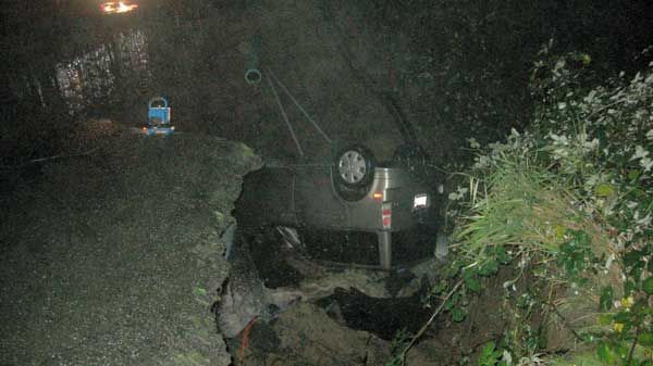
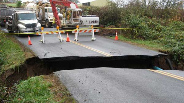
Man barely escapes as car plunges into Washington sinkhole


A man got out of his car just before it fell into a huge sinkhole in the middle of a La Center road early Saturday.

Just before 2 a.m., 47-year-old James Sandvik of La Center was driving down Northeast Charity Road when his car got stuck on the edge of a ravine that was caused by a wash out.


Sandvik got out of the car with minor injuries just before it plunged over the edge. The car then washed more than 1000 feet away as water continued to pour through a broken pipe caused by a plugged colvert, said Sgt. Alex Schoening with the Clark County Sheriff's Office.


The hole is at the 31000 block of NE Charity road, which connects to Lockwood Creek Road and runs south to Battle Ground. Traffic is detoured three miles and the road is expected to be closed for a long time.


Authorities urge drivers to avoid the area if possible.


Louisiana Sinkhole ‘Burps’. Official: Earth moved under giant sinkhole for 4 minutes straight – Before Crude oil disgorged “the water level dropped by about 6 inches”…

BAYOU CORNE, LA (WAFB) – Officials with the Assumption Parish Police Jury say the giant Louisiana sinkhole in Bayou Corne “burped” around 11:30 a.m. Tuesday. A few trees in the southwest corner of the sinkhole fell in during the event and vegetative debris and hydrocarbons came up from below the sinkhole. Texas-Brine removed all crews from the sinkhole and is checking the boom surrounding the area to make sure everything is intact


WAFB 9 News Baton Rouge, Louisiana News, Weather, Sports


Thailand
Nov 19, 2012


 Tuesday, Nov. 13, 2012

Huge sinkhole opens up in Windermere neighborhood


ORANGE COUNTY, Fla. — 
A huge sinkhole has opened up in one Windermere neighborhood and has residents on alert.
Officials said the hole is over 50 feet wide and 10 feet deep, but it isn't threatening any homes on Wax Berry Court.
An engineer is at the scene, trying to determine if the hole is getting bigger.
"Big [and] deep. The walls of the septic tank are hanging right there," said homeowner Paul Padfield.
Padfield didn't notice anything strange when he took his 8-year-old son Alex to school Monday morning, but he said they came home to the sinkhole.
Padfield said the view from his home has changed dramatically.
"There are dents all over the place. You've got little sinkholes all over," Padfield said.
Engineers said they spent Monday afternoon measuring the sinkhole and looking for shifts in the ground.


by Khan, Ning


EXPLANATION?

HERE'S ONE...

Stretch zone incidents - where rock pulls apart or snaps, creating booms and vibrations and hums, dropping bridges that lose their moorings or snapping gas and water mains, or creating sinkholes or crevasses - are not considered earthquake incidents. Quakes occur when rock borders slide along each other or push under one another, creating a jolt or a series of jolts. Stretch zone accidents  only happen when major plate movement is occurring, and are usually silent so do not get the attention that jolting earthquakes get. A bridge slips off its mooring and is attributed to heavy trucks or poor construction. A sinkhole appears and is attributed to ground water erosion. A building implodes and is attributed to settling, even though the building may have been there for centuries.


Mexico giant earth cracks, 3rd time in weeks: House swallowed, people panic


""It felt like an earthquake, everything moved, the ground started to open. We got scared because we saw the house as it collapsed. We were outside, saw the house collapsing and ran."
This is not the first, but one of many occurrences of this type in Mexico, which is definitely in a stretch zone.
For example, on Sunday, July 1, 2012, a gigantic crack opened in the earth in Dolores Hidalgo, Guanajuato. The land suddenly sank creating a crack about 13 ft. (4 m) wide by 196 ft. (60 m) deep, and 9 miles (15 km) long. Another hole also opened to one side of the first crack. It was so deep that the bottom of it could not be seen."
Mexico land cracks up; house swallowed, people panic

Mexico; house swallowed


Are the Earth's poles shifting in 2012?

Pole shift refers to a geological phenomena in which the Earth's outermost layers move together as one piece.
Image © HowStuffWorks.com

Some say the world will end in fire; some say ice. Lately, screenwriters and apocalypse enthusiasts have preferred natural cataclysms as their world-killers. As for when the end will arrive, those folks who claim to be in the know have an affinity for stamping 2012 as the Earth's sell-by date.
Why 2012? The answer traces back to true believers' interpretations (and reinterpretations) of Nostradamus, Edgar Cayce and various other ambiguous and nonscientific sources. Some armchair eschatologists have narrowed the expiration date further, to Dec. 21, 2012 -- when, they argue, the Mayan Long Count calendar ends its 5,125-year cycle. However, experts agree that the Mayans themselves did not believe that the world would end on this date, so feel free to buy green bananas on Dec. 19, 2012 [source:MacDonald].
The lack of scientific evidence for the coming apocalypse hasn't deterred believers from trotting out scientific theories to serve as evidence of imminent mass destruction. One of the most remarkable ideas they've chosen to flog is the pole shift hypothesis, in which the Earth's crust and mantle (or outermost layers) move as one piece. Pole shift might send the poles sliding toward the equator, swing North America poleward or produce any arrangement that might result from turning a globe in your hands.
People have been batting around some version of the pole shift hypothesis since at least the mid-19th century and, although many of the scientific questions it attempted to answer have since been addressed by plate tectonics, it's rooted solidly in physics. Plate tectonics and pole shifts interact and are governed by the same forces, but pole shifts, in which the outer shell of the world moves as one piece, produce very different results than plate tectonics, in which pieces of the Earth's crust bump, grind and slide -- opening seas, building mountain ranges and rearranging continents.
If a large pole shift could happen suddenly, the redistribution of land and water it caused would be nothing short of cataclysmic. In the short term, it would mean earthquakes, strange weather patterns, massive tsunamis capable of drowning parts of continents, and possibly gaps in the planet's magnetic field -- our shield against harmful cosmic rays. In the long term, the redistribution of land and water in the tropics, subtropics and poles would fundamentally alter ocean currents and the heat balance of the Earth, resulting in widespread climatological shifts. Ice caps might melt and reform elsewhere, or remain melted, driving sea levels down or up.
All of which returns us to the question: Could such a catastrophic shift occur, and if so, will it happen in 2012? We'll tell you next -- if the world doesn't end before you click to the next page.
SOURCE: http://science.howstuffworks.com/environmental/earth/geophysics/2012-earths-poles-shifting.htm

Wednesday, August 15, 2012

Is New Zealand Sinking? UPDATED 8-15-2012

update 8-15-2012

Yes, there are many changes happening around the globe.  For this update, I am going to give you information that will effect mostly New Zealand.

The following guy is really quite a hippie and makes me laugh at that part of him, but he seems to seriously know his stuff regarding what is going on around the globe.  Take a watch...


I found that most of the links to the articles that are shown in these videos are broken links with nothing there anymore.  Why would those articles not be kept?  Weird! 


RETREAT OF THE TASMAN GLACIER

Retreat of the Tasman Glacier

·                                 Credit:

 NASA image created by Jesse Allen, using Landsat data provided by the University of Maryland’s Global Land Cover Facility and ASTER data provided courtesy of NASA/GSFC/METI/ERSDAC/JAROS, and U.S./Japan ASTER Science Team. Caption by Michon Scott.
In November 2007, New Zealand’s National Institute of Water and Atmospheric Research (NIWA) announced that ice volume in the country’s Southern Alps had shrunk nearly 11 percent over the previous 30 years. NIWA scientists attributed the glacial retreat primarily to global warming and stated that, in the absence of substantial climate cooling, 12 of the largest glaciers would not recover to their previous sizes.
Three of these twelve large glaciers appear in this pair of images. Tasman Glacier, on New Zealand’s South Island, is the nation’s longest glacier. The Thematic Mapper on NASA’s Landsat 4 satellite acquired the top image on December 30, 1990, and the Advanced Spaceborne Thermal Emission and Reflection Radiometer (ASTER) on NASA’s Terra satellite acquired the bottom image on December 6, 2007. Both pictures were taken during New Zealand’s late spring or early summer. In these false-color images, pale blue indicates ice and snow, electric blue indicates water, green indicates vegetation, and brown indicates rock or bare ground.
Although composed of ice, the glacier snouts in this image appear dirty gray-brown. The color results from literal dirt. As glaciers move, they pick up rocks and debris and carry it with them downstream. Upstream from their drab exteriors, the Hooker and (especially) Tasman Glaciers are more pristine; a pale blue streak on the Hooker glacier attests to its icy interior. The dark coatings on these glaciers absorb more of the Sun’s energy and can lead to faster melting, but if the insulating layer of dirt and debris is thick enough, it can actually insulate the ice and slow the melting process.
In the 1990 image, a small lake rests at the snout of each glacier. According to NIWA scientists, these glacier-snout lakes increase the likelihood that chunks of ice will break off the glacier. In addition, the water blocks the glacier’s future advance. In the 2007 image, both glacier-snout lakes had grown, especially that of the Tasman Glacier. NIWA scientists stated that this glacier had retreated by 5 kilometers (about 3 miles) over the previous three decades. They also stated that New Zealand glaciers on the whole had lost 5.8 cubic kilometers (roughly 1.4 cubic miles) over the same time period.

Crack in the Antarctic!

From the University of Texas at Austin, a press release to tell us the ice shelves in the Antarctic peninsula are losing their grip and cracking a bit. That could be tragic, except, well, sea ice in Antarctica is growing.
And, there’s only a 40 year historical context for these observations. I just can’t too excited about this.  – Anthony
West Antarctic Ice Shelves Tearing Apart at the Seams
Posted on March 26, 2012
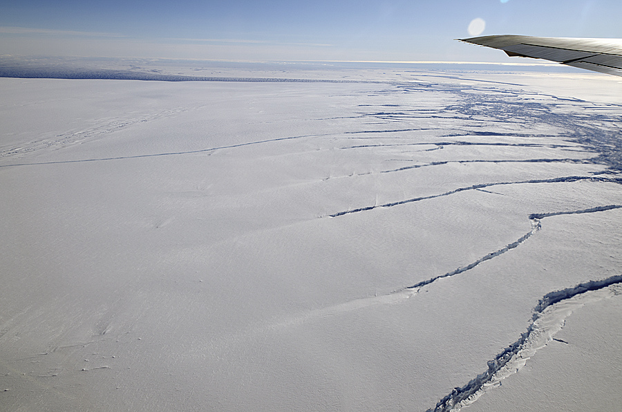
Rifts in Pine Island Glacier 2011
Rifts along the northern shear margin of Pine Island Glacier (upper right of image). Credit: Michael Studinger, NASA’s Operation IceBridge.
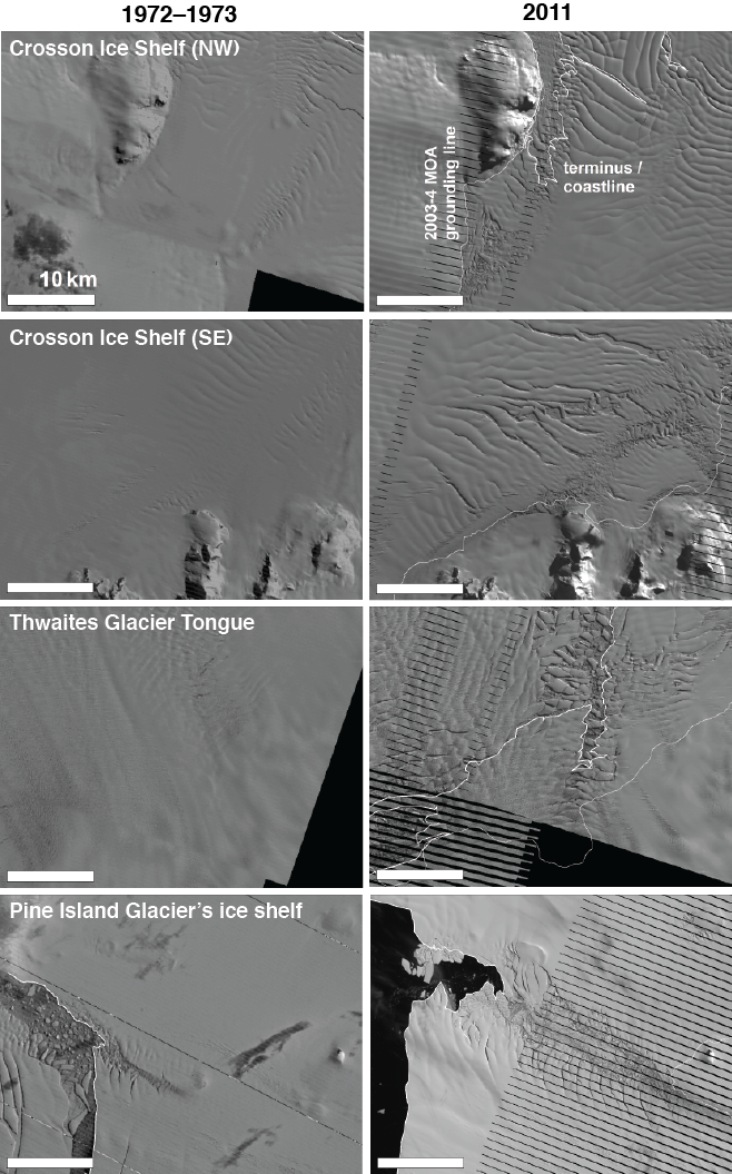
A new study examining nearly 40 years of satellite imagery has revealed that the floating ice shelves of a critical portion of West Antarctica are steadily losing their grip on adjacent bay walls, potentially amplifying an already accelerating loss of ice to the sea.
The most extensive record yet of the evolution of the floating ice shelves in the eastern Amundsen Sea Embayment in West Antarctica shows that their margins, where they grip onto rocky bay walls or slower ice masses, are fracturing and retreating inland. As that grip continues to loosen, these already-thinning ice shelves will be even less able to hold back grounded ice upstream, according to glaciologists at The University of Texas at Austin’s Institute for Geophysics (UTIG).
Reporting in the Journal of Glaciology, the UTIG team found that the extent of ice shelves in the Amundsen Sea Embayment changed substantially between the beginning of the Landsat satellite record in 1972 and late 2011. These changes were especially rapid during the past decade. The affected ice shelves include the floating extensions of the rapidly thinning Thwaites and Pine Island Glaciers.

“Typically, the leading edge of an ice shelf moves forward steadily over time, retreating episodically when an iceberg calves off, but that is not what happened along the shear margins,” says Joseph MacGregor, research scientist associate and lead author of the study. An iceberg is said to calve when it breaks off and floats out to sea.
“Anyone can examine this region in Google Earth and see a snapshot of the same satellite data we used, but only through examination of the whole satellite record is it possible to distinguish long-term change from cyclical calving,” says MacGregor.
The shear margins that bound these ice shelves laterally are now heavily rifted, resembling a cracked mirror in satellite imagery until the detached icebergs finally drift out to the open sea. The calving front then retreats along these disintegrating margins. The pattern of marginal rifting and retreat is hypothesized to be a symptom, rather than a trigger, of the recent glacier acceleration in this region, but this pattern could generate additional acceleration.
“As a glacier goes afloat, becoming an ice shelf, its flow is resisted partly by the margins, which are the bay walls or the seams where two glaciers merge,” explains Ginny Catania, assistant professor at UTIG and co-author of the study. “An accelerating glacier can tear away from its margins, creating rifts that negate the margins’ resistance to ice flow and causing additional acceleration.”
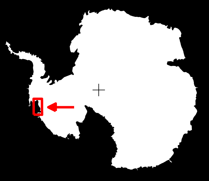
Amundsen Sea Embayment Map
Location of Amundsen Sea Embayment
The UTIG team found that the largest relative glacier accelerations occurred within and upstream of the increasingly rifted margins.
The observed style of slow-but-steady disintegration along ice-shelf margins has been neglected in most computer models of this critical region of West Antarctica, partly because it involves fracture, but also because no comprehensive record of this pattern existed. The authors conclude that several rifts present in the ice shelves suggest that they are poised to shrink further.
This research is sponsored in part by the National Science Foundation.

West Antarctic Ice Shelves – Then and Now

(click to download high resolution version):
West Antarctic Ice Shelves Then and Now
Pairs of Landsat satellite images showing changes in ice shelf margins in the eastern Amundsen Sea Embayment in West Antarctica between 1972 and 2011. The striping visible in the 2011 images is due to an unrepaired malfunction in the Landsat-7 platform that occurred in 2003.
=============================================================
UPDATE: Gail Combs adds this background info in comments:
Velocities of Pine Island and Thwaites Glaciers, West Antarctica, From ERS-1 SAR images
ABSTRACT:
Average velocities of Pine Island and Thwaites Glaciers were measured for the time periods between 1992 and 1994 by tracking ice-surface patterns. Velocities of the central flow of the Pine Island Glacier range from 1.5 km/yr above the grounding line (separating the grounded from the floating parts of a glacier) to 2.8 km/yr near the terminus; velocities of the central Thwaites Glacier range from 2.2 km/yr above the grounding line to 3.4 km/yr at the limit of measurements on the tongue. Both glaciers show an increase in velocity of about 1 km/yr where they cross their grounding lines. The velocities derived from ERS-1 images are higher than those previously derived from Landsat images, perhaps reflecting acceleration of the glaciers. Both glaciers are exceptionally fast. The high velocities may be due to high precipitation rates over West Antarctica and the lack of a major buttressing ice shelf.
Keywords: ERS-SAR images, Pine Island Glacier, Thwaites Glacier, glacier velocity, glacier tongue, glacier terminus
http://earth.esa.int/workshops/ers97/papers/lucchitta/
Antarctic volcanoes identified as a possible culprit in glacier melting
…”This is the first time we have seen a volcano beneath the ice sheet punch a hole through the ice sheet” in Antarctica, Vaughan said.
Volcanic heat could still be melting ice to water and contributing to thinning and speeding up of the Pine Island glacier, which passes nearby, but Vaughan said he doubted that it could be affecting other glaciers in western Antarctica, which have also thinned in recent years. Most glaciologists, including Vaughan, say that warmer ocean water is the primary cause of thinning.
Volcanically, Antarctica is a fairly quiet place. But sometime around 325 B.C., the researchers said, a hidden and still active volcano erupted, puncturing several hundred yards of ice above it. Ash and shards from the volcano carried through the air and settled onto the surrounding landscape. That layer is now out of sight, hidden beneath the snows that fell during the next 2,300 years…..
http://www.nytimes.com/2008/01/20/world/europe/20iht-climate.4.9358350.html
comment: 
E.M.Smith says:
Golly, ice shelves break up. I’m shocked…
(Last thing I’d want to see is ice shelves extending and never breaking, if that ever happens, we’re headed for Iceball Earth again…)
Two added notes:
1) Isn’t this on / near the warming peninsula? That part of Antarctica to have a bunch of volcanoes and warming dirt under the ice? As the rest of Antarctica is getting colder, to have ice growing where it’s colder and breaking off a bit where the land is warming seems quite reasonable.
2) With the solar sleepy time the UV dropped. That let the air column shorten. I’ve observed a return of the stronger more blustery winds of the 1950s and ’60s (and potentially a bit more so). Now assuming this holds near Antarctica too (do we have wind data there?) that would lead to larger waves and a faster circumpolar current. I’d fully expect that to put more ‘tearing’ force on an ice shelf; and more up / down flexing fracturing the margins too. Do we have circumpolar current speed data anywhere? ( IMHO, the spike of cold water we saw in the last few years out into the central Pacific from S. America is evidence for a faster circumpolar current whacking into Drake Passage and sending the ‘excess’ up the coast of S. America. To the extent that is true, the Antarctic side of Drake Passage ought to be getting more currents and pressure too.)
So I think it’s an interesting observation on the ice sheet and land mooring at the margins, but think it’s more likely related to #1 and #2 above and unrelated to air temperatures. 

National Snow & Ice Data Center (NSIDC) – click to view at source
A aerial view of the Mertz Glacier tongue breaking off from a glacier in Antarctica after being rammed by another giant iceberg, February 20, 2010. REUTERS-Neal Young-Australian Antarctic Division

SINGAPORE | Fri Feb 26, 2010 9:05am EST
(Reuters) - An iceberg the size of Luxembourg has broken off from a glacier in Antarctica after being rammed by another giant iceberg, scientists said on Friday, in an event that could affect ocean circulation patterns.
The 2,500 sq km (965 sq mile) iceberg broke off earlier this month from the Mertz Glacier's 160 km (100 miles) floating tongue of ice that sticks out into the Southern Ocean.
The collision has since halved the size of the tongue that drains ice from the vast East Antarctic ice sheet.
"The calving itself hasn't been directly linked to climate change but it is related to the natural processes occurring on the ice sheet," said Rob Massom, a senior scientist at the Australian Antarctic Division and the Antarctic Climate and Ecosystems Cooperative Research Center in Hobart, Tasmania.
Both organizations, along with French scientists, have been studying existing giant cracks in the ice tongue and monitored the bumper-car-like collision by the second iceberg, B-9B.
This 97 km long slab of ice is a remnant of an iceberg of more than 5,000 sq km that broke off, or calved, in 1987, making it one of the largest icebergs ever recorded in Antarctica.
The Mertz glacier iceberg is among the largest recorded for several years. In 2002, a iceberg about 200 km long broke off from Antarctica's Ross Ice Shelf. In 2007, a iceberg roughly the size of Singapore broke off from the Pine Island Glacier in West Antarctica.
Massom said the shearing off of the ice tongue and the presence of the Mertz and B-9B icebergs could affect global ocean circulation.
The area is an important zone for the creation of dense, salty water that is a key driver of global ocean circulation. This is produced in part through the rapid production of sea ice that is continually blown to the west.
"Removal of this tongue of floating ice would reduce the size of that area of open water, which would slow down the rate of salinity input into the ocean and it could slow down this rate of Antarctic bottom water formation," he said.
He said there was a risk both icebergs would become grounded on banks or shoals in the area, disrupting the creation of the dense, salty water and the amount that sinks to the bottom of the ocean, he said.
Oceans act like a giant flywheel for the planet's climate by shifting heat around the globe via myriad currents above and below the surface.
(Reporting by David Fogarty; Editing by Alex Richardson)

Arctic Sea Ice Concentration – Same Date Compared With 2007
http://home.comcast.net/~ewerme/wuwt/cryo_compare_small.jpg
Cryosphere Today – Arctic Climate Research at the University of Illinois – Click the pic to view at source (thanks to Ric Werme)

NCDC, US temps since 1940

Residents fight to keep sinking home
Published: 8:56PM Thursday August 02, 2012 Source: One News/Close Up
Three Rotorua homeowners say they are willing to fight the Rotorua District Council to keep their dream homes.
Just a few years after the Ngongotaha residents moved in to their homes they began sinking and cracking.
Despite the ground they are built on being soft and unstable, Rotorua District Council signed it off as being suitable to build on.
Documents obtained by Close Up show that the council was well aware of the ground stability issues in the earliest days of the subdivision's completion.
Close Up has a copy of a legal document which describes the situation just after the first houses were built as "fraught with all sorts of potential difficulties".
..."Well we moved in and slowly the house has been tipping over."

Neighbour John Grundy agreed saying that the  "Rotorua District Council must accept responsibility for its mistakes".
Ngongotaha resident Richard Davis said that one side of his house in dropping in one direction, while the opposite side of the house is dropping in the other direction.
Grundy said: "It's pulling the house apart and this is after four years.
"It's not Christchurch, but the house is sinking."
Here is an interesting conversation on the topic...


------------------end update----------------

Liquefaction following earthquake in New Zealand


Geoff Sloan / New Zealand Herald via AP
This aerial photo shows the Burwood and New Brighton areas damaged by liquefaction after a 5.8-magnitude quake struck Christchurch, New Zealand, Friday Dec 23, 2011. A series of strong earthquakes struck Christchurch on Friday, rattling buildings, sending goods tumbling from shelves and prompting terrified holiday shoppers to flee into the streets. There was no tsunami alert issued and the city appeared to have been spared major damage.

Simon Baker / Reuters
Sewage (bottom and right) spreads past a car trapped in a sink hole caused by liquefaction in the Christchurch suburb of Parklands after an earthquake struck December 23, 2011.
A series of strong earthquakes struck the New Zealand city of Christchurch on Friday, rattling buildings, sending goods tumbling from shelves and prompting terrified holiday shoppers to flee into the streets. There was no tsunami alert issued and the city appeared to have been spared major damage. Continue reading...
Continue reading...

Christchurch rocked by earthquakes

By NZHERALD STAFF and APNZ
3:02 PM Friday Dec 23, 2011
View Larger Map
Residents try to free a car stuck in a liquefaction sink hole in Bower Avenue, Parklands, after today's quakes. Photo / Geoff Sloan

Residents try to free a car stuck in a liquefaction sink hole in Bower Avenue, Parklands, after today's quakes. Photo / Geoff Sloan

A series of earthquakes have terrified many already-frazzled Christchurch residents this afternoon, starting with a 5.8 magnitude tremor at 1.58pm.
It was followed by a 6.0 magnitude aftershock at 3.18pm, centred 10km east of Christchurch in South New Brighton.
There was also a 5.3 magnitude quake at 2.06pm and a 5.0 at 4.50pm.
Initial reports said one person had received minor injuries, although St John had responded to 19 earthquake-related emergency calls in and around Christchurch.
They ranged from complaints of chest pain and seizures, to a panic attack.
Five people had collapsed, and one suffered a knock to the head.
St John said all injuries were minor.
Police say there is no tsunami threat, and they have no reports of serious or widespread damage or injury.
Civil Defence staff have met on the ground in Christchurch to get a good picture of the extent of impact, but national civil defence controller David Coetzee said it was too early to comment on the way forward.
He said while there were no reports of serious damage, buildings that were already weakened in previous earthquakes may have sustained further damage.
"There will be further aftershocks. This event pretty much takes the pattern of the June event," he said, referring to a strong aftershocks in Christchurch that month.
"Be aware of further aftershocks. Drop, cover and hold remains the old mantra. Look after each other, look after the neighbours, stay safe and call 111 or the council if you need help."
Rockfalls and damage
People were urged to stay away from hill suburbs because of risk of rockfalls, and Coastguard had rescued four people who were trapped by rockfall in Boulder Bay.
Police said there had also been a significant rockfall at Redcliffs, a stopbank on New Brighton Road had collapsed, a partly demolished building on the corner of Barbadoes and Kilmore Streets collapsed, and a vacant house at 81 Aynsley Terrace collapsed.
Some residents at Windsor Hospital rest home in New Brighton were trapped on the second floor of the building, but are being evacuated by the Fire Service.
There has been significant flooding and liquefaction in the eastern suburbs including Avonside and Bexley.
The India Blue restaurant in Sumner is damaged and has been cordoned off and a building on the corner of Charles Street and William Street in Kaiapoi is at risk of collapse.
Road damage and liquefaction
Major holes in the road were reported to have opened up on Broadhaven Avenue, and liquefaction was reported in Avonside.
Drivers were urged to slow down and be patient as congestion built up in some areas.
Police said Christchurch residents should stay off roads if at all possible, and text rather than phone.
Christchurch Hospital, the Princess Margaret Hospital and Hillmorton are all fully operational. Burwood is operating on emergency power.
There are no reports of damage and no injuries to staff or patients who were at the board's facilities at the time of the quake.
The DHB said people can access 24-hour non-emergency care through their general practice, and are asked to help keep the Emergency Department clear for genuine emergencies. The 111 service is operating normally for emergencies.
The Christchurch mayor said his heart breaks for Cantabrians shocked by a series of earthquakes this afternoon.
The first, a magnitude 5.8 tremor, struck at 1.50pm. Its focal point was at a depth of eight kilometres, 20km off the coast of Lyttelton.
Airport evacuated
Christchurch Airport remains evacuated, with literally hundreds of people standing outside with their luggage.
Newstalk ZB reporter Scarlett Cvitanovich says nobody knows when they'll be able to go back inside.
"There's quite a bit of aggression out there. People are asking how they're going to get on flights in time for Christmas and are taking it out on staff at the moment," she says.
Flights bound for Christchurch are also being diverted to other cities.
Key: 'My heart goes out to the people of Christchurch'
Prime Minister John Key said Canterbury Earthquake Recovery Minister, Gerry Brownlee, will be heading to Christchurch this afternoon to access the situation.
"My heart goes out to the people of Christchurch and Canterbury at this time," Mr Key said.
"However, residents can be confident that the authorities are onto the situation and government resources stand ready to assist wherever they are needed.
"The Government's resolve to work with the people of Christchurch and Canterbury to rebuild remains unchanged following today's two aftershocks."
Mayor Bob Parker has now booked to fly back to Christchurch from Taupo, where he was holidaying.
He told TVNZ he was getting a lot of reports in from the east of the city of minor damage.
"On the east there's more reports coming in of liquefaction, in Avondale ... and there's small collapses around riverbanks."
He said while initial reports tell of minor damage to the city, today's shake would have taken a large emotional toll on people.
"Many of them just sitting around and in tears. You just can't understand the ongoing stress."
"We were just getting over that feeling, I think, and it sets people back."
Chlorine had finally been removed from the waterways two weeks ago, and today's quake could have set infrastructure progress back, he said.
'Very violent... constant rolling'
Jacqui Taylor said she was working in the Lyttelton library when the first magnitude 5.8 quake hit.
"It was very violent, with constant rolling for a very long time, we left the building and people gathered in the main street. there were more aftershocks while we were in the street.
"I luckily made it through the tunnel and back home in Addington, feeling one more shake while i was in my car at the lights."
Power outages
Electricity distributor Orion said, following the 3.18pm magnitude 6.0 aftershock, power was again tripped to the Eastern Suburbs of Christchurch and to the rural central Canterbury area around Springston.
Around 26,000 customers remain without power in eastern Christchurch. Power is out from the New Brighton area through to Shirley.
Orion said its crews were out assessing damage. It said it appeared power is out due to tripping caused by shaking rather than damage to equipment.
Neanwhile New Zealand Post said there will be no mail deliveries in Christchurch. The Christchurch Mail Centre has been evacuated as a precaution and will not re-open this evening.
The next scheduled mail deliveries following the statutory holidays will be December 28.
Emergency Operations Centre
The Christchurch City Council has established an Emergency Operations Centre in the city. There has been a rockfall behind containers at Scarborough, and liquefaction at Parklands, the council said.
Police are doing aerial reconnaissance to check for damage across the city.
All Council buildings will be closed until they can be assessed as safe to occupy. People should assume all Council buildings are closed until they can be assessed and declared safe.
Cantabrians are being warned that more aftershocks could be on the way before Christmas.
GNS: More aftershocks to come
GNS seismologist Ken Gledhill told TVNZ "this is part of a series of earthquakes that have been set off by what happened in September 2010.
"In the coming days the most likely scenario is that there will be a series of aftershocks in a similar location.
"This is just a reminder that this area is more active than what it was before September 2010."
He said GNS were doing the best they could with information and the situation in Christchurch.
- APNZ http://www.nzherald.co.nz/nz/news/article.cfm?c_id=1&objectid=10775043

More Chch areas could face red-zone revision

Published: 6:39AM Saturday December 24, 2011 Source: ONE News
  • More Chch areas could face red-zone revision (Source: Reuters)
    Darryl Freeman shovels liquefaction from in front of his house in Parklands - Source: Reuters
    More Chch areas could face red-zone revision (Source: ONE News)
    Liquefaction following Christchurch earthquakes - Source: ONE News
There is the possibility more areas of Christchurch could be red-zoned after yesterday's strong earthquakes.
Christchurch was rocked by two powerful tremors in quick succession yesterday afternoon, which forced evacuations from buildings.
Since midnight there have been 23 aftershocks, with the last one just before 2.30pm. Many of today's shakes were around magnitude 3, but the biggest, at 6:37am this morning, was magnitude 5.1.
Most of the quakes were centred around the same area - off the coast, about 10 kilometres east of Christchurch.
The ongoing tremors mean many areas of Christchurch are still dangerous.
The Port Hills pose a risk of rock falls, and authorities are urging people to steer clear, unless they live there.
In the eastern suburbs, many residents are cleaning up liquefaction for the third, fourth or even fifth time this year.
Parklands residents have told ONE News that they want their land rezoned red once and for all.
"We've had enough - we can't keep doing this, this will happen again, and again," said resident Geoff Cooke.
The rezone will mean that instead of getting individual geo-tech reports on each property - the whole area would be zoned uninhabitable.
"We've had this three times now, you've seen the volume of liquefaction coming out of our ground," Cooke adds.
"It doesn't matter what the foundation types are, they'll keep the houses plum all right, but they'll keep sinking into the ground, it's an absolute waste of time in this area."
In response, the government stated today that engineers will return to the area in the new year once the water subsides - leaving a better picture of the land damage.
Another Parklands resident told ONE News he is all for a rezone.
http://tvnz.co.nz/national-news/christchurch-jolted-early-morning-5-1-shake-4668248