Coincidence? PsyOp? HAARP? Testing their equipment? Do the authorities actually know that there is a cycle and they are just not alerting the public? Just read, watch, and ponder...
From the following poster...
Uploaded by thetruthergirls on Mar 23, 2012The recent earthquake in Oaxaca, Mexico, on time in accordance with a188-day major quake cycle, was it caused by HAARP, or was it just a random geological event?
http://www.cbc.ca/news/world/story/2012/03/20/mexico-earthquake.html
http://www.godlikeproductions.com/forum1/message1814464/pg1
http://commonsenseconspiracy.com/2012/03/187-or-188-day-earthquake-cycle-theo...
http://earthquake.usgs.gov/earthquakes/eqinthenews/
http://www.timeanddate.com/date/dateadded.html?m1=3&d1=20&y1=2012&...
http://beforeitsnews.com/story/1915/939/HAARP_Mexican_Earthquake_Mega-Simulat...
http://forum.prisonplanet.com/index.php?topic=155697.0
http://chemtrailsnorthnz.wordpress.com/2011/02/24/admiral-thad-allen-in-chris...
http://www.voxy.co.nz/national/statement-fema-administrator-craig-fugate-rega...
-----------------------------end update-------------------------------------------
Was the large earthquake in Mexico pre-planned? The following information seems to point in that direction. As always, I did find the following information on the Internet, so I cannot vouch for the complete truthfulness and accuracy, however, the information is compelling.
Chiapas Governor 6 minutes before earthquake: “Everything is ready for the 7.9 Richter scale earthquake simulation.”
Mario Andrade
Deadline LiveMarch 22nd, 2012 The Mexican State of Chiapas held a ‘mega earthquake drill’ just minutes before the 7.8 Richter scale earthquake registered in Southern Mexico, according to the news website ADNPolitico.com.
Governor Juan Sabines Guerrero sent a message from his Twitter account just six minutes before the actual earthquake. The translation of the message is the following:
“We’re at the State of Chiapas Civil Protection Center. Everything is ready for the 7.9 Richter scale earthquake simulation.”
Six minutes later, and about 500 kilometers west of Chiapas, in the neighboring southern state of Guerrero, a 7.8 magnitude earthquake was registered. The earthquake was so massive that over a hundred aftershocks were felt throughout the following day.
The Chiapas Civil Protection ‘mega earthquake simulation’ was planned since last February, according to state officials. The purpose of this drill was to test the responsiveness of the State Civil Protection System and the general public upon the occurrence of a large scale earthquake, and to allow the exercise participants to evaluate and provide feedback on first response protocol.
The Chiapas state government said that this geographical area is located in a region between three tectonic plates: The Cocos Plate, the Caribbean Plate and North American Plate.
State officials also emphasized that earthquakes are very common in that region. “Just in January, there were 188 earthquakes with epicenter in this state, over 50% of registered earthquakes in the country. That’s why we must be prepared to avoid or reduce undesirable effects of these earthquakes.” said a Chiapas state official.
The mega earthquake drill involved nearly 43,000 public officials and more than 19,600 school facilities. A list of documents, details of the simulation, location, and the drill schedule can be found on the Chiapas Civil Protection Website.
This is a picture of the first page of the site, translated into English.
Here is the video regarding the simulation...
How did the simulation turn into the real deal?
Was this just coincidence or was there an instrument used, such as HAARP to create the big earthquake?
Perhaps we will never know.
However, what has happened is that this earthquake, real or man made, has set off a swarm of earthquakes. Here is the scoop...
Awakening? 7.4 Mexico earthquake sets off seismic swarm at San Salvador volcano
Posted on March 22, 2012  March 22, 2012 – SAN SALVADOR – The National Service of Territorial Studies, which is known as SNET is reporting that 8 earthquakes have rattled the San Salvador Volcano which is located northwest of the capital city of San Salvador- a population of about 540,000 people. An emergency declaration has been declared at the volcano as a precautionary measure. The eight tremors felt by the population have reached levels of between 2.2 and 3.3degrees on the Richter scale, according to the National Service of Territorial Studies (SNET), which has also recorded at least 25 micro-earthquakes. The Ministry of Environment and Natural Resources in a statement recalled that the last seismic swarm with epicenter in the San Salvador volcano was in 2007, when there were 142 micro-earthquakes, four of them felt by the population. The volcano last erupted in 1917. The volcano is believed to have sprung to life after a 7.4 magnitude earthquake struck the Oaxaca region of Mexico. According to the National Seismological Service (SSN), the massive Mexico earthquake unleashed more than 44 aftershocks as of Wednesday. Of the aftershocks recorded by the country, six were over 5.0 + magnitude on the Richer scale and 25 were of a 4.0 magnitude, with the rest 3.0 or smaller. Apart from the string of earthquakes in San Salvador, today SNET reported another quake of 4.3 on the Richter scale at 11.26 local time (17.26 GMT) in the Pacific Ocean, about 43 kilometers south of the estuary San Diego, in the department of La Libertad. This other quake had a focal depth of 34 miles and reached an intensity of three on the Mercalli scale in San Salvador. The Salvadoran authorities have reported no casualties or damage resulting from earthquakes. –Univision (translation)
Another interesting tidbit that I found on this is that, following the large quake, seismographs around the globe went crazy, like a wave of seismic activity had hit them.
Global Seismic Readings After Mexico Quake....,
Okay, this is a display from one of my websites where I have near real-time seismic displays for all over the world. This page is the United States, but I also have all other regions and they all show the same thing. All stations either show this ....chaotic mass of activity or they show an abrupt end to the trace.
Now, I'm not feeling anything physical here so it can't be how it appears...There must be another cause for this. Incidentally, when I say everywhere, even Antarctic seismic stations recorded this, and recorded that blur of scribbles just a bit different than every other station. That is the other thing, every station has this just a little different, just as they ALL record actual quakes just a bit different from all the rest....
Anyone have ideas of what causes this on every Seismic display across the world? This WAS NOT here a few minutes after the Mexico Quake, by the way... I'd checked all my displays and saw the 7.6 quake on clear charts....this all came after. ??
Let's keep an eye on what continues to happen on the earthquake front and see if this quake triggers more events. This is all very interesting, isn't it!!!

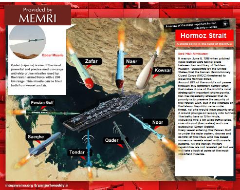 The infographic simulates an attack on a U.S. aircraft carrier in the Strait of Hormuz using IRGC missiles, including the Nasr (3 ton cruise missile with anti-ship capabilities), Zafar (short range radar guided missile fired from swift watercraft), Khalij-e Fars (solid fuel ballistic missile with a range of 300 km), Saeqhe (a missile with a range of 300 km), Tondar (a ballistic missile fired from land), Qader (a cruise missile with a range of 200 km, designed for aircraft and watercraft), Noor (A surface-to-sea or sea-to-sea missile with a range of 170 km), and Kowsar (a surface-to-sea, sea-to-sea, and air-to-sea medium range, radar and TV guided missile).


