Update: 3-27-2013: Fracking. Causing Earthquakes. Damaging Buildings and Houses. Contaminating Water.
3/26/2013 — Oklahoma 5.6M earthquake in 2011 — determined to be “man made”
video here:
March 26, 2013 :
WASHINGTON (AP) — A team of scientists have determined that a 5.6 magnitude quake in Oklahoma in 2011 was caused when oil drilling waste was injected deep underground.That makes it the most powerful quake to be blamed on deep injections of wastewater, although not everyone agrees. Oklahoma’s state seismologists say the quake was natural.The Nov. 6 earthquake near Prague, Okla., injured two people, damaged 14 houses and was the strongest Midwestern quake in decades.The new report says there was a smaller quake at the site of an old injection well, and that triggered the larger tremor. Records show the well pressure rising dramatically in 2006. The scientists say both combine to make a strong case that waste injections caused the quake.The report was released Tuesday by the journal Geology.
—————-
Fracking induced earthquakes / injection well earthquakes — are becoming a menace as of late…
Here is my video from 2011 the same day of the actual earthquake….. ironic indeed it took the professionals 2 years to figure this out… they must not have google earth access ! 
here is my post on the day of the earthquake:
here is the picture from 2011 that I uploaded clearly showing the earthquake to be inside of a large fracking / injection well operation:

—————
Here are all my past posts on fracking earthquakes in the United States / Europe:
Earthquakes in Oklahoma? Is 'fracking' to blame, or something else?
Recent earthquakes in Oklahoma – the largest a magnitude 5.6 – are part of a 'swarm' of temblors to rattle the state since 2009, say geophysicists. Research suggests that the quakes are too big to chalk up to fracking to extract oil and gas.

Chad Devereaux works to clear up bricks that fell from three sides of his in-laws' home in Sparks, Okla., Sunday, after two earthquakes hit the area in less than 24 hours. The weekend earthquakes were among the strongest yet in a state that has seen a dramatic, unexplained increase in seismic activity.
Sue Ogrocki/AP
Indeed, this week's temblors in the Sooner State highlight the challenge scientists face as they try to improve earthquake-hazard assessments in the central and eastern United States, particularly across the lower half of the country.
In regions known for relatively frequent, large quakes, such as the west coasts of North and South America or deep in the heart of Turkey, sources of stress on faults are well known. And the faults themselves are increasingly well-studied, allowing scientists to estimate repeat rates for major temblors along these shifting cracks in Earth's crust.Indeed, this week's temblors in the Sooner State highlight the challenge scientists face as they try to improve earthquake-hazard assessments in the central and eastern United States, particularly across the lower half of the country.
In the middle of the continental US, however, research over the past decade suggests that trying to estimate future quake activity may be more like a high-stakes game of "Whac-A-Mole."
One fault system might generate a cluster of quakes over a period of a few years, then it delivers diminishing set of aftershocks for centuries while stress migrates to a new fault system, explains Seth Stein, a geophysicist at Northwestern University in Evanston, Ill.
The past of any one fault system may not be a prologue to its future. Trying to divine that future may represent "an exercise in closing the barn door after the horse has gone," he says.
Oklahoma sits squarely in the portion of the country that appears most susceptible to this wandering seismic activity, some studies suggest.
That's likely to be of little comfort to people rattled by this week's quakes. The first shock struck central Oklahoma early Saturday morning, with a magnitude of 4.7. This turned out to be a fore shock in advance of a magnitude 5.6 quake that struck the same fault Sunday night. The area has experienced a series of aftershocks, including another magnitude 4.7 quake Monday night. A magnitude 3.6 aftershock hit early Tuesday afternoon.
Throughout 2009 and 2010, the state has experienced unusually high earthquake activity, although the activity may be typical for the state when viewed over long periods of time, according to the state geological-survey office in Leonard.
No one has a good handle on why the activity has increased. This week's quakes may well be part of this "swarm," Dr. Stein says.
Some residents are asking whether oil and gas extraction in the state may have triggered the quakes, particularly via the practice of hydraulic fracturing, or "fracking." This involves pumping fluids into the ground to force more oil or gas out. Fluids can in effect lubricate faults, reducing the friction that may be holding back an earthquake.
Several studies in the US and overseas have found evidence that fracking and other techniques for injecting fluids into oil and gas formations have triggered small quakes, with varying degrees of certainty.
In August, for instance, researchers with Oklahoma's geological survey looked into complaints that fracking had triggered a series of small earthquakes ranging in magnitude from 1 to 2.8 south of Elmore City.
After sorting through the evidence, the survey concluded that while it was possible fracking triggered the quakes, the data available weren't good enough to support "a high degree of certainty" that fracking was the culprit.
source: http://www.csmonitor.com
-------------------------------------------------------------------------------------------------------------------------
Today....
USGS
-------------------------------------------------------------------------------------------------------------------------
Today....
USGS
| mag 2.8 | location 8km NW of Prague, Oklahoma |
date
| coordinates 35.547°N | coordinates 96.743°W | 4.7 |
| 3.2 | 1km N of Midwest City, Oklahoma | 35.467°N | 97.396°W | 5.0 | |
| 3.3 | 4km N of Midwest City, Oklahoma | 35.486°N | 97.390°W | 8.8 |
----------------------------------------------------------------------------------------------------------------------------
Did Fracking Cause Oklahoma's Largest Recorded Earthquake?
Probably not, as the gas drilling practice tends to be associated with minor quakes, not big ones, seismologists say
 QUAKE CAUSE?: Oklahoma recently experienced its strongest earthquake ever, and some suggest drilling for oil and gas may have played a role.Image: © iStockphoto.com / cstar55
The biggest earthquake ever recorded in Oklahoma struck on November 5, a magnitude 5.6 temblor that buckled a highway and ruptured water pipes. This quake is part of a skyrocketing rise in seismic activity the state has seen in the past three years, leading many to wonder—and worry—about its cause. Might the practice of fracking, a controversial method of fracturing rock to help get at fossil fuels, be to blame?*
The earthquake struck around 10 P.M. local time about 50 kilometers east of Oklahoma City, and was felt from Saint Louis to Dallas. Until then, the state's largest temblor was a magnitude 5.5 event near the town of El Reno in 1952.
Overall, only minor injuries and damage were reported after last weekend's earthquake. A magnitude 4.7 foreshock preceded the quake by about 20 hours, and dozens of aftershocks were detected as well. These all apparently happened on the well-mapped Wilzetta Fault. "It seems the east side of the fault moved a bit southward," says seismologist Randy Keller, director of the Oklahoma Geological Survey (OGS).
The recent uptick in the area's temblors has been dramatic. From 1972 to 2008 only two to six earthquakes were reported per year in Oklahoma, and were often too small for people to notice. However, in 2009 nearly 50 earthquakes were recorded (pdf), and that number more than doubled in 2010 to 1,047, with 103 powerful enough to be felt.
This unusual seismicity has led some to wonder about increased activity in the area related to fracking, or hydraulic fracturing, which uses millions of gallons of fluid to break apart rock and release natural gas. The practice generates a considerable amount of waste liquid, which is often disposed of by injecting it into deep rock formations where it can lubricate faults. Hydraulic fracturing is common in Oklahoma, the nation's third-largest producer of natural gas, and has taken place there for decades (pdf). Now, with the discovery of natural gas deposits in other regions of the U.S., the extraction method is being used more widely and has raised concerns about its potential to contaminate drinking water.
Fracking has been linked to two minor earthquakes in northwest England, very likely by lubricating an already stressed fault zone and thus making it easier for the land to shift (pdf). A report in August (pdf) by seismologist Austin Holland at the OGS also suggested that a swarm of nearly 50 small quakes of magnitude 1.0 to 2.8 near the center of the state might have been triggered by nearby fracking.
Still, researchers say it seems unlikely that fracking had anything to do with last weekend's magnitude 5.6 quake. "There was a lot of deformation of the Earth here 300 million years ago that created huge geological structures in the subsurface that shift from time to time," Keller says. "We have an unstable situation here, and it's one reason why oil and gas is available here in the first place."
"I won't say that man's activity never ever caused the release of seismic stress, but hydro-fracks are such small things," Keller adds. "If we were talking a magnitude 1 or 2 earthquake, that'd be different, but it's awfully hard to imagine a hydro-frack being involved with one of this size. We also have to determine if there were any frack jobs going on there right now, but I don't think there were—it didn't happen in an area of particularly active oil and gas exploration."
As to whether the spike in earthquakes recently seen in the state might be due to fracking, "it is probably best not to attach much significance to perceived increases in seismic activity in Oklahoma—the occurrence of earthquakes anywhere is quite irregular," says seismologist Art McGarr with the U.S. Geological Survey. This surge in quakes might be a temporary statistical anomaly.
The earthquake struck around 10 P.M. local time about 50 kilometers east of Oklahoma City, and was felt from Saint Louis to Dallas. Until then, the state's largest temblor was a magnitude 5.5 event near the town of El Reno in 1952.
Overall, only minor injuries and damage were reported after last weekend's earthquake. A magnitude 4.7 foreshock preceded the quake by about 20 hours, and dozens of aftershocks were detected as well. These all apparently happened on the well-mapped Wilzetta Fault. "It seems the east side of the fault moved a bit southward," says seismologist Randy Keller, director of the Oklahoma Geological Survey (OGS).
The recent uptick in the area's temblors has been dramatic. From 1972 to 2008 only two to six earthquakes were reported per year in Oklahoma, and were often too small for people to notice. However, in 2009 nearly 50 earthquakes were recorded (pdf), and that number more than doubled in 2010 to 1,047, with 103 powerful enough to be felt.
This unusual seismicity has led some to wonder about increased activity in the area related to fracking, or hydraulic fracturing, which uses millions of gallons of fluid to break apart rock and release natural gas. The practice generates a considerable amount of waste liquid, which is often disposed of by injecting it into deep rock formations where it can lubricate faults. Hydraulic fracturing is common in Oklahoma, the nation's third-largest producer of natural gas, and has taken place there for decades (pdf). Now, with the discovery of natural gas deposits in other regions of the U.S., the extraction method is being used more widely and has raised concerns about its potential to contaminate drinking water.
Fracking has been linked to two minor earthquakes in northwest England, very likely by lubricating an already stressed fault zone and thus making it easier for the land to shift (pdf). A report in August (pdf) by seismologist Austin Holland at the OGS also suggested that a swarm of nearly 50 small quakes of magnitude 1.0 to 2.8 near the center of the state might have been triggered by nearby fracking.
Still, researchers say it seems unlikely that fracking had anything to do with last weekend's magnitude 5.6 quake. "There was a lot of deformation of the Earth here 300 million years ago that created huge geological structures in the subsurface that shift from time to time," Keller says. "We have an unstable situation here, and it's one reason why oil and gas is available here in the first place."
"I won't say that man's activity never ever caused the release of seismic stress, but hydro-fracks are such small things," Keller adds. "If we were talking a magnitude 1 or 2 earthquake, that'd be different, but it's awfully hard to imagine a hydro-frack being involved with one of this size. We also have to determine if there were any frack jobs going on there right now, but I don't think there were—it didn't happen in an area of particularly active oil and gas exploration."
As to whether the spike in earthquakes recently seen in the state might be due to fracking, "it is probably best not to attach much significance to perceived increases in seismic activity in Oklahoma—the occurrence of earthquakes anywhere is quite irregular," says seismologist Art McGarr with the U.S. Geological Survey. This surge in quakes might be a temporary statistical anomaly.
read more at http://www.scientificamerican.com
---------------------------------------------------------------------------------------------
---------------------------------------------------------------------------------------------

Drilling wells
In July 2012 it was reported that Oklahoma officials ignored advice about injecting water into faults in an effort to extract oil and natural gas. Such injection, warns seismologists, could induce earthquakes.[1]
Click here for an interactive map of oil and gas wells.
Caney Shale, Oklahoma
The Caney Shale in the Arkoma Basin is the stratigraphic equivalent of the Barnett Shale in the Ft. Worth Basin. The formation has become a gas producer since the large success of the Barnett play.
- Bill Grieser: Caney Shale, Oklahoma's shale challenge, PDF file, retrieved 25 February 2009.
Woodford Shale, Oklahoma
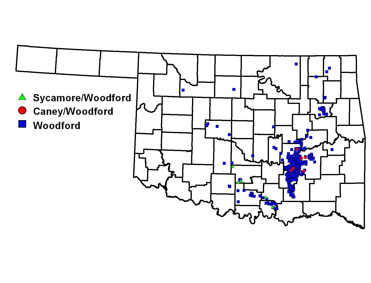
The Devonian Woodford Shale in Oklahoma is from 50 to 300 feet (15 – 91 m) thick. Although the first gas production was recorded in 1939, by late 2004, there were only 24 Woodford Shale gas wells. By early 2008, there were more than 750 Woodford gas wells.[2][1] Like many shale gas plays, the Woodford started with vertical wells, then became dominantly a play of horizontal wells. The play is mostly in the Arkoma Basin of southeast Oklahoma, but some drilling has extended the play west into the Anadarko Basin and south into the Ardmore Basin.[3] The largest gas producer from the Woodford is Newfield Exploration; other operators include Devon Energy, Chesapeake Energy, Cimarex Energy, Antero Resources, St. Mary Land and Exploration, XTO Energy, Pablo Energy, Petroquest Energy, Continental Resources, and Range Resources. Production from the Woodford Shale has peaked and is now in decline, however.[4]
- Oklahoma Geological Survey: Map of Woodford shale wells, accessed 25 February 2009.
- Brian J. Cardott: Overview of Woodford gas-shale play in Oklahoma, 2008 update, PDF file, retrieved 25 February 2009.
Disposal wells
Click here for an interactive map of disposal wells.
As of 2012, there are an estimated 11,000 private and commercial injection and disposal wells in Oklahoma. Each year those wells are injected with billions of gallons of oil and gas wastewater, according to the Oklahoma Corporation Commission -- 8.8 billion gallons of wastewater in the last two years. The Corporation Commission says they have not tallied the amount of water injected through private wells.[5]
Spills and accidents
Click here for an interactive map of spills, leaks, and other drilling incidents.
A 2009 and 2010 report from the EPA Water Quality Protection Division lists concerns the agency has with the state's injection well program, including inaccurately reported data and operators injecting for years without valid permits. Ultimately the report recommends the Corporation Commission in Oklahoma take immediate actions to fix "critical problems."[5]
Worker deaths and injuries
Between October and June 2012, the U.S. Occupational Safety and Health Administration (OSHA) Oklahoma City reported nine work-related deaths in the oil/gas industries and three people who were injured in a drilling rig fire. In response, OSHA, the state Department of Labor, and the Mid-Continent Exploration & Safety Production Network asked Oklahoma’s oil and gas exploration and production companies to stand down and stop operations for a meeting on safety issues.[6]
Tremors
Oklahoma has seen a sharp rise in the number of earthquakes in the last few years. In August 2011, the Oklahoma Geological Survey examined a cluster of earthquakes in Oklahoma and found "that shortly after hydraulic fracturing began small earthquakes started occurring, and more than 50 were identified, of which 43 were large enough to be located. Most of these earthquakes occurred within a 24 hour period after hydraulic fracturing operations had ceased."[7]
On April 18, 2012, University of Memphis scientist Stephen Horton released his findings that a 5.6 quake in November 2011 that knocked down chimneys and headstones 44 miles east of Oklahoma City was "possibly triggered" by injection wells near the fault that ruptured. He did note that the correlation between the location of the quake centers and the wells was complicated by the fact that some of the nearby injection wells had been in operation for 10 years, and the amount of fluid being injected has reportedly been on the decline for the last five years. However, Horton found that 63 percent of earthquakes have occurred within 10 kilometers (about 6 miles) of a deep injection well, compared to a 31 percent chance of a random, natural earthquake happening within 10 kilometers of a deep injection well.[8]
Legislative issues and regulations
In July 2011 the Oklahoma Corporation Commission was established to regulate hydraulic fracturing of oil and gas wells as a well completion operation. The Commission’s environmental protection rules were set up to address various aspects of well completion, and compliance with the rules is assured through inspection, reporting, investigation, and enforcement mechanisms.[9]
Fracking and earthquakes
A 2011 United States Geological Survey (USGS) report, Examination of Possibly Induced Seismicity from Hydraulic Fracturing in the Eola Field, Garvin County, Oklahoma," links a series of earthquakes in Oklahoma in January 2011 to a fracking operation underway there. The USGS found that, overall, some 50 small earthquakes had been registered in the region, ranging in magnitude from 1.0 to 2.8. The bulk occurred within 2.1 miles of Eola Field, a fracking operation in southern Garvin County. The USGS determined that "the character of the seismic recordings indicate that they are both shallow and unique.”
Oklahoma approves fracking disclosures
It was reported in May 2012 that Oklahoma oil and natural gas producers would to forced to disclose the chemicals used in their hydraulic fracturing operations under new rules set to go into effect July 1, 2012. Oklahoma Governor Mary Fallin signed off on the rules, which were approved by the Oklahoma Corporation Commission. Companies will report directly to the commission or use FracFocus.org.[10]
source: http://www.sourcewatch.orgNatural Gas Explosions and Contaminated Water From Fracking Accidents
Not sure what fracking is?
If your family gets its drinking water from a rural water well, you must be aware of the potential for explosions and contaminated water.
Fracking is not a new method of drilling for natural gas, but its dangers to citizens and our environment are becoming more prevalent. Known by names including hydraulic fracturing and hydrofracking, it is a way to get natural gas out of the earth. An oil well is drilled, and then huge amounts of water plus sand, salt and chemicals are forced in to the well. The tremendous pressure fractures the shale deep underground and opens pathways that enable natural gas to flow out of the well more easily.
There are two types of fracking:
- Vertical fracking extends the life of an existing well after it starts being less productive.
- Horizontal fracking is more extreme because it uses a combination of 596 chemical – hundreds of them know to cause cancer – and millions of gallons of water each time a well is fracked. After fracking, this contaminated water is now unfit for consumption and must be cleaned and disposed of.
Some of the personal injury problems your family might have with fracking are:
- Contaminated drinking water from rural wells – After the drilling company pours thousands of gallons of chemical-filled water into a hole, it’s got to go somewhere. And that is likely the water table where rural homes receive their daily drinking and bathing water. It can be dangerous to drink and harmful to bathe in.
- Long-term injury — cancer-causing chemicals